Home
Browse
Ask Us
Chat
Harmful Language Statement
Log in
Photo Archives
Advanced Search
About
Over 90,000 photos covering a variety of topics from Marriott Library Special Collections.
Year
1900
1901
1902
1903
1904
1905
1906
1907
1908
1909
1910
1911
1912
1913
1914
1915
1916
1917
1918
1919
1920
1921
1922
1923
1924
1925
1926
1927
1928
1929
1930
1931
1932
1933
1934
1935
1936
1937
1938
1939
1940
TO
1900
1901
1902
1903
1904
1905
1906
1907
1908
1909
1910
1911
1912
1913
1914
1915
1916
1917
1918
1919
1920
1921
1922
1923
1924
1925
1926
1927
1928
1929
1930
1931
1932
1933
1934
1935
1936
1937
1938
1939
1940
Type
Image
76
Format
image/jpeg
70
application/pdf
6
Collection
Photo Archives
76
Filters:
Date:
"1910"
Spatial Coverage:
"Arizona"
Type:
"Image"
1
-
25
of
76
<
1
2
3
4
>
Gallery view
Number of results to display per page
10
25
50
100
200
Sort by Relevance
Sort by Title A-Z
Sort by Title Z-A
Sort by Date Ascending
Sort by Date Descending
Sort by Last Modified Ascending
Sort by Last Modified Descending
Title
Date
Type
1
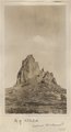
Agathla (John Wetherill photo)
1910
Image
2
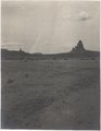
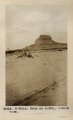
Agathla and Slim (Queen) Rock, Ariz., from S.E. (Photo G144)
1910
Image
3
Agathla and Slim (Queen) Rock, Ariz., from S.E. (Photo G144)
1910
Image
4
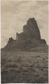
Agathla and Slim (Queen) Rock, Ariz., from S.E. (Photo N-M86)
1910
Image
5
Agathla, volcanic neck, between Chinlee, Ariz. and Oljato, Utah, 1910 (Photo G145)
1910
Image
6
Agathla, volcanic neck, between Chinlee, Ariz. and Oljato, Utah, 1910 (Photo G145)
1910
Image
7
Agathla, volcanic neck, between Chinlee, Ariz. and Oljato, Utah, 1910 (Photo G146)
1910
Image
8
Agathla, volcanic neck, between Chinlee, Ariz. and Oljato, Utah, 1910 (Photo G146)
1910
Image
9
Agathla, volcanic neck, between Chinlee, Ariz. and Oljato, Utah, 1910 (same as G145, Townsend photo)
1910
Image
10
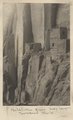
Betatakin Ruin, Sagy Canyon (Townsend photo)
1910
Image
11
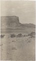
Branch of Navajo Canyon, Ariz., 1910 (Photo G184)
1910
Image
12
Branch of Navajo Canyon, Ariz., 1910 (Photo G184)
1910
Image
13
Brewery Gulch, early Bisbee, Arizona
1900; 1901; 1902; 1903; 1904; 1905; 1906; 1907; 1908; 1909; 1910; 1911; 1912; 1913; 1914; 1915; 1916; 1917; 1918; 1919; 1920; 1921; 1922; 1923; 1924; 1925; 1926; 1927; 1928; 1929; 1930; 1931; 1932; 1933; 1934; 1935; 1936; 1937; 1938; 1939; 1940
Image
14
Butte, junction Sagy canyon with middle of East Branch, Ariz., 1910 (Photo G162)
1910
Image
15
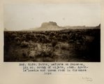
Butte, LaPlata on Dolores, 12+ mi. south of Oljato, Utah. Agathla Needle and QueenRock in distance, 1910 (Photo G159)
1910
Image
16
Butte, LaPlata on Dolores, 12+ mi. south of Oljato, Utah. Agathla Needle in distance, 1910 (Photo N-M91A)
1910
Image
17
Butte, LaPlata on Dolores, 12± mi. south of Oljato, Utah. Agathla Needle in distance, 1910
1910
Image
18
Camp in cave by spring, 8+ mi. southeast of Agathla Needle, 1910 (Photo N-M104)
1910
Image
19
Canyon de Chelly near junction with Canyon del Muerto, 1910 (Edna H. Gregory photo, N-M101)
1910
Image
20
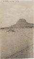
Cha-ez Kla. (No. 4). Volcanic neck or dike, 2+ mi, south of Agathla Needle, Ariz., 1910 (Photo G147)
1910
Image
21
Cliff dwelling in Canyon de Chelly (or near mouth of del Muerto), 1910 (photo by Edna H. Gregory)
1910
Image
22
Cliff, LaPlata on Dolores at mouth of Sagy at Sosi canyon, Ariz., 1910 (Photo G166)
1910
Image
23
Cliff, LaPlata on Dolores at mouth of Sagy at Sosi canyon, AZ. 1910 (Photo G166)
1910
Image
24
Cliff-vein in Canyon de Chelly, 1910.
1910
Image
25
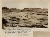
Cross-bedding, Moencopie (?) strata, 6+ mi. northeast of Agathla Needle, Ariz., 1910 (Photo G157)
1910
Image
1
-
25
of
76
<
1
2
3
4
>