| | Title | Date | Type | Setname |
|---|
| 1 | 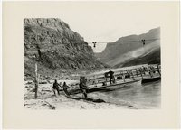 | "Lee's Ferry", across the Colorado river | 1910; 1911; 1912; 1913; 1914; 1915; 1916; 1917; 1918; 1919; 1920; 1921; 1922; 1923; 1924; 1925; 1926; 1927; 1928; 1929; 1930 | Image/StillImage | uum_map |
| 2 | 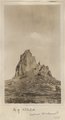 | Agathla (John Wetherill photo) | 1910 | Image | uum_map |
| 3 | 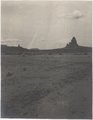 | Agathla and Slim (Queen) Rock, Ariz., from S.E. (Photo G144) | 1910 | Image | uum_map |
| 4 |  | Agathla and Slim (Queen) Rock, Ariz., from S.E. (Photo G144) | 1910 | Image | uum_map |
| 5 |  | Agathla and Slim (Queen) Rock, Ariz., from S.E. (Photo N-M86) | 1910 | Image | uum_map |
| 6 |  | Agathla, volcanic neck, between Chinlee, Ariz. and Oljato, Utah, 1910 (Photo G145) | 1910 | Image | uum_map |
| 7 |  | Agathla, volcanic neck, between Chinlee, Ariz. and Oljato, Utah, 1910 (Photo G145) | 1910 | Image | uum_map |
| 8 | 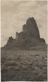 | Agathla, volcanic neck, between Chinlee, Ariz. and Oljato, Utah, 1910 (Photo G146) | 1910 | Image | uum_map |
| 9 |  | Agathla, volcanic neck, between Chinlee, Ariz. and Oljato, Utah, 1910 (Photo G146) | 1910 | Image | uum_map |
| 10 |  | Agathla, volcanic neck, between Chinlee, Ariz. and Oljato, Utah, 1910 (same as G145, Townsend photo) | 1910 | Image | uum_map |
| 11 |  | Andrew Locy Rogers 1910 journal (copy of original) | 1910 | Text | uum_msa |
| 12 |  | Andrew Locy Rogers, Jr., and Rebecca Smith Rogers | 1900; 1901; 1902; 1903; 1904; 1905; 1906; 1907; 1908; 1909; 1910; 1911; 1912; 1913; 1914; 1915; 1916; 1917; 1918; 1919; 1920; 1921; 1922; 1923; 1924; 1925; 1926; 1927; 1928; 1929 | Text | uum_msa |
| 13 |  | Arizona Co-op Mercantile Inst. Holbrook Az. P.1 | 1888; 1889; 1890; 1891; 1892; 1893; 1894; 1895; 1896; 1897; 1898; 1899; 1900; 1901; 1902; 1903; 1904; 1905; 1906; 1907; 1908; 1909; 1910 | Image/StillImage | dha_cp |
| 14 |  | At breakfast typical desert home of Navajo Indians (S. W.) Arizona | 1900; 1901; 1902; 1903; 1904; 1905; 1906; 1907; 1908; 1909; 1910 | Image/StillImage | uaida_main |
| 15 | 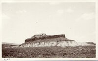 | Battleship Rock - W of Fredonia Arizona | 1907; 1908; 1909; 1910; 1911; 1912; 1913; 1914; 1915; 1916; 1917; 1918; 1919; 1920; 1921; 1922; 1923; 1924; 1925; 1926; 1927; 1928; 1929; 1930; 1931; 1932; 1933; 1934; 1935 | Image/StillImage | uum_map |
| 16 | 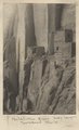 | Betatakin Ruin, Sagy Canyon (Townsend photo) | 1910 | Image | uum_map |
| 17 |  | Branch of Navajo Canyon, Ariz., 1910 (Photo G184) | 1910 | Image | uum_map |
| 18 |  | Branch of Navajo Canyon, Ariz., 1910 (Photo G184) | 1910 | Image | uum_map |
| 19 |  | Brewery Gulch, early Bisbee, Arizona | 1900; 1901; 1902; 1903; 1904; 1905; 1906; 1907; 1908; 1909; 1910; 1911; 1912; 1913; 1914; 1915; 1916; 1917; 1918; 1919; 1920; 1921; 1922; 1923; 1924; 1925; 1926; 1927; 1928; 1929; 1930; 1931; 1932; 1933; 1934; 1935; 1936; 1937; 1938; 1939; 1940 | Image | uum_map |
| 20 |  | Butte, junction Sagy canyon with middle of East Branch, Ariz., 1910 (Photo G162) | 1910 | Image | uum_map |
| 21 | 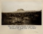 | Butte, LaPlata on Dolores, 12+ mi. south of Oljato, Utah. Agathla Needle and QueenRock in distance, 1910 (Photo G159) | 1910 | Image | uum_map |
| 22 | 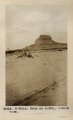 | Butte, LaPlata on Dolores, 12+ mi. south of Oljato, Utah. Agathla Needle in distance, 1910 (Photo N-M91A) | 1910 | Image | uum_map |
| 23 | 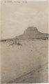 | Butte, LaPlata on Dolores, 12± mi. south of Oljato, Utah. Agathla Needle in distance, 1910 | 1910 | Image | uum_map |
| 24 |  | Cabin in the desert of Arizona [Z-7452] | 1910; 1911; 1912; 1913; 1914; 1915; 1916; 1917 | Image/StillImage | uaida_main |
| 25 |  | Cambridge Ditch men | 1880; 1881; 1882; 1883; 1884; 1885; 1886; 1887; 1888; 1889; 1890; 1891; 1892; 1893; 1894; 1895; 1896; 1897; 1899; 1900; 1901; 1902; 1903; 1904; 1905; 1906; 1907; 1908; 1909; 1910 | Image/StillImage | uaida_main |