Home
Browse
Ask Us
Chat
Harmful Language Statement
Log in
Advanced Search
Year
1880
1881
1882
1883
1884
1885
1886
1887
1888
1889
1890
1891
1892
1893
1894
1895
1896
1897
1898
1899
1900
1901
1902
1903
1904
1905
1906
1907
1908
1909
1910
1911
1912
1913
1914
1915
1916
1917
1918
1919
1920
1921
1922
1923
1924
1925
1926
1927
1928
1929
1930
1931
1932
1933
1934
1935
1936
1937
1938
1939
1940
1941
1942
1943
1944
TO
1880
1881
1882
1883
1884
1885
1886
1887
1888
1889
1890
1891
1892
1893
1894
1895
1896
1897
1898
1899
1900
1901
1902
1903
1904
1905
1906
1907
1908
1909
1910
1911
1912
1913
1914
1915
1916
1917
1918
1919
1920
1921
1922
1923
1924
1925
1926
1927
1928
1929
1930
1931
1932
1933
1934
1935
1936
1937
1938
1939
1940
1941
1942
1943
1944
Type
Image
403
Image/StillImage
34
Text
5
Format
image/jpeg
409
application/pdf
18
Collection
Classified Photographs
4
Mormon Settlement in Arizona
5
Photo Archives
417
UAIDA Main Collection
16
Filters:
Date:
"1909"
Spatial Coverage:
"Arizona"
201
-
225
of
442
<
4
5
6
7
8
9
10
11
12
13
>
Gallery view
Number of results to display per page
10
25
50
100
200
Sort by Relevance
Sort by Title A-Z
Sort by Title Z-A
Sort by Date Ascending
Sort by Date Descending
Sort by Last Modified Ascending
Sort by Last Modified Descending
Title
Date
Type
Setname
201
Lower Oraibi Wash looking west from Little Burro Springs, Ariz., 1909 (photo G-76)
1909
Image
uum_map
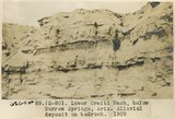
202
Lower Oraibi Wash, 4± miles below Burro Spgs., Ariz., water channel in alluvium, 1909 (photo G-83)
1909
Image
uum_map
203
Lower Oraibi Wash, 8± mi. south of Burro Spgs. Mud balls, 3 to 5 feet in diameter, washed from alluvial canyon during a single shower, 1909 (photo G-84)
1909
Image
uum_map
204
Lower Oraibi Wash, Ariz. (negative of G-83)
1909
Image
uum_map
205
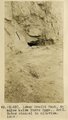
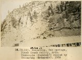
Lower Oraibi Wash, below Burro Springs, Ariz., alluvial deposit on bedrock, 1909 (photo G-80)
1909
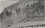
Image
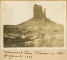
uum_map
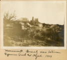
206
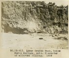
Lower Oraibi Wash, below Burro Springs, Ariz., character of alluvial filling, 1909 (photo G-81)
1909
Image
uum_map
207
Lucasaca Spring, Ariz. Water issues from contact of tuff with underlying sandstone, 1909 (photo G-57)
1909
Image
uum_map
208
Lucasaca Spring, Ariz., general view, 1909 (photo G-58)
1909
Image
uum_map
209
Lucasca Spgs, Ariz. (Negative for photo G-54)
1909
Image
uum_map
210
Lucasca Spgs, Ariz. (Negative for photo G-55)
1909
Image
uum_map
211
Lucasca Spgs, Ariz. (Negative for photo G-56)
1909
Image
uum_map
212
Lucasca Spgs, Ariz. (Negative for photo G-57)
1909
Image
uum_map
213
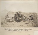
Lunch Camp, Coyote Wash, Ariz. Ham & E.H.G. 1909
1909
Image
uum_map
214
Many Waters Lakes, 16± miles northeast of Leupp, Ariz., view looking west, Monument Point in distance, 1909 (photo G-85)
1909
Image
uum_map
215
Many Waters, Lake and Logan, 1909
1909
Image
uum_map
216
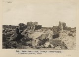
Mesa dwellings, Navojo Reservation (Townsend photo, 1909)
1909
Image
uum_map
217
The Mitten Buttes, Monument Pass, Utah (Townsend photo, 1909)
1909
Image
uum_map
218
The Mitten Buttes, Monument Valley, Utah (Hopkins, Salt Lake City, photo)
1909
Image
uum_map
219
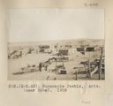
Moencopie Pueblo, Ariz. (near Tuba). 1909
1909
Image
uum_map
220
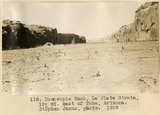
Moencopie Wash, La Plata strata, 12± mi. east of Tuba, Arizona (Stephen Janus photo, 1909)
1909
Image
uum_map
221
Monocline, Oak Springs, Black Creek Valley, Ariz., Moencopie (Permian?) capped by Shinarump (Triassic), 1909 (Photo G-19)
1909
Image
uum_map
222
Monocline, Oak Springs, Black Creek Valley, Ariz., Moencopie (Permian?) capped by Shinarump (Triassic), 1909 (Photo G-19)
1909
Image
uum_map
223
Montezuma's Chair, a volcanic neck, northwest of Chandler's, 30± mi. north-northwest of Winslow, Ariz., 1909 (photo G-72)
1909
Image
uum_map
224
Monument Pass, T. Leader in the foreground, 1909
1909
Image
uum_map
225
Monuments, general view between Gypsum Creek and Abjato [Oljato?], 1909
1909
Image
uum_map
201
-
225
of
442
<
4
5
6
7
8
9
10
11
12
13
>