| Title | Date | Type | Setname | ||
|---|---|---|---|---|---|
| 176 | 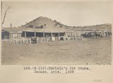 | Hubbell's old store, Ganado, Ariz. 1909 | 1909 | Image | uum_map |
| 177 | 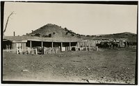 | Hubbell's old store, Ganado, Ariz., 1909. | 1909 | Image/StillImage | uum_map |
| 178 | 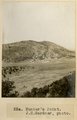 | Hunter's Point (J.H. Gardner, photo) | 1909 | Image | uum_map |
| 179 | 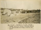 | Hunter's Point, Black Creek Valley, Ariz. Eroded edges of sandstone forming monocline, 1909 (photo G-18) | 1909 | Image | uum_map |
| 180 | 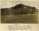 | Hunter's Point, Black Creek Valley, Ariz. Monocline in Moencopie (Permian?) and Shinarump (Triassic?) beds, 1909 (G-17) | 1909 | Image | uum_map |
| 181 | 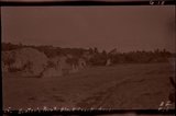 | Hunter's Point, Black Creek Valley, Ariz. (negative for photo G-18) | 1909 | Image | uum_map |
| 182 | 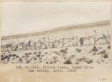 | Indian fence, upper Chinle Valley, Ariz. 1909 | 1909 | Image | uum_map |
| 183 | 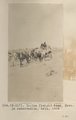 | Indian freight team, Navajo reservation, Ariz., 1909 | 1909 | Image | uum_map |
| 184 | 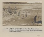 | Indian monuments on the San Juan river. Paiute Indian Reservation. Meaning unknown. Douglass, photo. | 1909 | Image | uum_map |
| 185 | 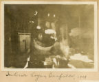 | Interior hogan, Cornfields, 1909 | 1909 | Image | uum_map |
| 186 |  | John Bushman, account book 1882-1931 | 1882; 1883; 1884; 1885; 1886; 1887; 1888; 1889; 1890; 1891; 1892; 1893; 1894; 1895; 1896; 1897; 1898; 1899; 1900; 1901; 1902; 1903; 1904; 1905; 1906; 1907; 1908; 1909; 1910; 1911; 1912; 1913; 1914; 1915; 1916; 1917; 1918; 1919; 1920; 1921; 1922; 1923; 1924; 1925; 1926; 1927; 1928; 1929; 1930; 1931 | Text | uum_msa |
| 187 | 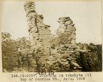 | Jointing in trachyte (?), top of Carriso Mt., Ariz., 1909 (photo G-109) | 1909 | Image | uum_map |
| 188 |  | Journals and sketches of the McLaws, Bradshaw, and Owens families | 1894; 1895; 1896; 1897; 1898; 1899; 1900; 1901; 1902; 1903; 1904; 1905; 1906; 1907; 1908; 1909; 1910; 1911; 1912; 1913; 1914; 1915; 1916; 1917; 1918; 1919; 1920; 1921; 1922; 1923; 1924; 1925; 1926; 1927; 1928; 1929; 1930; 1931; 1932; 1933; 1934; 1935; 1936; 1937; 1938; 1939; 1940; 1941; 1942; 1943; ... | Text | uum_msa |
| 189 | 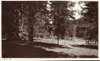 | Kaibab Plateau | 1907; 1908; 1909; 1910; 1911; 1912; 1913; 1914; 1915; 1916; 1917; 1918; 1919; 1920; 1921; 1922; 1923; 1924; 1925; 1926; 1927; 1928; 1929; 1930; 1931; 1932; 1933; 1934; 1935 | Image/StillImage | uum_map |
| 190 | 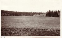 | Kaibab Plateau | 1907; 1908; 1909; 1910; 1911; 1912; 1913; 1914; 1915; 1916; 1917; 1918; 1919; 1920; 1921; 1922; 1923; 1924; 1925; 1926; 1927; 1928; 1929; 1930; 1931; 1932; 1933; 1934; 1935 | Image/StillImage | uum_map |
| 191 | 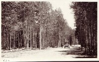 | Kaibab Plateau | 1907; 1908; 1909; 1910; 1911; 1912; 1913; 1914; 1915; 1916; 1917; 1918; 1919; 1920; 1921; 1922; 1923; 1924; 1925; 1926; 1927; 1928; 1929; 1930; 1931; 1932; 1933; 1934; 1935 | Image/StillImage | uum_map |
| 192 | 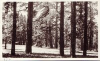 | Kaibab Plateau | 1907; 1908; 1909; 1910; 1911; 1912; 1913; 1914; 1915; 1916; 1917; 1918; 1919; 1920; 1921; 1922; 1923; 1924; 1925; 1926; 1927; 1928; 1929; 1930; 1931; 1932; 1933; 1934; 1935 | Image/StillImage | uum_map |
| 193 | 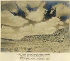 | Keams Canyon (Mesa Verde strata) looking west from Hubbell's store (A. C. Vroman photo, Pasadena, Cal.) | 1909 | Image | uum_map |
| 194 | 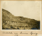 | Landslide near Sunrise Springs, 1909 | 1909 | Image | uum_map |
| 195 | 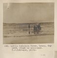 | Little Colorado River, Leupp, May 1909. Stuck in quicksand. H. F. Robinson, photo. | 1909 | Image | uum_map |
| 196 | 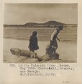 | Little Colorado River, Luepp, May 1909. Mendenhall, Gregory, and Navajo. H. F. Robinson, photo. | 1909 | Image | uum_map |
| 197 | 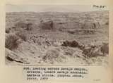 | Looking across Navajo Canyon, Arizona, toward Navajo Mountain. La Plata strata (Stephen Janus photo, 1909) | 1909 | Image | uum_map |
| 198 | 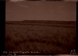 | Lower Coyote Wash (negative for photo G-75) | 1909 | Image | uum_map |
| 199 | 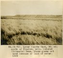 | Lower Coyote Wash, 35± mi. north of Winslow, Ariz. Dolores (Triassic) Mesa. Shows grass not used because of lack of water, 1909 (photo G-75) | 1909 | Image | uum_map |
| 200 |  | Lower Oraibi Wash (negative of G-81) | 1909 | Image | uum_map |