Home
Browse
Ask Us
Chat
Harmful Language Statement
Log in
Advanced Search
Year
1880
1881
1882
1883
1884
1885
1886
1887
1888
1889
1890
1891
1892
1893
1894
1895
1896
1897
1898
1899
1900
1901
1902
1903
1904
1905
1906
1907
1908
1909
1910
1911
1912
1913
1914
1915
1916
1917
1918
1919
1920
1921
1922
1923
1924
1925
1926
1927
1928
1929
1930
1931
1932
1933
1934
1935
1936
1937
1938
1939
1940
1941
1942
1943
1944
TO
1880
1881
1882
1883
1884
1885
1886
1887
1888
1889
1890
1891
1892
1893
1894
1895
1896
1897
1898
1899
1900
1901
1902
1903
1904
1905
1906
1907
1908
1909
1910
1911
1912
1913
1914
1915
1916
1917
1918
1919
1920
1921
1922
1923
1924
1925
1926
1927
1928
1929
1930
1931
1932
1933
1934
1935
1936
1937
1938
1939
1940
1941
1942
1943
1944
Type
Image
403
Image/StillImage
34
Text
5
Format
image/jpeg
409
application/pdf
18
Collection
Classified Photographs
4
Mormon Settlement in Arizona
5
Photo Archives
417
UAIDA Main Collection
16
Filters:
Date:
"1909"
Spatial Coverage:
"Arizona"
76
-
100
of
442
<
1
2
3
4
5
6
7
8
9
10
>
Gallery view
Number of results to display per page
10
25
50
100
200
Sort by Relevance
Sort by Title A-Z
Sort by Title Z-A
Sort by Date Ascending
Sort by Date Descending
Sort by Last Modified Ascending
Sort by Last Modified Descending
Title
Date
Type
Setname
76
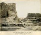
Canyon de Chelly, 1± above White House (Moencopie strata), 1909 (W. C. Mendenhall, photo, U.S.G.S.)
1909
Image
uum_map
77
Canyon de Chelly, 3± mi. below Monument Canyon (Moencopie strata), 1909 (W. C. Mendenhall, photo, U.S.G.S.)
1909
Image
uum_map
78
Canyon de Chelly, 4± mi. below Monument Canyon (Moencopie strata), 1909 (W. C. Mendenhall, photo, U.S.G.S.)
1909
Image
uum_map
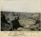
79
Canyon de Chelly, near "Peach Orchard" (Moencopie shale), 1909 (M. R. Campbell, photo, U.S.G.S.)
1909
Image
uum_map
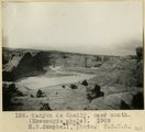
80
Canyon de Chelly, near mouth (Moencopie shale), 1909 (M. R. Campbell, photo, U.S.G.S.)
1909
Image
uum_map
81
Canyon de Chelly, north wall midway between Canyon del Muerto and Monument Canyon. Moencopie strata, 1909 (W. C. Mendenhall, photo, U.S.G.S.)
1909
Image
uum_map
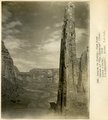
82
Canyon de Chelly, view down stream at "The Captains" (Moencopie strata), 1909 (W. C. Mendenhall, photo, U.S.G.S.)
1909
Image
uum_map
83
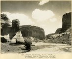
Canyon de Chelly, view from rim near mouth, 1909 (M. R. Campbell, photo, U.S.G.S.)
1909
Image
uum_map
84
Canyon del Muerto, 2± mi. above mouth (Moencopie strata), 1909 (W. C. Mendenhall, photo, U.S.G.S.)
1909
Image
uum_map
85
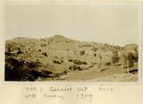
Carriso Mt., Ariz., W. B. Emory photo, 1909
1909
Image
uum_map
86
Cliffs (Dolores strata) east of Little Colorado at Tolchaco, Arizona, 1909 (photo G-88)
1909
Image
uum_map
87
Cliffs at Lyon's Ranch, near Tuba, Ariz. Lower La Plata or upper Dolores strata, M. R. Campbell photo, 1909
1909
Image
uum_map
88
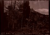
Columns, Zilh-Tusayan, igneous mass, 20± mil. northwest of Fort Defiance, Ariz., 1909 (photo G-21)
1909
Image
uum_map
89
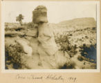
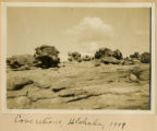
Concretions (Dakota?), Hlohala, Ariz., 1909 (photo G-106)
1909
Image
uum_map
90
Concretions (Dakota?), Hlohala, Ariz., 1909 (photo G-106)
1909
Image
uum_map
91
Concretions, Hlohala, 1909
1909
Image
uum_map
92
Concretions, Hlohala, 1909
1909
Image
uum_map
93
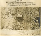
Conglomerate forming part of Black Rock; igneous mass, Ft. Defiance, Ariz., 1909 (photo G-15)
1909
Image
uum_map
94
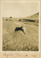
Coyote, Ganado 1909
1909
Image
uum_map
95
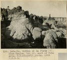
Details, McElmo or La Plata (?), Blue Canyon, 18± mi. east of Tuba, Ariz. (M. R. Campbell photo, 1909, U.S.G.S.)
1909
Image
uum_map
96
Diaries of John Bushman, 1871-1923, part 2: 1890-1923
1890; 1891; 1892; 1893; 1894; 1895; 1896; 1897; 1898; 1899; 1900; 1901; 1902; 1903; 1904; 1905; 1906; 1907; 1908; 1909; 1910; 1911; 1912; 1913; 1914; 1915; 1916; 1917; 1918; 1919; 1920; 1921; 1922; 1923
Text
uum_msa
97
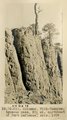
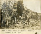
Dike of diabase, Whiskey Creek, Ariz. (negative for photo G-102)
1909
Image
uum_map
98
Dike of diabase, Whiskey Creek, Ariz., 1909 (photo G-102)
1909
Image
uum_map
99
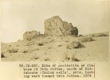
Dike of peridotite or diabase at Twin Buttes, south of Beddehoche (Indian Wells), Ariz. Looking west twoard Twin Buttes, 1909 (photo G-63)
1909
Image
uum_map
100
Dike of peridotite, Twin Buttes (Negative for photo G63)
1909
Image
uum_map
76
-
100
of
442
<
1
2
3
4
5
6
7
8
9
10
>