Home
Browse
Ask Us
Chat
Harmful Language Statement
Log in
Advanced Search
Year
1880
1881
1882
1883
1884
1885
1886
1887
1888
1889
1890
1891
1892
1893
1894
1895
1896
1897
1898
1899
1900
1901
1902
1903
1904
1905
1906
1907
1908
1909
1910
1911
1912
1913
1914
1915
1916
1917
1918
1919
1920
1921
1922
1923
1924
1925
1926
1927
1928
1929
1930
1931
1932
1933
1934
1935
1936
1937
1938
1939
1940
1941
1942
1943
1944
TO
1880
1881
1882
1883
1884
1885
1886
1887
1888
1889
1890
1891
1892
1893
1894
1895
1896
1897
1898
1899
1900
1901
1902
1903
1904
1905
1906
1907
1908
1909
1910
1911
1912
1913
1914
1915
1916
1917
1918
1919
1920
1921
1922
1923
1924
1925
1926
1927
1928
1929
1930
1931
1932
1933
1934
1935
1936
1937
1938
1939
1940
1941
1942
1943
1944
Type
Image
403
Image/StillImage
34
Text
5
Format
image/jpeg
409
application/pdf
18
Collection
Classified Photographs
4
Mormon Settlement in Arizona
5
Photo Archives
417
UAIDA Main Collection
16
Filters:
Date:
"1909"
Spatial Coverage:
"Arizona"
26
-
50
of
442
<
1
2
3
4
5
6
7
8
9
10
>
Gallery view
Number of results to display per page
10
25
50
100
200
Sort by Relevance
Sort by Title A-Z
Sort by Title Z-A
Sort by Date Ascending
Sort by Date Descending
Sort by Last Modified Ascending
Sort by Last Modified Descending
Title
Date
Type
Setname
26
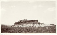
Basalt-capped mesa with dike on Dolores (Triassic), 8± miles south-southwest of Beddehoche (Indian Wells), Ariz., 1909 (photo G-66)
1909
Image
uum_map
27
Basalt-capped mesa, Biddehoche, Ariz. (negative for photo G-68)
1909
Image
uum_map
28
Battleship Rock - W of Fredonia Arizona
1907; 1908; 1909; 1910; 1911; 1912; 1913; 1914; 1915; 1916; 1917; 1918; 1919; 1920; 1921; 1922; 1923; 1924; 1925; 1926; 1927; 1928; 1929; 1930; 1931; 1932; 1933; 1934; 1935
Image/StillImage
uum_map
29
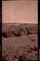
Beautiful Valley, Arizona (Negative for photo G-30)
1909
Image
uum_map
30
Beautiful Valley, fossil forest (Negative for photo G-29)
1909
Image
uum_map
31
Beautiful Valley, fossil forest (Negative for photo G-31)
1909
Image
uum_map
32
Beautiful Valley." Fossil forest (Dolores strata), 12± mi. north of Ganado, Ariz. Pebbles in foreground are chips of petrified wood, 1909 (photo G-32)
1909
Image
uum_map
33
Beautiful Valley." Fossil forest (Dolores strata), 12± mi. north of Ganado, Ariz. All pebbles in foreground are petrified wood, 1909 (photo G-28)
1909
Image
uum_map
34
Beautiful Valley." Fossil forest, Dolores strata, petrified log, 1909 (photo G-29)
1909
Image
uum_map
35
Beautiful Valley." Fossil forest, Dolores strata, petrified log, 1909 (photo G-30)
1909
Image
uum_map
36
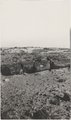
Bed of Little Colorado, Black Falls (negative for photo G-92)
1909
Image
uum_map
37
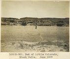
Bed of Little Colorado, Black Falls, June 1909 (photo G-92)
1909
Image
uum_map
38
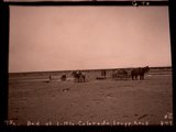
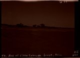
Bed of Little Colorado, Leupp, Ariz. (negative for photo G-90)
1909
Image
uum_map
39
Bed of Little Colorado, Leupp, Arizona (negative for photo G-89)
1909
Image
uum_map
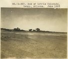
40
Bed of Little Colorado, Leupp, Arizona, June 1909 (photo G-89)
1909
Image
uum_map
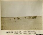
41
Bed of Little Colorado, Leupp, Arizona, May 1909 (photo G-90)
1909
Image
uum_map
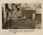
42
Betatakin cliff ruins, west branch of Sagy canon, Ariz., (Townsend photo, 1909)
1909
Image
uum_map
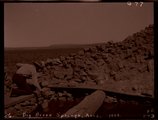
43
Big Burro Springs, Arizona, 1909 (negative for photo G-77)
1909
Image
uum_map
44
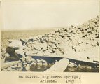
Big Burro Springs, Arizona, 1909 (photo G-77)
1909
Image
uum_map
45
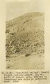
Black Creek Valley, Arizona (negative for photo G-11)
1909
Image
uum_map
46
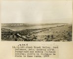
Black Creek Valley, Fort Defiance, Ariz. Looking north. Foreground and middle distance Dolores; cliffs in distance La Plata to Mesa Verde, 1909 (photo G-13)
1909
Image
uum_map
47
Black Creek Valley, Fort Defiance, Ariz. Looking north. Foreground and middle distance Dolores; cliffs in distance La Plata to Mesa Verde, 1909 (photo G-13)
1909
Image
uum_map
48
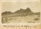
Black Rock near Ft. Defiance, 1909
1909
Image
uum_map
49
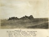
Black Rock, Ft. Defiance, Ariz. Dike of diabase. Looking east. La Plata sandstone in distance. Detailed structure, 1909 (photo G-14)
1909
Image
uum_map
50
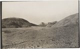
Blue Canyon, Ariz. (negative for G-5)
1909
Image
uum_map
26
-
50
of
442
<
1
2
3
4
5
6
7
8
9
10
>