Home
Browse
Ask Us
Chat
Harmful Language Statement
Log in
Advanced Search
Year
1880
1881
1882
1883
1884
1885
1886
1887
1888
1889
1890
1891
1892
1893
1894
1895
1896
1897
1898
1899
1900
1901
1902
1903
1904
1905
1906
1907
1908
1909
1910
1911
1912
1913
1914
1915
1916
1917
1918
1919
1920
1921
1922
1923
1924
1925
1926
1927
1928
1929
1930
1931
1932
1933
1934
1935
1936
1937
1938
1939
1940
1941
1942
1943
1944
TO
1880
1881
1882
1883
1884
1885
1886
1887
1888
1889
1890
1891
1892
1893
1894
1895
1896
1897
1898
1899
1900
1901
1902
1903
1904
1905
1906
1907
1908
1909
1910
1911
1912
1913
1914
1915
1916
1917
1918
1919
1920
1921
1922
1923
1924
1925
1926
1927
1928
1929
1930
1931
1932
1933
1934
1935
1936
1937
1938
1939
1940
1941
1942
1943
1944
Type
Image
403
Image/StillImage
34
Text
5
Format
image/jpeg
409
application/pdf
18
Collection
Classified Photographs
4
Mormon Settlement in Arizona
5
Photo Archives
417
UAIDA Main Collection
16
Filters:
Date:
"1909"
Spatial Coverage:
"Arizona"
426
-
450
of
442
<
9
10
11
12
13
14
15
16
17
18
>
Gallery view
Number of results to display per page
10
25
50
100
200
Sort by Relevance
Sort by Title A-Z
Sort by Title Z-A
Sort by Date Ascending
Sort by Date Descending
Sort by Last Modified Ascending
Sort by Last Modified Descending
Title
Date
Type
Setname
426
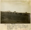
Volcanic necks; view looking southeast from Chandler's Ranch (30± mi. north-northeast of Winslow, Ariz.), toward Chimney Butte, 1909 (photo G-70)
1909
Image
uum_map
427
Volcanic necks; view looking southeast from Chandler's Ranch (30± mi. north-northeast of Winslow, Ariz.), toward Chimney Butte, 1909 (photo G-70)
1909
Image
uum_map
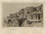
428
Walpi
1909
Image
uum_map
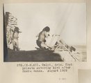
429
Walpi, Ariz. Hopi priests entering kivi after Snake dance. August 1909
1909
Image
uum_map
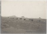
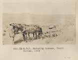
430
Watering horses, Moqui Buttes, 1909
1909
Image
uum_map
431
Webo Spgs., water from Mesa Verde sandstones (negative for photo G-97)
1909
Image
uum_map
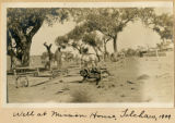
432
Well at mission house, Tolchaco, 1909
1909
Image
uum_map
433
Wepo Spgs., Ariz., water from Mesa Verde sandstones at contact with shale, 1909 (photo G-97)
1909
Image
uum_map
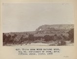
434
White Mesa with natural arch, 40+ mi. north east of Tuba, Ariz. (Stephen Janus photo), 1909
1909
Image
uum_map
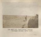
435
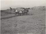
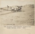
Wild horse, Little Colorado Valley, Ariz. 1909
1909
Image
uum_map
436
Wild horses, Little Colorado Valley, Ariz. 1909
1909
Image
uum_map
437
Wild horses, Little Colorado Valley, Ariz. 1909
1909
Image
uum_map
438
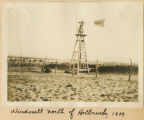
Windmill north of Holbrook, 1909
1909
Image
uum_map
439
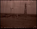
Windmills no. of Holbrook, Ariz., 1909 (negative for photo G-77)
1909
Image
uum_map
440
Windmills with points driven into alluvial sand, 10± miles north of Holbrook, Ariz., 1909 (photo G-79)
1909
Image
uum_map
441
Zilh-Tusayan, igneous mass, 20± mi. northwest of Fort Defiance, Arizona, 1909 (photo G-20)
1909
Image
uum_map
442
Zilh-Tusayan, igneous mass, 20± mi. northwest of Fort Defiance, Arizona, 1909 (photo G-20)
1909
Image
uum_map
426
-
450
of
442
<
9
10
11
12
13
14
15
16
17
18
>