Home
Browse
Ask Us
Chat
Harmful Language Statement
Log in
Advanced Search
Year
1880
1881
1882
1883
1884
1885
1886
1887
1888
1889
1890
1891
1892
1893
1894
1895
1896
1897
1898
1899
1900
1901
1902
1903
1904
1905
1906
1907
1908
1909
1910
1911
1912
1913
1914
1915
1916
1917
1918
1919
1920
1921
1922
1923
1924
1925
1926
1927
1928
1929
1930
1931
1932
1933
1934
1935
1936
1937
1938
1939
1940
1941
1942
1943
1944
TO
1880
1881
1882
1883
1884
1885
1886
1887
1888
1889
1890
1891
1892
1893
1894
1895
1896
1897
1898
1899
1900
1901
1902
1903
1904
1905
1906
1907
1908
1909
1910
1911
1912
1913
1914
1915
1916
1917
1918
1919
1920
1921
1922
1923
1924
1925
1926
1927
1928
1929
1930
1931
1932
1933
1934
1935
1936
1937
1938
1939
1940
1941
1942
1943
1944
Type
Image
403
Image/StillImage
34
Text
5
Format
image/jpeg
409
application/pdf
18
Collection
Classified Photographs
4
Mormon Settlement in Arizona
5
Photo Archives
417
UAIDA Main Collection
16
Filters:
Date:
"1909"
Spatial Coverage:
"Arizona"
326
-
350
of
442
<
9
10
11
12
13
14
15
16
17
18
>
Gallery view
Number of results to display per page
10
25
50
100
200
Sort by Relevance
Sort by Title A-Z
Sort by Title Z-A
Sort by Date Ascending
Sort by Date Descending
Sort by Last Modified Ascending
Sort by Last Modified Descending
Title
Date
Type
Setname
326
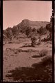
Round Top, Ganado, Ariz. (Negative for photo G-36)
1909
Image
uum_map
327
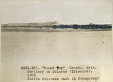
Round Top," Ganado, Ariz. Tertiary on Dolores (Triassic), 1909. Pueblo, Colorado wash in foreground (photo G-35)
1909
Image
uum_map
328
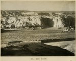
Round Top," Ganado, Ariz. Tertiary on Dolores (Triassic), 1909 (photo G-36)
1909
Image
uum_map
329
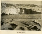
Sagy at Soci canyon, Ariz. Walls of LaPlata sandstone. Skeleton Mesa in distance (S.M. Young photo, 1909)
1909
Image
uum_map
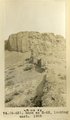
330
Same as 113 (Reservoir canyon, Tuba, Ariz. (La Plata strata), Stephen Janus photo, 1908
1909
Image
uum_map
331
Same as 120 (Blue Canyon east of Tuba, Arizona, by W. C. Mendenhall, U.S.G.S.)
1909
Image
uum_map
332
Same as 120 (Blue Canyon east of Tuba, Arizona, by W. C. Mendenhall, U.S.G.S.)
1909
Image
uum_map
333
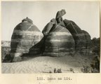
Same as 124 (Rock detail, McElmo or La Plata (?), Blue Canyon, 18± mi. east of Tuba, Ariz. (M. R. Campbell photo, 1909, U.S.G.S.)
1909
Image
uum_map
334
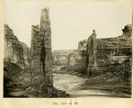
Same as 135 : Canyon de Chelly, view down stream at "The Captains" (Moencopie strata), 1909 (W. C. Mendenhall, photo, U.S.G.S.)
1909
Image
uum_map
335
Same as 135 : Canyon de Chelly, view upstream at "The Captains" (Moencopie strata), 1909 (W. C. Mendenhall, photo, U.S.G.S.)
1909
Image
uum_map
336
The same as G-45: Tertiary clay shales interbedded with tuff. "Black Rock" between Sunrise Springs and Biddehoche (Indian wells), Ariz., 1909 (photo G-46)
1909
Image
uum_map
337
Same as G-52 (Tertiary clay shales interbeddied with tuff south of Biddehoche, Ariz., 1909 (photo G-53)
1909
Image
uum_map
338
Same as G-52 (Tertiary clay shales interbeddied with tuff, 2± mi. south of Biddehoche, Ariz., 1909, negative for photo G-53)
1909
Image
uum_map
339
Same as G-63 (Dike of peridotite or diabase at Twin Buttes, south of Beddehoche), 1909 (photo G-64)
1909
Image
uum_map
340
Same as G-63, looking east (Dike of peridotite or diabase at Twin Buttes, south of Beddehoche), 1909 (photo G-65)
1909
Image
uum_map
341
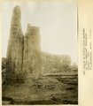
Same as G-72 (Montezuma's Chair, negative for photo G-73)
1909
Image
uum_map
342
Same as G-72, nearer view: a volcanic neck, northwest of Chandler's Ranch (photo G-73)
1909
Image
uum_map
343
Same as G-72, nearer view: a volcanic neck, northwest of Chandler's Ranch (photo G-73)
1909
Image
uum_map
344
Same as G-72, nearer view: Montezuma's Chair, a volcanic neck, northwest of Chandler's Ranch (photo G-74)
1909
Image
uum_map
345
Same as G-81 (alluvial beds at Lower Oraibi Wash below Burro Springs, Arizona, negative for photo G-82)
1909
Image
uum_map
346
Same as G-81 (alluvial beds at Lower Oraibi Wash below Burro Springs, Arizona, photo G-82)
1909
Image
uum_map
347
Same as G-81 (alluvial beds at Lower Oraibi Wash below Burro Springs, Arizona, photo G-82)
1909
Image
uum_map
348
Same as G-85 (Many Waters Lake, Arizona, negative for photo G-86)
1909
Image
uum_map
349
Same as G-85 (Many Waters Lake, Arizona, photo G-86)
1909
Image
uum_map
350
Same as G-85 (Many Waters Lake, Arizona, photo G-86)
1909
Image
uum_map
326
-
350
of
442
<
9
10
11
12
13
14
15
16
17
18
>