|
|
Title | Collection Number And Name | Photo Number |
| 1 |
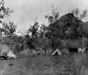 |
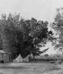
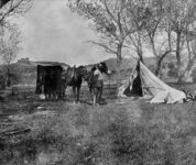
Men cooking breakfast and hanging wash outside of their tents in southern Utah. | P0068 Dick Beck Photograph Collection | P0068 n 01 |
| 2 |
 |
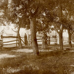
Men standing next to a fenced area containing beehives in Bluff, Utah. One man is wearing a protective head covering used while collecting honey. | P0068 Dick Beck Photograph Collection | P0068 n 012 |
| 3 |
 |
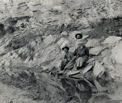
Women sitting on a dry river bank watching a man holding a pan. | P0068 Dick Beck Photograph Collection | P0068 n 013 |
| 4 |
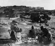 |
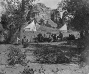
Woman and men eating a picnic lunch in a dry southern Utah landscape. | P0068 Dick Beck Photograph Collection | P0068 n 014 |
| 5 |
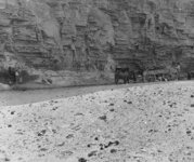 |
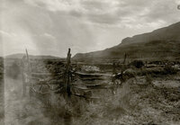
Horses and a wagon parked in a dry river bed. | P0068 Dick Beck Photograph Collection | P0068 n 015 |
| 6 |
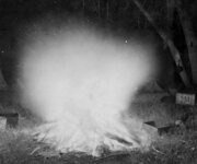 |
Pans surrounding a blazing campfire. | P0068 Dick Beck Photograph Collection | P0068 n 016 |
| 7 |
 |
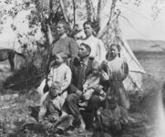
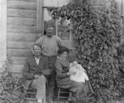
Outdoor family portrait. | P0068 Dick Beck Photograph Collection | P0068 n 017 |
| 8 |
 |
Outdoor family portrait in front of a tent. | P0068 Dick Beck Photograph Collection | P0068 n 018 |
| 9 |
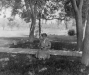 |
Woman sitting on a boardwalk looking at a stick or root. | P0068 Dick Beck Photograph Collection | P0068 n 019 |
| 10 |
 |
Man and woman standing near a cabin with tents pitched in front. | P0068 Dick Beck Photograph Collection | P0068 n 02 |
| 11 |
 |
Woman walking under the trees gathering food in her apron. | P0068 Dick Beck Photograph Collection | P0068 n 020 |
| 12 |
 |
Family gathered in front of a cabin for a portrait. | P0068 Dick Beck Photograph Collection | P0068 n 021 |
| 13 |
 |
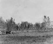
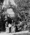
Distant view of women gathered in front of a cabin in southern Utah. | P0068 Dick Beck Photograph Collection | P0068 n 022 |
| 14 |
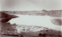 |
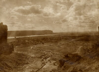
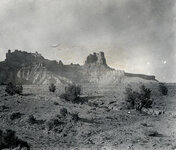
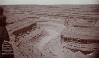
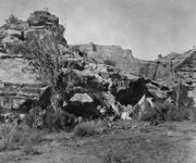
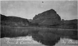
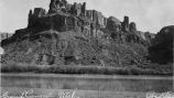
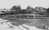
"Hermit Lake in western San Juan Co., Utah. 12 miles east of Colorado River, 1/4 mile wide and 1/2 mile long. The Henry Mountains, faintly seen, 75 miles distant." This lake was on the famous Hole-in-the-Rock trail. The natural dam failed in 1914? The lake no longer exists. | P0068 Dick Beck Photograph Collection | P0068 n 023 |
| 15 |
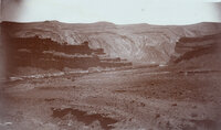 |
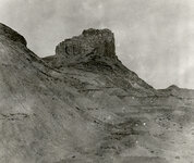
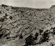
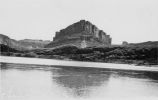
"Some rocks, Bluff, Utah. Blue lime forms the background while deep shaded parts are red lime ot trias rocks. View from San Juan Oil Field." | P0068 Dick Beck Photograph Collection | P0068 n 024 |
| 16 |
 |
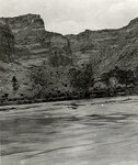
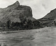
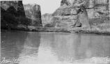
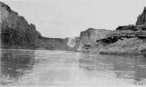
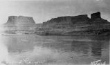
Scenic view of a river in Southern Utah from high on a bluff. | P0068 Dick Beck Photograph Collection | P0068 n 025 |
| 17 |
 |
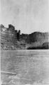
Scenic view of a river in Southern Utah from high on a bluff. | P0068 Dick Beck Photograph Collection | P0068 n 026 |
| 18 |
 |
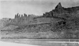
Scenic view of a river in Southern Utah from high on a bluff. | P0068 Dick Beck Photograph Collection | P0068 n 027 |
| 19 |
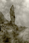
 |
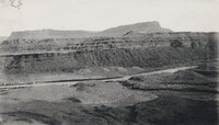
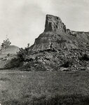
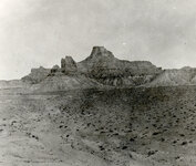
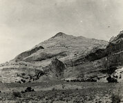
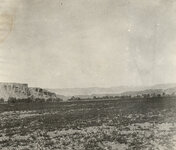
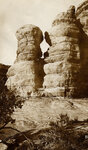
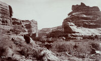
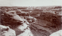
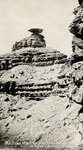
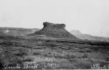
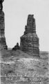
Southern Utah rock formations. | P0068 Dick Beck Photograph Collection | P0068 n 028 |
| 20 |
 |
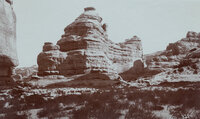
Southern Utah rock formations. | P0068 Dick Beck Photograph Collection | P0068 n 029 |
| 21 |
 |
Man standing in the middle of his camp, holding the reins of a saddle horse. | P0068 Dick Beck Photograph Collection | P0068 n 03 |
| 22 |
 |
Southern Utah rock formations. | P0068 Dick Beck Photograph Collection | P0068 n 030 |
| 23 |
 |
Scenic view of a river in Southern Utah from high on a bluff. | P0068 Dick Beck Photograph Collection | P0068 n 031 |
| 24 |
 |
Two men and a woman sitting on a slope above a stagnant pool of water. | P0068 Dick Beck Photograph Collection | P0068 n 032 |
| 25 |
 |
Southern Utah rock formations. | P0068 Dick Beck Photograph Collection | P0068 n 033 |
| 26 |
 |
Southern Utah rock formations. | P0068 Dick Beck Photograph Collection | P0068 n 034 |
| 27 |
 |
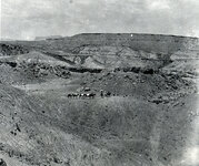
Men herding horses through a desert landscape. | P0068 Dick Beck Photograph Collection | P0068 n 035 |
| 28 |
 |
Southern Utah rock formations. | P0068 Dick Beck Photograph Collection | P0068 n 036 |
| 29 |
 |
Men leading pack horses across a desert landscape. | P0068 Dick Beck Photograph Collection | P0068 n 037 |
| 30 |
 |
Southern Utah rock formations and landscape. | P0068 Dick Beck Photograph Collection | P0068 n 038 |
| 31 |
 |
Unidentified river rushing around a sandstone bluff. | P0068 Dick Beck Photograph Collection | P0068 n 039 |
| 32 |
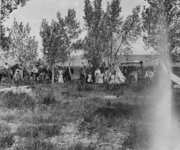 |
Large group of women, men and children standing in camp. | P0068 Dick Beck Photograph Collection | P0068 n 04 |
| 33 |
 |
Southern Utah rock formations and landscape. | P0068 Dick Beck Photograph Collection | P0068 n 040 |
| 34 |
 |
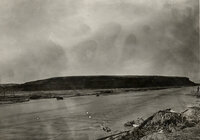
River meandering through a desert landscape. | P0068 Dick Beck Photograph Collection | P0068 n 041 |
| 35 |
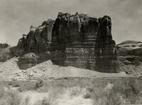 |
Southern Utah rock formations and landscape. | P0068 Dick Beck Photograph Collection | P0068 n 042 |
| 36 |
 |
Southern Utah rock formations and landscape. | P0068 Dick Beck Photograph Collection | P0068 n 043 |
| 37 |
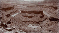 |
"Mound Loop, San Juan River Canyon. Scene in oil field 30 miles west of Bluff, Utah. Two miles around loop and 800 feet deep." | P0068 Dick Beck Photograph Collection | P0068 n 044 |
| 38 |
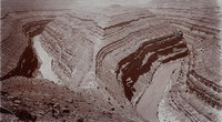 |
"Goose-neck Loop, San Juan River Canyon, 33 miles west of Bluff, Utah. Three miles around Loop and 1000 feet deep." | P0068 Dick Beck Photograph Collection | P0068 n 045 |
| 39 |
 |
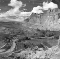
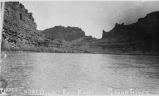
"General view of San Juan River Canyon, Utah at Mendenhall's camp. 1000 feet deep." | P0068 Dick Beck Photograph Collection | P0068 n 046 |
| 40 |
 |
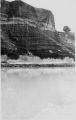
Southern Utah rock formation and landscape. | P0068 Dick Beck Photograph Collection | P0068 n 049 |
| 41 |
 |
Distant view of men working in camp with horses grazing nearby. | P0068 Dick Beck Photograph Collection | P0068 n 05 |
| 42 |
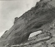 |
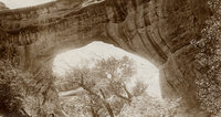
Southern Utah rock arch formation and landscape. | P0068 Dick Beck Photograph Collection | P0068 n 050 |
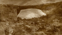
| 43 |
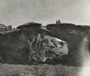 |
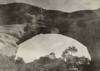
Men sitting on top of an arch, under which a young girl and horse are standing. | P0068 Dick Beck Photograph Collection | P0068 n 051 |
| 44 |
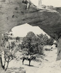 |
Man on horseback under an arch on which two men are standing. | P0068 Dick Beck Photograph Collection | P0068 n 052 |
| 45 |
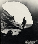 |
Silhouette of an arch framing a man on horseback. | P0068 Dick Beck Photograph Collection | P0068 n 053 |
| 46 |
 |
Owachimo National Bridge, Natural Bridge National Monument. | P0068 Dick Beck Photograph Collection | P0068 n 054 |
| 47 |
 |
Owachimo National Bridge, Natural Bridge National Monument. | P0068 Dick Beck Photograph Collection | P0068 n 055 |
| 48 |
 |
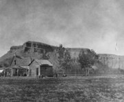
Southern Utah rock formation and landscape. | P0068 Dick Beck Photograph Collection | P0068 n 056 |
| 49 |
 |
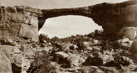
Sipapu Natural Bridge, Natural Bridges National Monument. | P0068 Dick Beck Photograph Collection | P0068 n 057 |
| 50 |
 |
Man climbing the rocks at the Garden of Eden? | P0068 Dick Beck Photograph Collection | P0068 n 058 |
| 51 |
 |
Men standing on top of Sipapu Natural Bridge, Natural Bridges National Monument. | P0068 Dick Beck Photograph Collection | P0068 n 059 |
| 52 |
 |
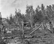
Men and women sitting in the shade drinking water near their tents. | P0068 Dick Beck Photograph Collection | P0068 n 06 |
| 53 |
 |
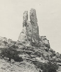
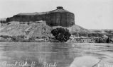
"Victoria Camp, Grand Gulch, San Juan County, Utah. Queen Vic's profiled is seen on top of cliff, right side." | P0068 Dick Beck Photograph Collection | P0068 n 060 |
| 54 |
 |
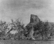
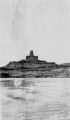
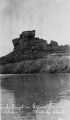
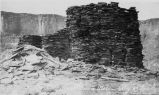
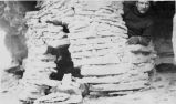
"Mokee Castle, Grand Gulch, San Juan County, Utah. Around its base and under its sheltering cliffs were found many relics of the old cliff-dwellers." | P0068 Dick Beck Photograph Collection | P0068 n 061 |
| 55 |
 |
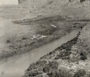
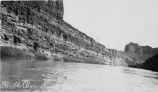
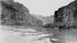
"Grand Gulch near junction with San Juan River. 600 feet deep." | P0068 Dick Beck Photograph Collection | P0068 n 062 |
| 56 |
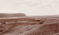 |
"Looking southwest from Bluff, Utah." | P0068 Dick Beck Photograph Collection | P0068 n 063 |
| 57 |
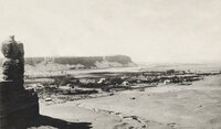 |
"Looking southwest from Bluff, Utah." | P0068 Dick Beck Photograph Collection | P0068 n 064 |
| 58 |
 |
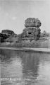
"Mexican Hat on the San Juan River at Wilson's Camp." | P0068 Dick Beck Photograph Collection | P0068 n 065 |
| 59 |
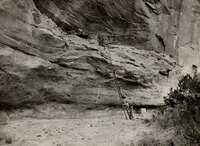 |
Men and women climbing a long ladder up a cliff to examine the ruins of a cliff-dweller settlement. | P0068 Dick Beck Photograph Collection | P0068 n 066 |
| 60 |
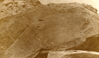 |
Petroglyphs in San Juan County, Utah. | P0068 Dick Beck Photograph Collection | P0068 n 067 |
| 61 |
 |
Men and women standing near their horses outside of camp. | P0068 Dick Beck Photograph Collection | P0068 n 07 |
| 62 |
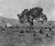 |
Women and men sitting under a tree near their camp. | P0068 Dick Beck Photograph Collection | P0068 n 08 |
| 63 |
 |
Man sitting in the shade near his tent in southern Utah. | P0068 Dick Beck Photograph Collection | P0068 n 09 |
| 64 |
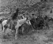 |
Five men on saddle horses in southern Utah. | P0068 Dick Beck Photograph Collection | P0068 n 10 |
| 65 |
 |
Men standing next to a fenced area containing beehives in Bluff, Utah. One man is wearing a protective head covering used while collecting honey. | P0068 Dick Beck Photograph Collection | P0068 n 11 |
| 66 |
 |
Fruita, Utah. | P0899 Arthur Ingelsby Photograph Collection | P0899n157 |
| 67 |
 |
Fruita, Utah. | P0899 Arthur Ingelsby Photograph Collection | P0899n158 |
| 68 |
 |
Fruita, Utah. | P0899 Arthur Ingelsby Photograph Collection | P0899n159 |
| 69 |
 |
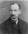
Portrait of A.H. Thompson. | P0899 Arthur Ingelsby Photograph Collection | P0899n162 |
| 70 |
 |
Horse team pulling Fresno scraper? Building a railroad? | P0077 Green River, Utah Photograph Collection | p0077n01_01_02 |
| 71 |
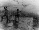 |
Three men, one woman near the river; two men have guns. | P0077 Green River, Utah Photograph Collection | p0077n01_01_03 |
| 72 |
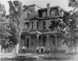 |
Palmer House | P0077 Green River, Utah Photograph Collection | p0077n01_03_13 |
| 73 |
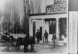 |
J.T. Farrer Store--this side of river after 1883. Poeple in picture: in buggy, back L to R: Alta Larsen, Eva Farrer; front of buggy: Amasa Larsen, Mrs. J.T. Farrer, George farrer; on porch: John Loveridge, J.T. Farrer; on bicycle: Ernest Farrer. | P0077 Green River, Utah Photograph Collection | p0077n01_05_25 |
| 74 |
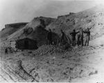 |
Early mining and some sort of mining apparatus | P0077 Green River, Utah Photograph Collection | p0077n01_08_44 |
| 75 |
 |
J.T. Farrer | P0077 Green River, Utah Photograph Collection | p0077n01_09_50 |
| 76 |
 |
Tom Farrer | P0077 Green River, Utah Photograph Collection | p0077n01_09_51 |
| 77 |
 |
Charles Swasey | P0077 Green River, Utah Photograph Collection | p0077n01_09_56 |
| 78 |
 |
Lily Tomilson (with baby) | P0077 Green River, Utah Photograph Collection | p0077n01_09_57 |
| 79 |
 |
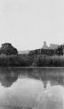
The Amphitheater | P0085 Green River Photograph Collection | p0085n01_01_01 |
| 80 |
 |
The Amphitheater | P0085 Green River Photograph Collection | p0085n01_01_02 |
| 81 |
 |
Mouth of Three Canyons | P0085 Green River Photograph Collection | p0085n01_01_03 |
| 82 |
 |
Bowknot Bend | P0085 Green River Photograph Collection | p0085n01_01_04 |
| 83 |
 |
Bowknot Bend, about 75 miles before Green River | P0085 Green River Photograph Collection | p0085n01_01_05 |
| 84 |
 |
Above Bowknot Bend, Labyrinth Canyon, Green River | P0085 Green River Photograph Collection | p0085n01_01_06 |
| 85 |
 |
Bowknot Bend, Labyrinth Canyon, Green River | P0085 Green River Photograph Collection | p0085n01_01_07 |
| 86 |
 |
Domes of the Labyrinth, Green River | P0085 Green River Photograph Collection | p0085n01_01_08 |
| 87 |
 |
Butte of the Cross (Cresent Cross), Green River | P0085 Green River Photograph Collection | p0085n01_01_09 |
| 88 |
 |
Dellenbaugh Bute (also known as "Anvil Bute"), Labyrinth Canyon, upper end , Green River | P0085 Green River Photograph Collection | p0085n01_01_10 |
| 89 |
 |
Turks (sic) Point/ Turks Head, Stillwater Canyon, Green River | P0085 Green River Photograph Collection | p0085n01_01_11 |
| 90 |
 |
Turks Point | P0085 Green River Photograph Collection | p0085n01_01_12 |
| 91 |
 |
Neroes (sic) Head | P0085 Green River Photograph Collection | p0085n01_01_13 |
| 92 |
 |
Devils Water Jug, Grand Canyon, Utah | P0085 Green River Photograph Collection | p0085n01_01_14 |
| 93 |
 |
Cliff Dwelling | P0085 Green River Photograph Collection | p0085n01_01_15 |
| 94 |
 |
Cliff Dwelling | P0085 Green River Photograph Collection | p0085n01_01_16 |
| 95 |
 |
Colorado River, 2-3 miles below Potash Boat Ramp | P0085 Green River Photograph Collection | p0085n01_01_17 |
| 96 |
 |
Green River | P0085 Green River Photograph Collection | p0085n01_01_18 |
| 97 |
 |
Stillwater Canyon, Green River | P0085 Green River Photograph Collection | p0085n01_01_19 |
| 98 |
 |
Different veiws labeled Grand Canyon, Utah | P0085 Green River Photograph Collection | p0085n01_01_20 |
| 99 |
 |
Different veiws labeled Grand Canyon, Utah | P0085 Green River Photograph Collection | p0085n01_01_21 |
| 100 |
 |
Different veiws labeled Grand Canyon, Utah | P0085 Green River Photograph Collection | p0085n01_01_22 |