|
|
Title | Collection Number And Name | Photo Number |
| 1 |
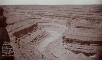 |
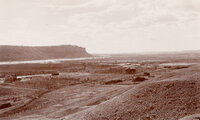
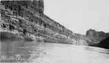
"General view of San Juan River Canyon, Utah at Mendenhall's camp. 1000 feet deep." | P0068 Dick Beck Photograph Collection | P0068 n 046 |
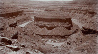
| 2 |
 |
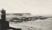
"Goose-neck Loop, San Juan River Canyon, 33 miles west of Bluff, Utah. Three miles around Loop and 1000 feet deep." | P0068 Dick Beck Photograph Collection | P0068 n 045 |
| 3 |
 |
"Grand Gulch near junction with San Juan River. 600 feet deep." | P0068 Dick Beck Photograph Collection | P0068 n 062 |
| 4 |
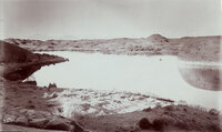 |
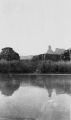
"Hermit Lake in western San Juan Co., Utah. 12 miles east of Colorado River, 1/4 mile wide and 1/2 mile long. The Henry Mountains, faintly seen, 75 miles distant." This lake was on the famous Hole-in-the-Rock trail. The natural dam failed in 1914? The lake no longer exists. | P0068 Dick Beck Photograph Collection | P0068 n 023 |
| 5 |
 |
"Looking southwest from Bluff, Utah." | P0068 Dick Beck Photograph Collection | P0068 n 063 |
| 6 |
 |
"Looking southwest from Bluff, Utah." | P0068 Dick Beck Photograph Collection | P0068 n 064 |
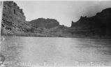
| 7 |
 |
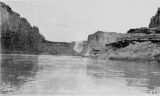
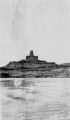
"Mexican Hat on the San Juan River at Wilson's Camp." | P0068 Dick Beck Photograph Collection | P0068 n 065 |
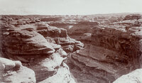
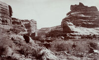
| 8 |
 |
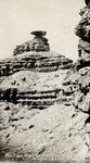
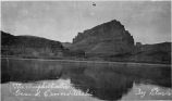
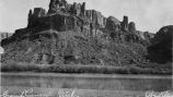
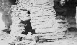
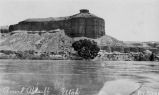
"Mokee Castle, Grand Gulch, San Juan County, Utah. Around its base and under its sheltering cliffs were found many relics of the old cliff-dwellers." | P0068 Dick Beck Photograph Collection | P0068 n 061 |
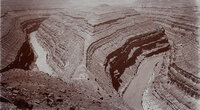
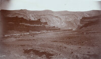
| 9 |
 |
"Mound Loop, San Juan River Canyon. Scene in oil field 30 miles west of Bluff, Utah. Two miles around loop and 800 feet deep." | P0068 Dick Beck Photograph Collection | P0068 n 044 |
| 10 |
 |
"Some rocks, Bluff, Utah. Blue lime forms the background while deep shaded parts are red lime ot trias rocks. View from San Juan Oil Field." | P0068 Dick Beck Photograph Collection | P0068 n 024 |
| 11 |
 |
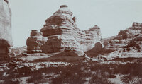
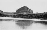
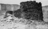
"Victoria Camp, Grand Gulch, San Juan County, Utah. Queen Vic's profiled is seen on top of cliff, right side." | P0068 Dick Beck Photograph Collection | P0068 n 060 |
| 12 |
 |
Above Bowknot Bend, Labyrinth Canyon, Green River | P0085 Green River Photograph Collection | p0085n01_01_06 |
| 13 |
 |
The Amphitheater | P0085 Green River Photograph Collection | p0085n01_01_01 |
| 14 |
 |
The Amphitheater | P0085 Green River Photograph Collection | p0085n01_01_02 |
| 15 |
 |
Bowknot Bend | P0085 Green River Photograph Collection | p0085n01_01_04 |
| 16 |
 |
Bowknot Bend, about 75 miles before Green River | P0085 Green River Photograph Collection | p0085n01_01_05 |
| 17 |
 |
Bowknot Bend, Labyrinth Canyon, Green River | P0085 Green River Photograph Collection | p0085n01_01_07 |
| 18 |
 |
Butte of the Cross (Cresent Cross), Green River | P0085 Green River Photograph Collection | p0085n01_01_09 |
| 19 |
 |
Buttes of the Cross | P0085 Green River Photograph Collection | p0085n01_01_37 |
| 20 |
 |
Charles Swasey | P0077 Green River, Utah Photograph Collection | p0077n01_09_56 |
| 21 |
 |
Cliff Dwelling | P0085 Green River Photograph Collection | p0085n01_01_16 |
| 22 |
 |
Cliff Dwelling | P0085 Green River Photograph Collection | p0085n01_01_15 |
| 23 |
 |
Colorado River, 2-3 miles below Potash Boat Ramp | P0085 Green River Photograph Collection | p0085n01_01_17 |
| 24 |
 |
David McPherson (1847-1898), father of Jim McPherson | P0821 Don and Jeanette Wilcox Photograph Collection | p0821n1_06_01 |
| 25 |
 |
Dellenbaugh Bute (also known as "Anvil Bute"), Labyrinth Canyon, upper end , Green River | P0085 Green River Photograph Collection | p0085n01_01_10 |