Home
Browse
Ask Us
Chat
Harmful Language Statement
Log in
Photo Archives
Advanced Search
About
Over 70,000 photos covering a variety of topics from Marriott Library Special Collections
Year
1922
1923
1924
1925
1926
1927
1928
1929
1930
1931
1932
1933
TO
1922
1923
1924
1925
1926
1927
1928
1929
1930
1931
1932
1933
Type
Image/StillImage
12
Format
image/jpeg
12
Collection
Photo Archives
12
Filters:
Collection Name:
"Utah Flood Survey"
1
-
25
of
12
Gallery view
Number of results to display per page
10
25
50
100
200
Sort by Relevance
Sort by Title A-Z
Sort by Title Z-A
Sort by Date Ascending
Sort by Date Descending
Sort by Last Modified Ascending
Sort by Last Modified Descending
Title
Date
Type
1
Shoal Creek Dam : Excavation for Shoal Creek diversion dam above Enterprise [and] The same after dam was finally completed
1930; 1931; 1932
Image/StillImage
2
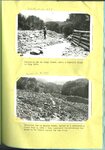
Diversion dam on Canal Creek, after a terrific flood in July 1922 [and] Diversion dam on Haights Creek, buried by a devastating flood July 3, 1926
1922; 1926
Image/StillImage
3
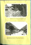
Shoal Creek Dam : Looking up stream through spillway of Shoal Creek diversion dam [and] The same looking down stream
1930; 1931; 1932
Image/StillImage
4
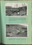
Summit Flood Control Dam : Constructing flood control diversion dam at Summit [and] The same after completion and after a terrific summer flood carrying boulders weighing tons each
1930; 1931; 1932
Image/StillImage
5
Enterprise flood dam in process of construction
1924; 1925; 1926
Image/StillImage
6
Haights Creek Diversion dam in process of construction
1923; 1924; 1925; 1926; 1927; 1928; 1929; 1930; 1931; 1932; 1933
Image/StillImage
7
Diversion dam above Orderville [and] Diversion dam above Escalante in Potato Valley
1930; 1931; 1932
Image/StillImage
8
Flooding in Willard, Utah : "beaver dam" built by man to divert the stream (Willard Creek) into the barrier basin [and] Temporary spillway just above highway crossing
1924; 1925
Image/StillImage
9
Shoal Creek Dam : Equalizing reservoir no. 1 on Shoal Creek [and] Equalizing reservoir no. 2 on Shoal Creek
1930; 1931; 1932
Image/StillImage
10
Woodruff spillway : Woodruff equalizing reservoir, showing first construction camp, 1926, and beginning of the new dam [and] Woodruff spillway at the height of 24 ft., which was the first level reached
1926
Image/StillImage
11
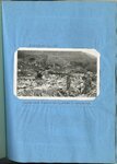
Bingham was also severely hit by flood and fire [and] Weber Canyon, Aug. 1930, looking down stream where torrential flood carried a dam completely across the river, forcing the stream to flow down the highway
1930
Image/StillImage
12
Kessler Canyon barrier spillway : building an equalizing check above intake to tunnel through Garfield Smelter [and] Constructing a check dam in Kessler Canyon below main structure
1923; 1924; 1925; 1926; 1927; 1928; 1929; 1930; 1931; 1932; 1933
Image/StillImage
1
-
25
of
12