Home
Browse
Ask Us
Chat
Harmful Language Statement
Log in
Photo Archives
Advanced Search
About
Over 70,000 photos covering a variety of topics from Marriott Library Special Collections
Year
1921
1922
1923
1924
1925
1926
1927
1928
1929
1930
1931
1932
1933
TO
1921
1922
1923
1924
1925
1926
1927
1928
1929
1930
1931
1932
1933
Type
Image/StillImage
59
Format
image/jpeg
59
Collection Name
Utah Flood Survey
59
Filters:
Collection Name:
"Utah Flood Survey"
Collection:
uum_map
1
-
25
of
59
<
1
2
3
>
Gallery view
Number of results to display per page
10
25
50
100
200
Sort by Relevance
Sort by Title A-Z
Sort by Title Z-A
Sort by Date Ascending
Sort by Date Descending
Sort by Last Modified Ascending
Sort by Last Modified Descending
Sort by Photo Number
Title
Setname
Type
1
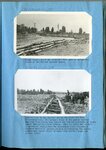
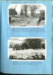
Erosion, North Salt Lake 1932 [and] Erosion west of Salt Lake, on north point of Oquirrh Mountains
uum_map
Image/StillImage
2
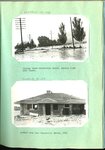
Flooding in Willard, Utah : scenes along Main Street, Willard, following the flood of August 13, 1923
uum_map
Image/StillImage
3
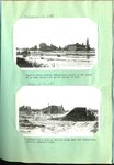
Flooding in Willard, Utah : looking down Main Street, Willard, from the north end of the town, August 18, 1923 [and] Barn containing livestock, automobile trucks and 75 tons of hay, carried 1/4 mile and deposited on Main Street
uum_map
Image/StillImage
4
Flooding in Willard, Utah : site of the Willard flood barrier, Septembre 3, 1923 [and] same May 10, 1924, two days after construction began.
uum_map
Image/StillImage
5
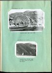
Flooding in Willard, Utah : Willard barrier basin in 1925
uum_map
Image/StillImage
6
Flooding in Willard, Utah : Willard barrier at the close of the second high water season following control, June 1926 [and] A closeup of the spillway, same date
uum_map
Image/StillImage
7
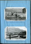
Flooding in Willard, Utah : Interior of the new barrier basin, June 1925 [and] Raising the outer bank still higher, July 1926, just previous to summer flood.
uum_map
Image/StillImage
8
Flooding in Willard, Utah : Closing an opening through one of the central deflectors at upper end of Willard barrier basin [and] Southwest corner of Willard barrier, July 20, 1925, during the second season of operation
uum_map
Image/StillImage
9
Flooding in Willard, Utah : Timber, coarse straw and boulders used to define the limits of the Willard barrier basin [and] Another view of the barrier during the first few days of construction
uum_map
Image/StillImage
10
Flooding in Willard, Utah : "beaver dam" built by man to divert the stream (Willard Creek) into the barrier basin [and] Temporary spillway just above highway crossing
uum_map
Image/StillImage
11
Flooding in Willard, Utah : Emergency highway crossing of flood control channel, with teams at work endeavoring to keep the channel open [date] [and] the same 5 days later
uum_map
Image/StillImage
12
Flooding in Willard, Utah : Railroad crossing at Willard Creek 2 days after stream was placed under control [and] crib and rock protection in Willard Canyon beneath a 75 foot bank of gravel
uum_map
Image/StillImage
13
Farmington floods : Farmington flood barrier in its early stages of development [and] The same successfully controlling a heavy torrential flood on July 3, 1925
uum_map
Image/StillImage
14
Farmington floods : Farmington spillway following a torrential flood [ad] Debris deposited above the Farmington barrier by the flood of July 3, 1926
uum_map
Image/StillImage
15
Farmington floods : Farmington spillway of rubble-concrete during the first season of operation, April 1925 [and] The same in 1927
uum_map
Image/StillImage
16
Farmington floods : Farmington flood barrier at the close of a season of excessive high water [and] Looking up stream from spillway into Farmington barrier basin
uum_map
Image/StillImage
17
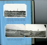
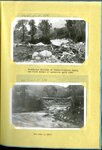
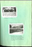
Ford Creek floods : Ford Creek, Davis County, after the third torrential flood in recent years
uum_map
Image/StillImage
18
Ford Creek floods : Result of and flow from torrential flood, Ford Creek, August 13, 1923 [and] The disaster of 1923 repeated on Ford Creek in a series of three floods in 1930
uum_map
Image/StillImage
19
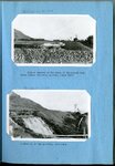
Ford Creek floods : Ford Creek in 1924 following 1923 floods [and] Looking across state highway at Ford Creek following 1930 flood
uum_map
Image/StillImage
20
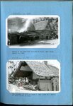
Parrish Creek and Centerville flooding : Parrish Creek showing Centerville school in the midst of an area devastated by the floods of 1930 [and] Remnants of a home on Parrish Creek near the Centerville school, September 1930
uum_map
Image/StillImage
21
Parrish Creek and Centerville flooding : Highway below Centerville School, Parrish Creek 1930 floods [and] Another home near Centerville School 1930
uum_map
Image/StillImage
22
Parrish Creek and Centerville flooding : Two pictures showing consistency of mud flows in Davis County floods
uum_map
Image/StillImage
23
Digging the state highway out after a typical Davis County flood [and] A minor flood from Steed Creek blocked the highway as indicated
uum_map
Image/StillImage
24
Highway fo Steed Creek crossing during torrential flood, looking upstream [and] A woven wire fence parallel to direction of flow held a torrential flood within bounds, just above highway crossing at Fiddler's Creek near Cedar City
uum_map
Image/StillImage
25
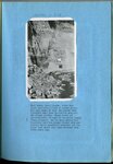
Bingham was also severely hit by flood and fire [and] Weber Canyon, Aug. 1930, looking down stream where torrential flood carried a dam completely across the river, forcing the stream to flow down the highway
uum_map
Image/StillImage
1
-
25
of
59
<
1
2
3
>