Home
Browse
Ask Us
Chat
Harmful Language Statement
Log in
Photo Archives
Advanced Search
About
Over 70,000 photos covering a variety of topics from Marriott Library Special Collections
Year
1921
1922
1923
1924
1925
1926
1927
1928
1929
1930
1931
1932
1933
TO
1921
1922
1923
1924
1925
1926
1927
1928
1929
1930
1931
1932
1933
Type
Image/StillImage
32
Format
image/jpeg
32
Collection
Photo Archives
32
Filters:
Collection Name:
"Utah Flood Survey"
Date:
"1930"
1
-
25
of
32
<
1
2
>
Gallery view
Number of results to display per page
10
25
50
100
200
Sort by Relevance
Sort by Title A-Z
Sort by Title Z-A
Sort by Date Ascending
Sort by Date Descending
Sort by Last Modified Ascending
Sort by Last Modified Descending
Title
Date
Type
1
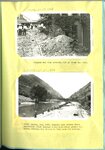
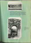
Bingham was also severely hit by flood and fire [and] Weber Canyon, Aug. 1930, looking down stream where torrential flood carried a dam completely across the river, forcing the stream to flow down the highway
1930
Image/StillImage
2
Chalk Creek before control, looking up stream during period of highwater in spring, when stream was carrying large quantities of gravel [and] Looking up stream across north end of Fillmore barrier, first season of operation
1923; 1924; 1925; 1926; 1927; 1928; 1929; 1930; 1931; 1932; 1933
Image/StillImage
3
Chalk Creek flooding : Chalk Creek before control in 1921 [and] Chalk Creek barrier and spillway which for ten years has successfully controlled floods
1921; 1930
Image/StillImage
4
Digging the state highway out after a typical Davis County flood [and] A minor flood from Steed Creek blocked the highway as indicated
1930; 1931; 1932
Image/StillImage
5
Diversion dam above Orderville [and] Diversion dam above Escalante in Potato Valley
1930; 1931; 1932
Image/StillImage
6
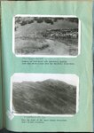
Erosion of foot hills near Bountiful, showing goat herd which grazes over the Bountiful water-shed [and] Near the crest of the Davis County water-shed where floods originate
1923; 1924; 1925; 1926; 1927; 1928; 1929; 1930; 1931; 1932; 1933
Image/StillImage
7
Erosion on Santa Clara Creek : an attempt at control on Santa Clara Creek
1923; 1924; 1925; 1926; 1927; 1928; 1929; 1930; 1931; 1932; 1933
Image/StillImage
8
Erosion on Santa Clara Creek is a problem of great concern to the farmers of St. George and Santa Clara
1923; 1924; 1925; 1926; 1927; 1928; 1929; 1930; 1931; 1932; 1933
Image/StillImage
9
Flooding in Willard, Utah : Emergency highway crossing of flood control channel, with teams at work endeavoring to keep the channel open [date] [and] the same 5 days later
1930; 1931; 1932
Image/StillImage
10
Ford Creek floods : Ford Creek in 1924 following 1923 floods [and] Looking across state highway at Ford Creek following 1930 flood
1924; 1930
Image/StillImage
11
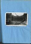
Ford Creek floods : Ford Creek, Davis County, after the third torrential flood in recent years
1930
Image/StillImage
12
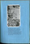
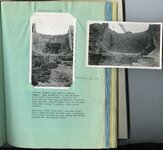
Ford Creek floods : Result of and flow from torrential flood, Ford Creek, August 13, 1923 [and] The disaster of 1923 repeated on Ford Creek in a series of three floods in 1930
1923; 1930
Image/StillImage
13
Haights Creek Diversion dam in process of construction
1923; 1924; 1925; 1926; 1927; 1928; 1929; 1930; 1931; 1932; 1933
Image/StillImage
14
Highway fo Steed Creek crossing during torrential flood, looking upstream [and] A woven wire fence parallel to direction of flow held a torrential flood within bounds, just above highway crossing at Fiddler's Creek near Cedar City
1930; 1931; 1932
Image/StillImage
15
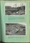
Kessler Canyon barrier spillway : building an equalizing check above intake to tunnel through Garfield Smelter [and] Constructing a check dam in Kessler Canyon below main structure
1923; 1924; 1925; 1926; 1927; 1928; 1929; 1930; 1931; 1932; 1933
Image/StillImage
16
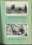
Kessler Canyon barrier spillway : Guniting a rubble-concrete wing wall, Kessler Canyon [and] Gasoline driven shovel building the flood barrier, Kessler Canyon
1923; 1924; 1925; 1926; 1927; 1928; 1929; 1930; 1931; 1932; 1933
Image/StillImage
17
Kessler Canyon barrier spillway : Lifting boulders out of the ground for use in building main spillway, Kessler Canyon [and] Boulders being placed by heavy derrick, in foundation of main spillway, Kessler Canyon
1923; 1924; 1925; 1926; 1927; 1928; 1929; 1930; 1931; 1932; 1933
Image/StillImage
18
Kessler Canyon barrier spillway : looking down stream from main spillway, Kessler Canyon [and] Detail of rubble-concrete construction
1923; 1924; 1925; 1926; 1927; 1928; 1929; 1930; 1931; 1932; 1933
Image/StillImage
19
Kessler Canyon barrier spillway : looking up stream from Garfield smelter at series of control structures in Kessler Canyon [and] Looking down stream across site of main barrier spillway, Kessler Canyon, during construction
1923; 1924; 1925; 1926; 1927; 1928; 1929; 1930; 1931; 1932; 1933
Image/StillImage
20
Kessler Canyon barrier spillway : spillway through man barrier, Kessler Canyon [and] The flood stream drops over a circular crest into a stilling pond
1923; 1924; 1925; 1926; 1927; 1928; 1929; 1930; 1931; 1932; 1933
Image/StillImage
21
Kessler Canyon barrier spillway looking downstream toward Garfield smelter [and] The same after a forrential flood which reached a depth of 7 feet over the 70 foot crest
1923; 1924; 1925; 1926; 1927; 1928; 1929; 1930; 1931; 1932; 1933
Image/StillImage
22
Kessler Canyon main spillway structure
1923; 1924; 1925; 1926; 1927; 1928; 1929; 1930; 1931; 1932; 1933
Image/StillImage
23
Manti barrier at the close of the high water season [and] Manti barrier spillway in operation
1923; 1924; 1925; 1926; 1927; 1928; 1929; 1930; 1931; 1932; 1933
Image/StillImage
24
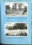
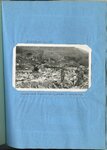
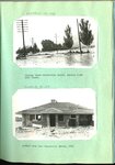
Parrish Creek and Centerville flooding : Highway below Centerville School, Parrish Creek 1930 floods [and] Another home near Centerville School 1930
1930
Image/StillImage
25
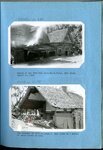
Parrish Creek and Centerville flooding : Parrish Creek showing Centerville school in the midst of an area devastated by the floods of 1930 [and] Remnants of a home on Parrish Creek near the Centerville school, September 1930
1930
Image/StillImage
1
-
25
of
32
<
1
2
>