Home
Browse
Ask Us
Chat
Harmful Language Statement
Log in
Advanced Search
Year
1872
1873
1874
1875
1876
1877
1878
1879
1880
1881
1882
1883
1884
1885
1886
1887
1888
1889
1890
1891
1892
1893
1894
1895
1896
1897
1898
1899
1900
1901
1902
1903
1904
1905
1906
1907
1908
1909
1910
1911
1912
1913
1914
1915
1916
1917
1918
1919
1920
1921
1922
1923
1924
1925
1926
1927
1928
1929
1930
1931
1932
1933
1934
1935
1936
1937
1938
1939
1940
1941
1942
1943
1944
1945
1946
1947
1948
1949
1950
1951
1952
1953
1954
1955
1956
1957
1958
1959
1960
1961
1962
1963
1964
1965
1966
1967
1968
1969
1970
1971
1972
1973
1974
1975
1976
1977
1978
1979
1980
1981
1982
1983
1984
1985
1986
1987
1988
1989
1990
1991
1992
1993
TO
1872
1873
1874
1875
1876
1877
1878
1879
1880
1881
1882
1883
1884
1885
1886
1887
1888
1889
1890
1891
1892
1893
1894
1895
1896
1897
1898
1899
1900
1901
1902
1903
1904
1905
1906
1907
1908
1909
1910
1911
1912
1913
1914
1915
1916
1917
1918
1919
1920
1921
1922
1923
1924
1925
1926
1927
1928
1929
1930
1931
1932
1933
1934
1935
1936
1937
1938
1939
1940
1941
1942
1943
1944
1945
1946
1947
1948
1949
1950
1951
1952
1953
1954
1955
1956
1957
1958
1959
1960
1961
1962
1963
1964
1965
1966
1967
1968
1969
1970
1971
1972
1973
1974
1975
1976
1977
1978
1979
1980
1981
1982
1983
1984
1985
1986
1987
1988
1989
1990
1991
1992
1993
Type
Image
3,521
Image/StillImage
143
Format
image/jpeg
3,594
application/pdf
70
Collection
Photo Archives
3,521
UAIDA Main Collection
143
Filters:
Collection Name:
"Herbert E. Gregory"
51
-
75
of
3,664
<
1
2
3
4
5
6
7
8
9
10
>
Gallery view
Number of results to display per page
10
25
50
100
200
Sort by Relevance
Sort by Title A-Z
Sort by Title Z-A
Sort by Date Ascending
Sort by Date Descending
Sort by Last Modified Ascending
Sort by Last Modified Descending
Title
Date
Type
Setname
51
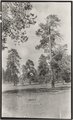
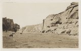
Top of plateau between St. Michaels and Ganado, Ariz. Trees are yellow pines, 1909 (photo G-33)
1909
Image
uum_map
52
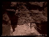
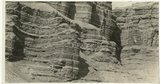
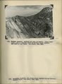
Unconformity
1911
Image
uum_map
53
Unconformity, McElmo (?) on La Plata (?) or in 2± mil. southwest of Sunrise Spgs., Arizona (photo G-43)
1909
Image
uum_map
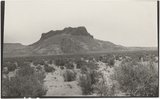
54
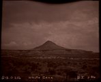
White Cone (Photo G256)
1911
Image
uum_map
55
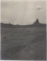
Zilh-Tusayan, igneous mass, 20± mi. northwest of Fort Defiance, Arizona, 1909 (photo G-20)
1909
Image
uum_map
56
Agathla and Slim (Queen) Rock, Ariz., from S.E. (Photo G144)
1910
Image
uum_map
57
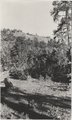
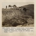
Trail, bare rock, wind-swept steep slopes, between Beaver and Junction canyons, north of Navajo Mt., Utah, 1910 (Photo G172)
1910
Image
uum_map
58
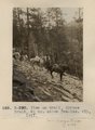
View on trail, Spruce Brook, 5+ mi. above Tsa-lee. VII, 1911 (Photo G-290)
1911
Image
uum_map
59
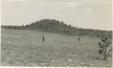
Dr. Pogue on Greybird, 1910
1910
Image
uum_map
60
Camp 3+ mi. east of Agathla Needle, Ariz. (Photo N-M93)
1910
Image
uum_map
61
Camp at base of Baigaiche Mt. VI, 45. 1911 (Photo N-M113)
1911
Image
uum_map
62
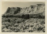
Canyon de Chelly. Shinarump capping Permian (Photo G373)
1913
Image
uum_map
63
Bowers Knoll; Volcano viewed from northwest. Garfield County, UT. 1944
1944
Image
uum_map
64
Cretaceous shales (tropic formation). Antimony Canyon, Garfield County, UT. 1943
1943
Image
uum_map
65
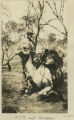
H.E.G. and "Bubbles"
1916
Image
uum_map
66
Herbert E. Gregory Book 12: Colorado Plateau, Province, 1942-1944
1942; 1943; 1944
Image
uum_map
67
West wall of Seaman Wash
1944
Image
uum_map
68
Basalt-capped mesa on Dolores (Triassic), 6± miles south of Beddehoche (Indian Wells), Ariz., 1909 (photo G-67)
1909
Image
uum_map
69
Basalt-capped mesa on Dolores (Triassic), 8± miles south of Beddehoche, Ariz., 1909 (photo G-68)
1909
Image
uum_map
70
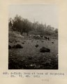
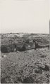
Beautiful Valley." Fossil forest (Dolores strata), 12± mi. north of Ganado, Ariz. All pebbles in foreground are petrified wood, 1909 (photo G-28)
1909
Image
uum_map
71
Beautiful Valley." Fossil forest, Dolores strata, petrified log, 1909 (photo G-29)
1909
Image
uum_map
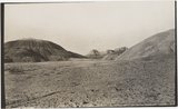
72
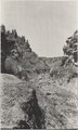
Buells Park, 12± mi. north of Ft. Defiance, Ariz. Canyon at outlet, 1909 (photo G-26)
1909
Image
uum_map
73
Same as G-72, nearer view: a volcanic neck, northwest of Chandler's Ranch (photo G-73)
1909
Image
uum_map
74
Top of plateau near Sawmill, 16± mi. northwest of Fort Defiance, Ariz. Trees are yellow pines and scrup oaks, 1909 (photo G-22)
1909
Image
uum_map
75
Twin Buttes south of Biddehoche, Arizona, looking west, 1909 (photo G-60)
1909
Image
uum_map
51
-
75
of
3,664
<
1
2
3
4
5
6
7
8
9
10
>