Home
Browse
Ask Us
Chat
Harmful Language Statement
Log in
Photo Archives
Advanced Search
About
Over 70,000 photos covering a variety of topics from Marriott Library Special Collections
Year
1872
1873
1874
1875
1876
1877
1878
1879
1880
1881
1882
1883
1884
1885
1886
1887
1888
1889
1890
1891
1892
1893
1894
1895
1896
1897
1898
1899
1900
1901
1902
1903
1904
1905
1906
1907
1908
1909
1910
1911
1912
1913
1914
1915
1916
1917
1918
1919
1920
1921
1922
1923
1924
1925
1926
1927
1928
1929
1930
1931
1932
1933
1934
1935
1936
1937
1938
1939
1940
1941
1942
1943
1944
1945
1946
1947
1948
1949
1950
1951
1952
1953
1954
1955
1956
1957
1958
1959
1960
1961
1962
1963
1964
1965
1966
1967
1968
1969
1970
1971
1972
1973
1974
1975
1976
1977
1978
1979
1980
1981
1982
1983
1984
1985
1986
1987
1988
1989
1990
1991
1992
1993
TO
1872
1873
1874
1875
1876
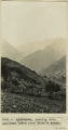
1877
1878
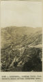
1879
1880
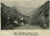
1881
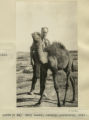
1882
1883
1884
1885
1886
1887
1888
1889
1890
1891
1892
1893
1894
1895
1896
1897
1898
1899
1900
1901
1902
1903
1904
1905
1906
1907
1908
1909
1910
1911
1912
1913
1914
1915
1916
1917
1918
1919
1920
1921
1922
1923
1924
1925
1926
1927
1928
1929
1930
1931
1932
1933
1934
1935
1936
1937
1938
1939
1940
1941
1942
1943
1944
1945
1946
1947
1948
1949
1950
1951
1952
1953
1954
1955
1956
1957
1958
1959
1960
1961
1962
1963
1964
1965
1966
1967
1968
1969
1970
1971
1972
1973
1974
1975
1976
1977
1978
1979
1980
1981
1982
1983
1984
1985
1986
1987
1988
1989
1990
1991
1992
1993
Type
Image
3,451
Format
image/jpeg
3,451
Collection
Photo Archives
3,451
Filters:
Collection Name:
"Herbert E. Gregory"
Type:
"Image"
Format:
image
Setname:
!(ir* OR ehsl*)
126
-
150
of
3,451
<
1
2
3
4
5
6
7
8
9
10
>
Gallery view
Number of results to display per page
10
25
50
100
200
Sort by Relevance
Sort by Title A-Z
Sort by Title Z-A
Sort by Date Ascending
Sort by Date Descending
Sort by Last Modified Ascending
Sort by Last Modified Descending
Title
Date
Type
126
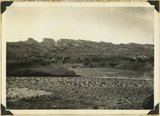
Aspen forest, branch of Sevier River, east of Cedar Breaks, Kane County, Utah, 1930.
1930
Image
127
Aspens on Elk Ridge
1907
Image
128
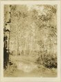
At Grand View
1900
Image
129
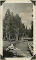
At the River
1900
Image
130
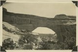
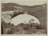
Augusta Bridge, Bridges National Monument, UT. 1925
1925
Image
131
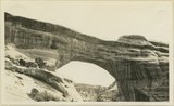
Augusta Bridge, White Canyon, (Coconino?) Chas. Goodman, 1907
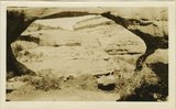
1907
Image
132
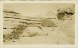
Augusta Bridge, White Canyon, 1924
1924
Image
133
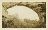
Augusta Bridge, White Canyon, Coconino sandstone
1907
Image
134
Augusta Bridge, White Canyon, Coconino sandstone
1907
Image
135
Augusta Bridge, White Canyon, Coconino sandstone
1907
Image
136
Augusta Bridge, White Canyon, Coconino sandstone
1907
Image
137
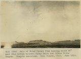
Axis of Water Pocket Fold looking south 30 degrees west from divide between Muley Twist and Silver Falls Canyon. Wingate sandstone. Kane County, UT. June 1918
1918
Image
138
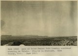
Axis of Water Pocket Fold looking southwest standing on Chinle. Wingate in distance. Kane County, UT. June 1918
1918
Image
139
Ayusbamba. General view of lake beds looking SE.
1912; 1913; 1914; 1915
Image
140
Ayusbamba. Looking down Apurimac Caffon from Calvo's house.
1912; 1913; 1914; 1915
Image
141
Ayusbamba. Looking north from Calvo's house across limestone mass.
1912; 1913; 1914; 1915
Image
142
Ayusbamba. Senor and Senora Calvo at dining-room door.
1912
Image
143
Ayusbamba. View SW from same place 1/4 N. Ely from Taray.
1912
Image
144
Baby camel, Central Australia, 1916
1916
Image
145
Baby Llamas.
1911
Image
146
The back slopes of Capitol Reef, viewed from the summit of the Fruita-Cainesville road 1/2 mile west of Pleasant Creek. Navajo, Carmel, and red gypsiferous shale above the Carmel in middle foreground, crest of roof on horizon. Wayne County, Utah, 1937.
1937
Image
147
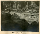
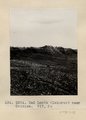
Bad Lands (Dolores) near Chinlee. VII, 26 (Photo G271)
1911
Image
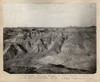
148
Bad lands, Chinle strata in Hopi Buttes region, north east of Holbrook, Ariz. USGS, probably Darton
1911
Image
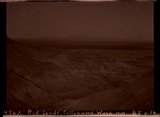
149
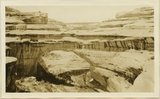
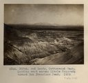
Bad Lands, Cottonwood Wash. 1909
1911
Image
150
Bad Lands, Cottonwood Wash. 1909 (photograph from Herbert E. Gregory Book 5: Navajo, 1911)
1911
Image
126
-
150
of
3,451
<
1
2
3
4
5
6
7
8
9
10
>