Home
Browse
Ask Us
Chat
Harmful Language Statement
Log in
Photo Archives
Advanced Search
About
Over 70,000 photos covering a variety of topics from Marriott Library Special Collections
Year
1875
1876
1877
1878
1879
1880
1881
1882
1883
1884
1885
1886
1887
1888
1889
1890
1891
1892
1893
1894
1895
1896
1897
1898
1899
1900
1901
1902
1903
1904
1905
1906
1907
1908
1909
1910
1911
1912
1913
1914
1915
1916
1917
1918
1919
1920
1921
1922
1923
1924
1925
1926
1927
1928
1929
1930
1931
1932
1933
1934
1935
1936
1937
1938
1939
1940
1941
1942
1943
1944
1945
1946
1947
1948
1949
1950
1951
1952
1953
1954
1955
1956
1957
1958
1959
1960
1961
1962
1963
1964
1965
1966
1967
1968
1969
1970
1971
1972
1973
1974
1975
1976
1977
1978
1979
1980
1981
1982
1983
1984
1985
1986
1987
1988
1989
1990
1991
1992
1993
TO
1875
1876
1877
1878
1879
1880
1881
1882
1883
1884
1885
1886
1887
1888
1889
1890
1891
1892
1893
1894
1895
1896
1897
1898
1899
1900
1901
1902
1903
1904
1905
1906
1907
1908
1909
1910
1911
1912
1913
1914
1915
1916
1917
1918
1919
1920
1921
1922
1923
1924
1925
1926
1927
1928
1929
1930
1931
1932
1933
1934
1935
1936
1937
1938
1939
1940
1941
1942
1943
1944
1945
1946
1947
1948
1949
1950
1951
1952
1953
1954
1955
1956
1957
1958
1959
1960
1961
1962
1963
1964
1965
1966
1967
1968
1969
1970
1971
1972
1973
1974
1975
1976
1977
1978
1979
1980
1981
1982
1983
1984
1985
1986
1987
1988
1989
1990
1991
1992
1993
Type
Image
671
Format
image/jpeg
665
application/pdf
6
Collection
Photo Archives
671
Filters:
Collection Name:
"Herbert E. Gregory"
Spatial Coverage:
"San Juan County (Utah)"
76
-
100
of
671
<
1
2
3
4
5
6
7
8
9
10
>
Gallery view
Number of results to display per page
10
25
50
100
200
Sort by Relevance
Sort by Title A-Z
Sort by Title Z-A
Sort by Date Ascending
Sort by Date Descending
Sort by Last Modified Ascending
Sort by Last Modified Descending
Title
Date
Type
76
Canon south of Bridge Canon, looking west
1913
Image
77
Canon south of Bridge Canon, west of Navaho Mountain
1913
Image
78
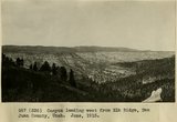
Canyon leading west from Elk Ridge, San Juan County, Utah. June, 1915.
1915
Image
79
Canyon of San Juan River from Honaker trail, San Juan Oil Field, 600 ft. below top.
1909
Image
80
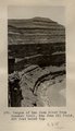
Canyon of San Juan River from Honaker trail, San Juan Oil Field. Looking north from a point 600 ft. below top. Goodridge Formation.
1909
Image
81
Carmel overlying Navajo Gray Mesa. San Juan County, UT, 1927
1927
Image
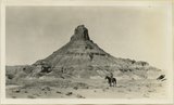
82
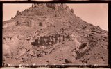
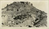
Castle Butte near mouth of Red Canyon Wingate on Chinle (showing details of Chinle beds); surrounding surface Shinarump, Zeke Johnson. San Juan County, UT, 1927
Image
83
Castle Butte near mouth of Red Canyon Wingate on Chinle; surrounding surface Shinarump, Zeke Johnson. San Juan County, UT, 1927
1927
Image
84
Castle Butte near mouth of Red Canyon Wingate on Chinle; surrounding surface Shinarump, Zeke Johnson. San Juan County, UT, 1927
1927
Image
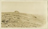
85
Castle uplift east flank, Navajo sandstone, San Juan County, UT, 1925
1925
Image
86
Castle uplift east flank, Navajo sandstone, San Juan County, UT, 1925
1925
Image
87
Castle uplift east flank, Navajo sandstone, San Juan County, UT, 1925
1925
Image
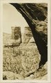
88
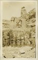
Cathedral Arch I. Arch Canyon
1920; 1921; 1922; 1923; 1924; 1925; 1926; 1927; 1928; 1929; 1930
Image
89
Cathedral Arch I. Arch Canyon
1920; 1921; 1922; 1923; 1924; 1925; 1926; 1927; 1928; 1929; 1930
Image
90
Cathedral Arch II, Arch Canyon, Coconino over Supai
1920; 1921; 1922; 1923; 1924; 1925; 1926; 1927; 1928; 1929; 1930
Image
91
Cathedral Arch II, Arch Canyon, Coconino over Supai
1920; 1921; 1922; 1923; 1924; 1925; 1926; 1927; 1928; 1929; 1930
Image
92
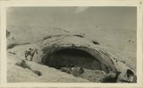
Cave in Navajo sandstone east slope Comb monocline in Butler Wash, 11 miles from mouth. San Juan County, UT, 1928
Image
93
Cave in Navajo sandstone east slope Comb monocline in Butler Wash, 11 miles from mouth. San Juan County, UT, 1928
1928
Image
94
Cave in Navajo sandstone east slope Comb monocline in Butler Wash, 11 miles from mouth. San Juan County, UT, 1928
1928
Image
95
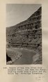
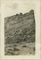
Cedar mesa looking north from edge of Johns Canyon. Coconino(?) on Supai(?). San Juan County, UT, 1928
1928
Image
96
Cedar mesa looking north from edge of Johns Canyon. Coconino(?) on Supai(?). San Juan County, UT, 1928
1928
Image
97
Cedar mesa looking north from edge of Johns Canyon. Coconino(?) on Supai(?). San Juan County, UT, 1928
1928
Image
98
Cedar Mesa, Moencopie strata, 4± mi. northwest of Goodridge, Utah (Chas. Goodman photo)
1909
Image
99
Chinle and Wingate in Stevens Valley. Branch of Indian Creek. San Juan County, UT, 1928
Image
100
Chinle and Wingate in Stevens Valley. Branch of Indian Creek. San Juan County, UT, 1928
1928
Image
76
-
100
of
671
<
1
2
3
4
5
6
7
8
9
10
>