Home
Browse
Ask Us
Chat
Harmful Language Statement
Log in
Photo Archives
Advanced Search
About
Over 70,000 photos covering a variety of topics from Marriott Library Special Collections
Year
1899
1900
1901
1902
1903
1904
1905
1906
1907
1908
1909
1910
1911
1912
1913
1914
1915
1916
1917
1918
1919
1920
1921
1922
1923
1924
1925
1926
1927
1928
1929
1930
1931
1932
1933
1934
1935
1936
1937
1938
1939
1940
1941
1942
1943
1944
TO
1899
1900
1901
1902
1903
1904
1905
1906
1907
1908
1909
1910
1911
1912
1913
1914
1915
1916
1917
1918
1919
1920
1921
1922
1923
1924
1925
1926
1927
1928
1929
1930
1931
1932
1933
1934
1935
1936
1937
1938
1939
1940
1941
1942
1943
1944
Type
Image
400
Format
image/jpeg
398
application/pdf
2
Collection
Photo Archives
400
Filters:
Collection Name:
"Herbert E. Gregory"
Spatial Coverage:
"Coconino County (Ariz.)"
Type:
"Image"
201
-
225
of
400
<
4
5
6
7
8
9
10
11
12
13
>
Gallery view
Number of results to display per page
10
25
50
100
200
Sort by Relevance
Sort by Title A-Z
Sort by Title Z-A
Sort by Date Ascending
Sort by Date Descending
Sort by Last Modified Ascending
Sort by Last Modified Descending
Title
Date
Type
201
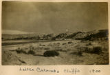
Little Colorado cliffs 1900
1900
Image
202
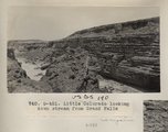
Little Colorado looking down stream from Grand Falls (Photo G421)
1913
Image
203
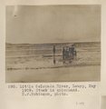
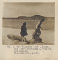
Little Colorado River, Leupp, May 1909. Stuck in quicksand. H. F. Robinson, photo.
1909
Image
204
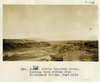
Little Colorado River, looking down stream from Government bridge, Sept. 1914
1914
Image
205
Little Colorado River, Luepp, May 1909. Mendenhall, Gregory, and Navajo. H. F. Robinson, photo.
1909
Image
206
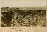
Locketts Fault in lava, 1900
1900
Image
207
Looking across Little Colorado, short distance from ????, Echo Cliffs in background
1926
Image
208
Looking across Navajo Canyon toward Navajo Mt. (Stephen Janus photo)
1910
Image
209
Looking across Navajo Canyon, Arizona, toward Navajo Mountain. La Plata strata (Stephen Janus photo, 1909)
1909
Image
210
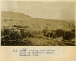
Looking east across mouth of Reservoir Canyon, Moenkopi, 1914
1914
Image
211
Looking up Bright Angel Creek from south bank, Colorado... N.P. Service photo, 1928?
1928
Image
212
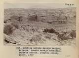
Looking up canyon of lower Kanab Creek from a point 3 miles below the mouth of Snake Gulch. AZ. 1922
1922
Image
213
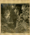
Looking up Phantom Canyon from bed of Bright Angel Creek, 1928?
1928
Image
214
Many Waters Lakes, 16± miles northeast of Leupp, Ariz., view looking west, Monument Point in distance, 1909 (photo G-85)
1909
Image
215
Many Waters, Lake and Logan, 1909
1909
Image
216
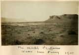
The Marble Platform near Lees Ferry 1900
1900
Image
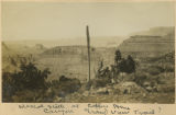
217
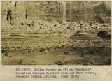
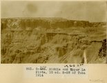
McElmo strata (?) on "Sentinal" formation, between Sentinal Rock and Warm creeks, Coconino County, Arizona, June, 1915.
1915
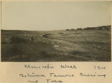
Image
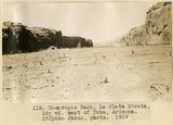
218
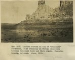
McElmo strata on top of "Sentinal" formation, view standing on Navajo sandstone between Sentinal Rock and Warm creeks, Coconino County, Arizona, June, 1915.
1915
Image
219
Mesa west of Oraibi Wash, 1900
1900
Image
220
Mescal stalk at Copper Mine Canyon, Grand View Trail?
1900
Image
221
Middle and upper La Plata, 10 mi. S-SW of Tuba, 1914
1914
Image
222
Moencopie Wash at Farm (Photo G442)
1913
Image
223
Moencopie Wash between Tanners Crossing and Tuba, 1900
1900
Image
224
Moencopie Wash, La Plata strata, 12± mi. east of Tuba, Arizona (Stephen Janus photo, 1909)
1909
Image
225
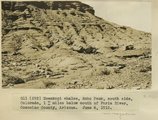
Moenkopi shales, Echo Peak, south side, Colorado, 1+ miles below mouth of Paria River, Coconino County, Arizona. June 6, 1915.
1915
Image
201
-
225
of
400
<
4
5
6
7
8
9
10
11
12
13
>