Home
Browse
Ask Us
Chat
Harmful Language Statement
Log in
Photo Archives
Advanced Search
About
Over 70,000 photos covering a variety of topics from Marriott Library Special Collections
Year
1899
1900
1901
1902
1903
1904
1905
1906
1907
1908
1909
1910
1911
1912
1913
1914
1915
1916
1917
1918
1919
1920
1921
1922
1923
1924
1925
1926
1927
1928
1929
1930
1931
1932
1933
1934
1935
1936
1937
1938
1939
1940
1941
1942
1943
1944
TO
1899
1900
1901
1902
1903
1904
1905
1906
1907
1908
1909
1910
1911
1912
1913
1914
1915
1916
1917
1918
1919
1920
1921
1922
1923
1924
1925
1926
1927
1928
1929
1930
1931
1932
1933
1934
1935
1936
1937
1938
1939
1940
1941
1942
1943
1944
Type
Image
400
Format
image/jpeg
398
application/pdf
2
Collection
Photo Archives
400
Filters:
Collection Name:
"Herbert E. Gregory"
Spatial Coverage:
"Coconino County (Ariz.)"
Type:
"Image"
176
-
200
of
400
<
3
4
5
6
7
8
9
10
11
12
>
Gallery view
Number of results to display per page
10
25
50
100
200
Sort by Relevance
Sort by Title A-Z
Sort by Title Z-A
Sort by Date Ascending
Sort by Date Descending
Sort by Last Modified Ascending
Sort by Last Modified Descending
Title
Date
Type
176
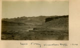
Kanab Canyon. View near mouth of tributary Little Springs Canyon. Coconino County, AZ. 1922
1922
Image
177
Kanab Creek, view looking toward mouth of Hack's Canyon. Stream intrenched in Supai, the top of which forms Esplanade. Strata are Supai, Hermit Coconino (forming slope), Kaibab sandstone and limestone, Kaibab cherty limestone. Coconino County, AZ. 1922
1922
Image
178
Kanab Valley, above the mouth of Jump Up Canyon. Section is Supai, erosional unconformity, Hermit Coconino, Kaibab sandstone, Kaibab limestone. Coconino County, AZ. 1922
1922
Image
179
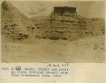
Knobs, Middle and Lower La Plata (Painted Desert) near Tuba Government Farm, 1914
1914
Image
180
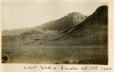
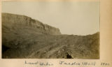
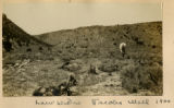
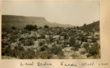
Land slides, Jacobs Well 1900
1900
Image
181
Land slides, Jacobs Well 1900
1900
Image
182
Land slides, Jacobs Well 1900
1900
Image
183
Land slides, Jacobs Well 1900
1900
Image
184
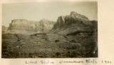
Land slides, Vermillion Cliffs, 1900 [1]
1900
Image
185
Land slides, Vermillion Cliffs, 1900 [2]
1900
Image
186
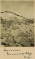
Landslide, Shinarump cliffs 1900
1900
Image
187
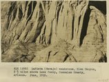
LaPlata (Navajo) sandstone, Glen Canyon, 3+ miles above Lees Ferry, Coconino County, Arizona. June, 1915.
1915
Image
188
LaPlata sandstone (Navajo sandstone) near Moenkopi Village, Coconino County, Arizona. June 1, 1915.
1915
Image
189
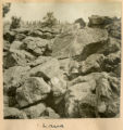
Lava
1900
Image
190
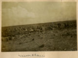
Lava flow
1900
Image
191
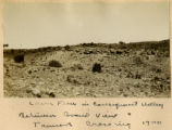
Lava flow in consequent valley between Grand View & Tanners Crossing 1900
1900
Image
192
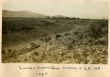
Lava, limestone valley & S.F. Mt., 1900
1900
Image
193
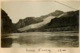
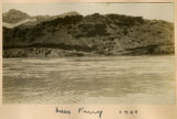
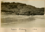
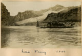
Lees Ferry, 1900 [1]
1900
Image
194
Lees Ferry, 1900 [2]
1900
Image
195
Lees Ferry, 1900 [3]
1900
Image
196
Lees Ferry, 1900 [4]
1900
Image
197
Lees Ferry, 1900 [5]
1900
Image
198
Lees Ferry, Vermillion Cliffs, 1900
1900
Image
199
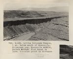
Little Colorado Canyon, 1 mi. below mouth of Moencopie, Shinarump cap, Moencopie middle, Kaibab bottom. Flat bench is lava. Coconino point in distance (Photo G431)
1913
Image
200
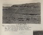
Little Colorado canyon, 1 mi. below mouth of Moencopie. Shinarump cap, Moencopie middle, Kaibab bottom. Flat bench is lava. Coconino point in distance (Photo G430)
1913
Image
176
-
200
of
400
<
3
4
5
6
7
8
9
10
11
12
>