|
|
Title | Collection Number And Name | Photo Number |
| 701 |
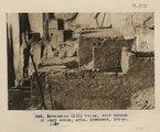 |
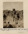
Betatakin cliff ruins, west branch of Sagy canon, Ariz., (Townsend photo, 1909) | P0013 Herbert E. Gregory Photograph Collection | P0013n04_38_0575 |
| 702 |
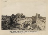 |
Mesa dwellings, Navojo Reservation (Townsend photo, 1909) | P0013 Herbert E. Gregory Photograph Collection | P0013n04_39_0576 |
| 703 |
 |
Cliff, LaPlata on Dolores at mouth of Sagy at Sosi canyon, Ariz., 1910 (Photo G166) | P0013 Herbert E. Gregory Photograph Collection | P0013n04_40_0577 |
| 704 |
 |
Cliff, LaPlata on Dolores at mouth of Sagy at Sosi canyon, AZ. 1910 (Photo G166) | P0013 Herbert E. Gregory Photograph Collection | P0013n04_40_0577 |
| 705 |
 |
Sagy at Soci canyon, Ariz. Walls of LaPlata sandstone. Skeleton Mesa in distance (S.M. Young photo, 1909) | P0013 Herbert E. Gregory Photograph Collection | P0013n04_41_0578 |
| 706 |
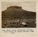 |
Butte (Moencopie strata), east branch of Copper Canyon, Utah, 1910 (Photo G167) | P0013 Herbert E. Gregory Photograph Collection | P0013n04_42_0579 |
| 707 |
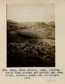 |
Noki Canyon, Utah, looking north down stream and across San Juan River, showing synclinal structure, 1910. | P0013 Herbert E. Gregory Photograph Collection | P0013n04_42_0580 |
| 708 |
 |
View, Noki canyon, La Plata over Dolores (Townsend photo 1909) | P0013 Herbert E. Gregory Photograph Collection | P0013n04_43_0581 |
| 709 |
 |
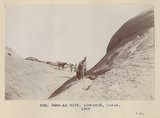
Trail up west wall, Noki Canyon, Utah (Townsend photo), 1910. | P0013 Herbert E. Gregory Photograph Collection | P0013n04_44_0582 |
| 710 |
 |
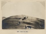
General view, Pahute [Noki] canyon, Utah, LaPlata on Dolores (Townsend photo), 1910. | P0013 Herbert E. Gregory Photograph Collection | P0013n04_45_0583 |
| 711 |
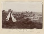 |
Camp, Pahute Mesa, Navajo Mtn in distance (Townsend photograph) | P0013 Herbert E. Gregory Photograph Collection | P0013n04_45verso_0584 |
| 712 |
 |
View in Pahute canyon, Utah (Townsend photo), 1909 | P0013 Herbert E. Gregory Photograph Collection | P0013n04_46_0585 |
| 713 |
 |
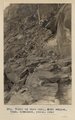
Earth Pillars. Pahute Canyon, Utah, 1910 (Photo G169) | P0013 Herbert E. Gregory Photograph Collection | P0013n04_47_0586 |
| 714 |
 |
View, Navajo Mt., Utah, from west run of Pahute Canyon, 1910 (Photo G170A) | P0013 Herbert E. Gregory Photograph Collection | P0013n04_47_0587 |
| 715 |
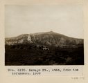 |
Navajo Mt., Utah, from the northeast, 1909 (G170) | P0013 Herbert E. Gregory Photograph Collection | P0013n04_48_0588 |
| 716 |
 |
View, northeast base, Navajo Mt. near Junction canyon, Utah. LaPlata, McElmo (?), Cretaceous (?) strata (Townsend photo), 1909 | P0013 Herbert E. Gregory Photograph Collection | P0013n04_49_0589 |
| 717 |
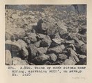 |
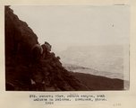
Talus or rock stream near spring, elevation 9000 ft., on Navajo Mt., 1910 (Photo N-M95) | P0013 Herbert E. Gregory Photograph Collection | P0013n04_50_0590 |
| 718 |
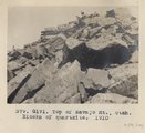 |
Top of Navajo Mt., Utah. Blocks of quartzite, 1910 (Photo G171) | P0013 Herbert E. Gregory Photograph Collection | P0013n04_50_0591 |
| 719 |
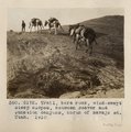 |
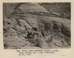
Trail, bare rock, wind-swept steep slopes, between Beaver and Junction canyons, north of Navajo Mt., Utah, 1910 (Photo G172) | P0013 Herbert E. Gregory Photograph Collection | P0013n04_50_0592 |
| 720 |
 |
Same as G172 (Trail from Navajo Mountain to Rainbow Bridge, Utah, in 1910, photo N-M96) | P0013 Herbert E. Gregory Photograph Collection | P0013n04_51_0593 |
| 721 |
 |
Same as G172 (Trail from Navajo Mountain to Rainbow Bridge, Utah, in 1910; photo G193) | P0013 Herbert E. Gregory Photograph Collection | P0013n04_51_0594 |
| 722 |
 |
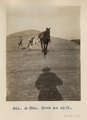
Same as G172 (Trail from Navajo Mountain to Rainbow Bridge, Utah; Townsend photo, 1909) | P0013 Herbert E. Gregory Photograph Collection | P0013n04_52_0595 |
| 723 |
 |
Same as 383 (Trail from Navajo Mountain to Rainbow Bridge, Utah; Townsend photo, 1909). | P0013 Herbert E. Gregory Photograph Collection | P0013n04_53_0598 |
| 724 |
 |
Trail near Junction canyon, north base, Navajo Mt., Utah (Townsend photo, 1909) | P0013 Herbert E. Gregory Photograph Collection | P0013n04_54_0596 |
| 725 |
 |
Owl Bridge, Nasja Canyon, Utah; north base of Navajo Mt., 1910 (Photo G174) | P0013 Herbert E. Gregory Photograph Collection | P0013n04_55_0597 |