Home
Browse
Ask Us
Chat
Harmful Language Statement
Log in
Photo Archives
Advanced Search
About
Over 70,000 photos covering a variety of topics from Marriott Library Special Collections
Year
1913
1914
1915
1916
1917
1918
1919
1920
1921
1922
1923
1924
1925
1926
1927
1928
1929
1930
1931
1932
1933
1934
1935
1936
1937
1938
1939
1940
1941
1942
1943
1944
TO
1913
1914
1915
1916
1917
1918
1919
1920
1921
1922
1923
1924
1925
1926
1927
1928
1929
1930
1931
1932
1933
1934
1935
1936
1937
1938
1939
1940
1941
1942
1943
1944
Type
Image
71
Format
image/jpeg
70
application/pdf
1
Collection Name
Herbert E. Gregory
71
Filters:
Collection Name:
"Herbert E. Gregory"
Collection:
uum_map
51
-
75
of
71
<
1
2
3
>
Gallery view
Number of results to display per page
10
25
50
100
200
Sort by Relevance
Sort by Title A-Z
Sort by Title Z-A
Sort by Date Ascending
Sort by Date Descending
Sort by Last Modified Ascending
Sort by Last Modified Descending
Sort by Photo Number
Title
Collection Number And Name
Photo Number
51
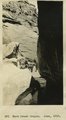
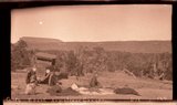
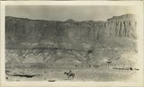
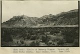
Warm Creek Canyon, June, 1915.
P0013 Herbert E. Gregory Photograph Collection
P0013n08_017_1340
52
West entrance to Hole-in-the-Rock, an eroded fault crack in Navajo sandstone on the west rim of Glen Canyon. A feature of the abandoned Escalante-Bluff Road. Garfield County, UT, 1944
P0013 Herbert E. Gregory Photograph Collection
P0013n12_054_2905
53
West entrance to Hole-in-the-Rock, an eroded fault crack in Navajo sandstone on the west rim of Glen Canyon. A feature of the abandoned Escalante-Bluff Road. Garfield County, UT, 1944
P0013 Herbert E. Gregory Photograph Collection
P0013n12_054_2904
54
West wall of Glen Canyon looking west across river from point 2 miles northwest of Castle Butte. Moenkopi (upper and middle) Shinarump Chinle, Wingate, Todilto, Kane County, UT, 1927
P0013 Herbert E. Gregory Photograph Collection
P0013n09_092_1898
55
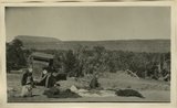
Camp scene, south bank of Armstrong Canyon looking northeast. Camp on Coconino; plateau in middle distance. Moenkopi capped by Shinarump; mesa in left background. Chinle and Glen Canyon, Fred Lowrey. San Juan County, UT, 1928
P0013 Herbert E. Gregory Photograph Collection
P0013n09_124_1961
56
Kane Springs Valley, east end of Gunsight Pass. Strata 'Sentinel' formation. Kane County, UT. 1922
P0013 Herbert E. Gregory Photograph Collection
P0013n08_126_1554
57
Kane Springs Valley, east end of Gunsight Pass. Strata 'Sentinel' formation. Kane County, UT. 1922
P0013 Herbert E. Gregory Photograph Collection
P0013n08_127_1555
58
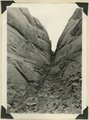
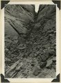
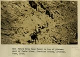
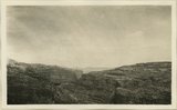
Trail from Lees Ferry to top of plateau east of Paria River, Coconino County, Arizona. June, 1915.
P0013 Herbert E. Gregory Photograph Collection
P0013n08_013_1331
59
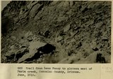
Trail from Lees Ferry to top of plateau east of Paria River, Coconino County, Arizona. June, 1915.
P0013 Herbert E. Gregory Photograph Collection
P0013n08_013_1332
60
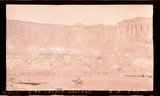
View looking N.40 degrees W. up Paria River, Arizona, from top of Shinarump, south side of Colorado at Lees Ferry, Coconino County, Arizona. June 5, 1915.
P0013 Herbert E. Gregory Photograph Collection
P0013n08_004_1313
61
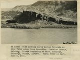
View looking north across Colorado at Lees Ferry along Echo Monocline, Coconino County, Arizona. Strata beginning at base: Moenkopi, Shinarump, Chinle, LaPlata. Paria River at left, June 6, 1915.
P0013 Herbert E. Gregory Photograph Collection
P0013n08_005_1314
62
West wall of Glen Canyon looking west across river from point 2 miles northwest of Castle Butte. Moenkopi (upper and middle) Shinarump Chinle, Wingate, Todilto, Kane County, UT, 1927
P0013 Herbert E. Gregory Photograph Collection
P0013n09_092_1898
63
Camp scene, south bank of Armstrong Canyon looking northeast. Camp on Coconino; plateau in middle distance. Moenkopi capped by Shinarump; mesa in left background. Chinle and Glen Canyon, Fred Lowrey. San Juan County, UT, 1928
P0013 Herbert E. Gregory Photograph Collection
P0013n09_124_1961
64
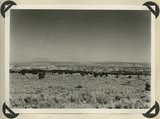
Looking down Beef Basin from point near mouth of Fable Valley. Coconino over Supai. Distant mesa wall of Colorado River, mouth of Fremont River. Chinle and Glen Canyon. San Juan County, UT, 1928
P0013 Herbert E. Gregory Photograph Collection
P0013n09_133_1978
65
Looking east across Paria River Canyon where it separates West and East Clark Benches. Upper Jurassic (foreground) and Navajo (background) dip northeast. Navajo Mountain and Kaiparowits Plateau are on opposite sides of Glen Canyon. Kane County, UT. 1944
P0013 Herbert E. Gregory Photograph Collection
P0013n12_037_2884
66
Kaibab Indian School near Moccasin looking northeast toward head of Two Mile Wash. Deep alluvial fill. Moenkopi capped by Shinarump (upper right), Chinle and Glen Canyon beds cliffs at upper left and middle distance (Lambs Point). Branch of Sevier fault crosses divide between Two Mile Wash and Sand Creek at base of Indian Point (left middle), Mohave County, AZ. 1939
P0013 Herbert E. Gregory Photograph Collection
P0013n11_089_2670
67
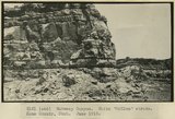
Wahweap Canyon. White 'McElmo' strata. Kane County, UT. June 1918
P0013 Herbert E. Gregory Photograph Collection
P0013n08_110_1521
68
Wahweap Canyon. White 'McElmo' strata. Kane County, UT. June 1918
P0013 Herbert E. Gregory Photograph Collection
P0013n08_109_1520
69
Middle of Wahweap Canyon. Mancos and Mesa Verde strata. Kane County, UT. June 1918
P0013 Herbert E. Gregory Photograph Collection
P0013n08_110_1522
70
Wahweap Canyon. White 'McElmo' strata. Kane County, UT. June 1918
P0013 Herbert E. Gregory Photograph Collection
P0013n08_109_1519
71
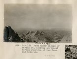
From upper slopes of Navaho Mt. looking northwest across Junction of San Juan and Colorado (Photo N-M158)
P0013 Herbert E. Gregory Photograph Collection
P0013n06_040_0903
51
-
75
of
71
<
1
2
3
>