|
|
Title | Collection Number And Name | Photo Number |
| 376 |
 |
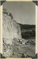
Wall of Kanab Canon near mouth 1900 | P0013 Herbert E. Gregory Photograph Collection | P0013n01_60_173 |
| 377 |
 |
Wall of White Rock Gulch. (tributary to Wahweap) 'Sentinel' strata. Kane County, UT. 1922 | P0013 Herbert E. Gregory Photograph Collection | P0013n08_132_1567 |
| 378 |
 |
Walls of alluvium along Red Creek. Garfield County, UT, 1940 | P0013 Herbert E. Gregory Photograph Collection | P0013n11_127_2718 |
| 379 |
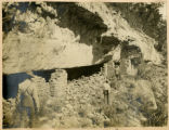 |
Walnut Canyon cliff dwellings | P0013 Herbert E. Gregory Photograph Collection | P0013n01_19_043 |
| 380 |
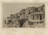 |
Walpi | P0013 Herbert E. Gregory Photograph Collection | P0013n03_60verso_0475 |
| 381 |
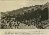 |
Water Pocket Fold, head of Burr Trail. Wingate sandstone. Garfield County, UT. June 1918 | P0013 Herbert E. Gregory Photograph Collection | P0013n08_068_1433 |
| 382 |
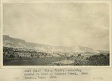 |
White Cliffs bordering canyon on east of Johnson Creek, Kane County, UT. 1922 | P0013 Herbert E. Gregory Photograph Collection | P0013n08_139_1582 |
| 383 |
 |
White Cliffs east of Johnson Creek. Kane County, UT. 1922 | P0013 Herbert E. Gregory Photograph Collection | P0013n08_140_1583 |
| 384 |
 |
Winsor formation type locality, Winsor Cove, Kane County, UT, 1939 | P0013 Herbert E. Gregory Photograph Collection | P0013n11_052_2610 |
| 385 |
 |
Winsor formation type locality, Winsor Cove, Kane County, UT, 1939 | P0013 Herbert E. Gregory Photograph Collection | P0013n11_052_2611 |
| 386 |
 |
Herbert E. Gregory Book 1: Colorado Plateau and Grand Canyon 1900, Navajo-Hopi 1909 | P0013 Herbert E. Gregory Photograph Collection | P0013n01 |
| 387 |
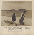 |
Little Colorado River, Luepp, May 1909. Mendenhall, Gregory, and Navajo. H. F. Robinson, photo. | P0013 Herbert E. Gregory Photograph Collection | P0013n03_74_0500 |
| 388 |
 |
Manuelito Springs east of Tohatchie, N.M. Shaler, photo | P0013 Herbert E. Gregory Photograph Collection | P0013n05_85_0813 |
| 389 |
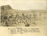 |
General view of Moencopie shales and sandstone (Permian?). Canyon Bonito, near Fort Defiance, Arizona, 1909 | P0013 Herbert E. Gregory Photograph Collection | P0013n02_005_205 |
| 390 |
 |
Same as G-85 (Many Waters Lake, Arizona, photo G-86) | P0013 Herbert E. Gregory Photograph Collection | P0013n02_047_293 |
| 391 |
 |
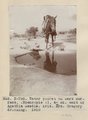
General view; erosion, talus, and slide cover. Tertiary. East side of Coiskai Mt. H.E.G. fixing drinking hole. (Photo N-M109) | P0013 Herbert E. Gregory Photograph Collection | P0013n05_09_0683 |
| 392 |
 |
Same as G172 (Trail from Navajo Mountain to Rainbow Bridge, Utah, in 1910, photo N-M96) | P0013 Herbert E. Gregory Photograph Collection | P0013n04_51_0593 |
| 393 |
 |
Same as G172 (Trail from Navajo Mountain to Rainbow Bridge, Utah, in 1910; photo G193) | P0013 Herbert E. Gregory Photograph Collection | P0013n04_51_0594 |
| 394 |
 |
Titicaca Island. 'Sacrificial Table.' (Near Chala). Showing Prof. Gregory. | P0013 Herbert E. Gregory Photograph Collection | P0013n13_046_9-3035 |
| 395 |
 |
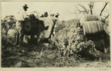
Camp scene. Elk Ridge near head Butte Canyon branch of arch Canyon. A.A. Baker and Edna Hope Gregory. San Juan County, UT, 1925 | P0013 Herbert E. Gregory Photograph Collection | P0013n09_061_1835 |
| 396 |
 |
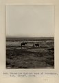
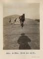
Water pocket on bare surface (Moencopie?), 4+ mi. east of Agathla Needle, Ariz. Mrs. Gregory drinking, 1910 (Photo N-M92) | P0013 Herbert E. Gregory Photograph Collection | P0013n04_34_0563a |
| 397 |
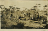 |
Camp Steves, dune area, South Australian desert [1] | P0013 Herbert E. Gregory Photograph Collection | P0013n13_107_9-3185 |
| 398 |
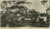 |
Camp Steves, dune area, South Australian desert [2] | P0013 Herbert E. Gregory Photograph Collection | P0013n13_107_9-3186 |
| 399 |
 |
Camp Steves, dune area, South Australian desert [3] | P0013 Herbert E. Gregory Photograph Collection | P0013n13_107_9-3187 |
| 400 |
 |
Near town of Paria. Chinle 'marls'. Kane County, UT. June 1918 | P0013 Herbert E. Gregory Photograph Collection | P0013n08_112_1525 |