Home
Browse
Ask Us
Chat
Harmful Language Statement
Log in
Photo Archives
Advanced Search
About
Over 70,000 photos covering a variety of topics from Marriott Library Special Collections
Year
1922
1923
1924
1925
1926
1927
1928
1929
1930
1931
1932
1933
1934
1935
1936
1937
1938
1939
TO
1922
1923
1924
1925
1926
1927
1928
1929
1930
1931
1932
1933
1934
1935
1936
1937
1938
1939
Type
Image
15
Format
image/jpeg
15
Collection Name
Herbert E. Gregory
15
Filters:
Collection Name:
"Herbert E. Gregory"
Collection:
"uum_map"
1
-
25
of
15
Gallery view
Number of results to display per page
10
25
50
100
200
Sort by Relevance
Sort by Title A-Z
Sort by Title Z-A
Sort by Date Ascending
Sort by Date Descending
Sort by Last Modified Ascending
Sort by Last Modified Descending
Sort by Photo Number
Title
Collection Number And Name
Photo Number
1
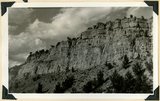
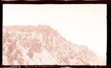
Straight Cliffs sandstone overlying Tropic shale. Back of School House, Orderville, Kane County, UT, 1938
P0013 Herbert E. Gregory Photograph Collection
P0013n11_047_2602
2
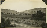
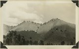
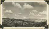
Same as 191 (Looking north across Orderville, Sevier fault), taken nearer Orderville.
P0013 Herbert E. Gregory Photograph Collection
P0013n10_218_2481
3
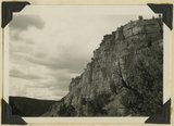
Straight Cliffs formation (Cretaceous). Orderville, Kane County, Utah. 1936
P0013 Herbert E. Gregory Photograph Collection
P0013n10_197_2440
4
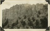
Straight Cliffs, sandstone Cretaceous above Tropic shale. Orderville, Kane County, Utah, 1932.
P0013 Herbert E. Gregory Photograph Collection
P0013n10_118_2288
5
Straight Cliffs, sandstone north of Orderville, Kane County, Utah, 1932.
P0013 Herbert E. Gregory Photograph Collection
P0013n10_119_2289
6
Tropic shale Muddy Brook Valley west of Orderville, Kane County, Utah, 1932.
P0013 Herbert E. Gregory Photograph Collection
P0013n10_119_2290
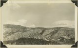
7
Base of Straight Cliffs formation (Cretaceous) at Orderville. Tropic shale forms slope at bottom. Kane County, UT, 1939
P0013 Herbert E. Gregory Photograph Collection
P0013n11_045_2598
8
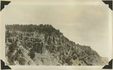
Elkheart Cliffs, blood-red buttes at base, on east side of the Sevier fault near Orderville,Kane County, Utah, 1937.
P0013 Herbert E. Gregory Photograph Collection
P0013n10_196_2436
9
Straight Cliffs, sandstone north of Orderville, Kane County, Utah, 1932.
P0013 Herbert E. Gregory Photograph Collection
P0013n10_119_2289
10
Tilted block broken from Sevier fault, Navajo capped by Carmel. Orderville, Kane County, Utah, 1937.
P0013 Herbert E. Gregory Photograph Collection
P0013n10_198_2442
11
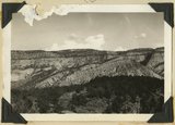
Alluvial terraces, Parunuweap Valley between Orderville and Mt. Carmel. Lie unevenly on Tropic shale. Kane County, UT. 1937
P0013 Herbert E. Gregory Photograph Collection
P0013n11_022_2557
12
Looking north along Sevier fault at Orderville. Right, Carmel and Navajo; left, Straight Cliffs formation (Crfetaceous). Kane County, Utah, 1936.
P0013 Herbert E. Gregory Photograph Collection
P0013n10_139_2326
13
View looking east across "The Cove," near Orderville: foreground, topmost Jurassic and Tropic formation; distance, Elkheart Cliffs, Navajo capped by Carmel. Kane County, Utah, 1938.
P0013 Herbert E. Gregory Photograph Collection
P0013n10_226_2495
14
Elkheart Cliffs along highway about mile north of Orderville. Background and right foreground Navajo sandstone capped by Carmel formation. Left foreground slice of cliff dropped down along Sevier fault. Kane County, Utah, 1932.
P0013 Herbert E. Gregory Photograph Collection
P0013n10_120_2291
15
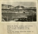
Looking east across valley of the Parunuweap from a point between Orderville and Mt. Carmel. Cliffs are Navajo sandstone capped by 'Marine Jurassic'
P0013 Herbert E. Gregory Photograph Collection
P0013n08_162_1643
1
-
25
of
15