|
|
Title | Collection Number And Name | Photo Number |
| 1 |
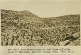 |
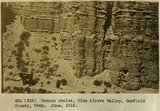
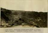
Mesa Verde strata at Coal Mines 4+ miles south of Escalante, Garfield County, Utah, June, 1915. | P0013 Herbert E. Gregory Photograph Collection | P0013n08_023_1354 |
| 2 |
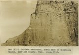 |
LaPlata sandstone, north bank of Escalante Canyon, Garfield County, Utah, June, 1915. | P0013 Herbert E. Gregory Photograph Collection | P0013n08_024_1355 |
| 3 |
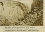 |
Partly detached arch, first stage in formation of natural bridge in LaPlata sandstone, Escalante Canyon, Garfield County, Utah, June, 1915. | P0013 Herbert E. Gregory Photograph Collection | P0013n08_024_1356 |
| 4 |
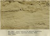 |
Cross bedding in LaPlata sandstone, Escalante Canyon, Garfield County, Utah, June, 1915. | P0013 Herbert E. Gregory Photograph Collection | P0013n08_025_1357 |
| 5 |
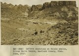 |
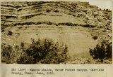
LaPlata sandstone on Chinle shales, Silver Falls Canyon, Garfield County, Utah, June, 1915. | P0013 Herbert E. Gregory Photograph Collection | P0013n08_025_1358 |
| 6 |
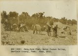 |
Camp, Burr Flat, Water Pocket Valley, Garfield County, Utah, June, 1915. | P0013 Herbert E. Gregory Photograph Collection | P0013n08_026_1359 |
| 7 |
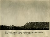 |
Water Pocket Monocline, Garfield County, Utah, looking N. 15 degrees W., June, 1915. | P0013 Herbert E. Gregory Photograph Collection | P0013n08_026_1360 |
| 8 |
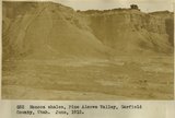 |
Mancos shales, Pine Alcove Valley, Garfield County, Utah, June, 1915. | P0013 Herbert E. Gregory Photograph Collection | P0013n08_027_1361 |
| 9 |
 |
Mancos shales, Pine Alcove Valley, Garfield County, Utah, June, 1915. | P0013 Herbert E. Gregory Photograph Collection | P0013n08_027_1362 |
| 10 |
 |
Mancos shales, Pine Alcove Valley, Garfield County, Utah, June, 1915. | P0013 Herbert E. Gregory Photograph Collection | P0013n08_028_1363 |
| 11 |
 |
Mancos shales, Water Pocket Canyon, Garfield County, Utah, June, 1915. | P0013 Herbert E. Gregory Photograph Collection | P0013n08_028_1364 |
| 12 |
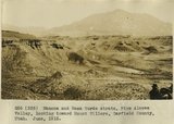 |
Mancos and Mesa Verde strata, Pine Alcove Valley, looking toward Mount Hillers, Garfield County, Utah, June, 1915. | P0013 Herbert E. Gregory Photograph Collection | P0013n08_029_1365 |
| 13 |
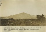 |
Mount Holmes looking southeast from base of Mount Hillers at Star Ranch, Garfield County, Utah, June, 1915. | P0013 Herbert E. Gregory Photograph Collection | P0013n08_029_1366 |
| 14 |
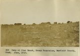 |
Camp at Star Ranch, Henry Mountains, Garfield County, Utah, June, 1915. | P0013 Herbert E. Gregory Photograph Collection | P0013n08_030_1367 |
| 15 |
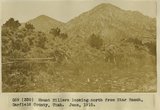 |
Mount Hillers looking north from Star Ranch, Garfield County, Utah, June, 1915. | P0013 Herbert E. Gregory Photograph Collection | P0013n08_030_1368 |
| 16 |
 |
View looking east from near divide at head of Water Pocket Canyon. Cretaceous strata, hogback. Garfield County, UT. June 1918 | P0013 Herbert E. Gregory Photograph Collection | P0013n08_067_1431 |
| 17 |
 |
Head of Water Pocket Valley. Sharp turn in axis of fold in Cretaceous sandstone. Garfield County, UT. June 1918 | P0013 Herbert E. Gregory Photograph Collection | P0013n08_067_1432 |
| 18 |
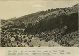 |
Water Pocket Fold, head of Burr Trail. Wingate sandstone. Garfield County, UT. June 1918 | P0013 Herbert E. Gregory Photograph Collection | P0013n08_068_1433 |
| 19 |
 |
Water Pocket Fold near foot of Burr Trail. General view Cretaceous strata. Garfield County, UT. June 1918 | P0013 Herbert E. Gregory Photograph Collection | P0013n08_068_1434 |
| 20 |
 |
East of the foot of Burr Trail, Water Pocket Fold. Cretaceous strata. Garfield County, UT. June 1918 | P0013 Herbert E. Gregory Photograph Collection | P0013n08_069_1435 |
| 21 |
 |
Scene in Silver Falls Canyon.Garfield County, UT. June 1918 | P0013 Herbert E. Gregory Photograph Collection | P0013n08_082_1461 |
| 22 |
 |
Upper Silver Falls Canyon. Chinle strata below Wingate. Garfield County, UT. June 1918 | P0013 Herbert E. Gregory Photograph Collection | P0013n08_082_1462 |
| 23 |
 |
Upper Silver Falls Canyon. Chinle beds below Wingate. Garfield County, UT. June 1918 | P0013 Herbert E. Gregory Photograph Collection | P0013n08_083_1463 |
| 24 |
 |
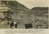
Silver Falls Canyon. Middle LaPlata and Navajo sandstone. Garfield County, UT. June 1918 | P0013 Herbert E. Gregory Photograph Collection | P0013n08_083_1464 |
| 25 |
 |
Escalante Canyon near mouth of Silver Falls Canyon. Garfield County, UT. June 1918 | P0013 Herbert E. Gregory Photograph Collection | P0013n08_084_1465 |