|
|
Title | Collection Number And Name | Photo Number |
| 376 |
 |
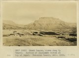
Kanab Canyon, above mouth of Jump Up Canyon. Surface and water pocket of 'Esplanade' developed at top of Supai. Coconino County, AZ. 1922 | P0013 Herbert E. Gregory Photograph Collection | P0013n08_143_1591 |
| 377 |
 |
Kanab Canyon, above Jump Up Canyon. Surface of Esplanade formed at top of Supai. Coconino County, AZ. 1922 | P0013 Herbert E. Gregory Photograph Collection | P0013n08_144_1592 |
| 378 |
 |
Kanab Valley, above the mouth of Jump Up Canyon. Section is Supai, erosional unconformity, Hermit Coconino, Kaibab sandstone, Kaibab limestone. Coconino County, AZ. 1922 | P0013 Herbert E. Gregory Photograph Collection | P0013n08_144_1593 |
| 379 |
 |
Kanab Creek, view looking toward mouth of Hack's Canyon. Stream intrenched in Supai, the top of which forms Esplanade. Strata are Supai, Hermit Coconino (forming slope), Kaibab sandstone and limestone, Kaibab cherty limestone. Coconino County, AZ. 1922 | P0013 Herbert E. Gregory Photograph Collection | P0013n08_145_1594 |
| 380 |
 |
Kanab Canyon, 2 miles south, tributary Little Springs Canyon. Section includes Hermit Coconino, Kaibab, Coconino County, AZ. 1922 | P0013 Herbert E. Gregory Photograph Collection | P0013n08_145_1595 |
| 381 |
 |
Kanab Canyon. View near mouth of tributary Little Springs Canyon. Coconino County, AZ. 1922 | P0013 Herbert E. Gregory Photograph Collection | P0013n08_146_1597 |
| 382 |
 |
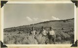
Camp at Reservoir 2 miles south of Fredonia. Dr. and Mrs. Noble and three packers. Coconino County, AZ. 1922 | P0013 Herbert E. Gregory Photograph Collection | P0013n08_147_1600 |
| 383 |
 |
Looking up canyon of lower Kanab Creek from a point 3 miles below the mouth of Snake Gulch. AZ. 1922 | P0013 Herbert E. Gregory Photograph Collection | P0013n08_161_1637 |
| 384 |
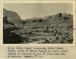 |
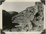
Supai Sandstone, lower Kanab Creek. Mouth of Karks Canyon at left. Arrow points to horizon of bed of limestone conglomerate. AZ | P0013 Herbert E. Gregory Photograph Collection | P0013n08_161_1638 |
| 385 |
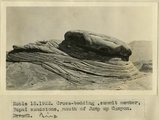 |
Cross-bedding, summit member, Supai sandstone, mouth of Jump Up Canyon, AZ. 1922 | P0013 Herbert E. Gregory Photograph Collection | P0013n08_161_1639 |
| 386 |
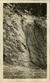 |
[Faulting in rock layers, probably Kanab Creek Canyon, Arizona, 1922] | P0013 Herbert E. Gregory Photograph Collection | P0013n08_161_1640 |
| 387 |
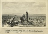 |
First camp out of Fredonia, UT. 1922 | P0013 Herbert E. Gregory Photograph Collection | P0013n08_163_1632 |
| 388 |
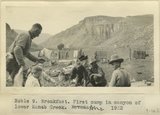 |
Breakfast. First camp in canyon of lower Kanab Creek, AZ. 1922 | P0013 Herbert E. Gregory Photograph Collection | P0013n08_164_1633 |
| 389 |
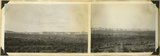
 |
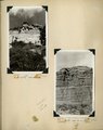
Panoramic with view attached | P0013 Herbert E. Gregory Photograph Collection | P0013n08_170_1666 |
| 390 |
 |
Block mesas from the south, panorama. | P0013 Herbert E. Gregory Photograph Collection | P0013n10_174_2391 |
| 391 |
 |
Block mesas from south, panorama. | P0013 Herbert E. Gregory Photograph Collection | P0013n10_174_2391A |
| 392 |
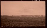
 |
Plateau south of Block Mesas | P0013 Herbert E. Gregory Photograph Collection | P0013n10_176_2395 |
| 393 |
 |
Plateau south of Block mesas. Grantham, Stringham, and guide (right), 1937. | P0013 Herbert E. Gregory Photograph Collection | P0013n10_176_2395 |
| 394 |
 |
Herbert E. Gregory Book 11: Colorado Plateau, 1938-1942 | P0013 Herbert E. Gregory Photograph Collection | P0013n11 |
| 395 |
 |
The Steamboat. Shnabkaib (bottom) and upper red level of Moenkopi capped in part by Shinarump 2 miles west of Fredonia, Coconino County, AZ. 1939 | P0013 Herbert E. Gregory Photograph Collection | P0013n11_061_2628 |
| 396 |
 |
The Steamboat. Shnabkaib (bottom) and upper red level of Moenkopi capped in part by Shinarump 2 miles west of Fredonia, Coconino County, AZ. 1939 | P0013 Herbert E. Gregory Photograph Collection | P0013n11_062_2629 |
| 397 |
 |
Northern edge Kanab Plateau. Village of Fredonia on surface eroded from lower Moenkopi beds and crossed by Kanab Creek. Buttes of Moenkopi capped by Shinarump (right), Coconino County, August, 1939 | P0013 Herbert E. Gregory Photograph Collection | P0013n11_067_2637 |
| 398 |
 |
Shinarump and Moenkopi beds disturbed by a local fault 3 miles north of Fredonia, Coconino County, AZ. 1939 | P0013 Herbert E. Gregory Photograph Collection | P0013n11_069_2641 |
| 399 |
 |
Cowboy Butte 2 miles north of Fredonia. Moenkopi (Shnabkaib member at base) and Shinarump, Coconino County, AZ. 1939 | P0013 Herbert E. Gregory Photograph Collection | P0013n11_103_2694 |
| 400 |
 |
Timpoweap member of the Moenkopi formation. Kaibab at base, upstream. East rim of the Kaibab Plateau near the UT-AZ line. Coconino County, AZ, 1944 | P0013 Herbert E. Gregory Photograph Collection | P0013n12_049_2901 |