|
|
Title | Collection Number And Name | Photo Number |
| 351 |
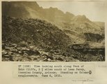 |
View looking south along face of Echo Cliffs, 2+ miles south of Lees Ferry, Coconino County, Arizona. Standing on Shinarump conglomerate. June 6, 1915. | P0013 Herbert E. Gregory Photograph Collection | P0013n08_006_1316 |
| 352 |
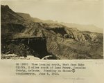 |
View looking south along face of Echo Cliffs, 2 miles south of Lees Ferry, Coconino County, Arizona. Standing on Shinarump conglomerate. June 6, 1915. | P0013 Herbert E. Gregory Photograph Collection | P0013n08_006_1317 |
| 353 |
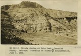 |
Chinle shales at Echo Peak, Coconino County, Arizona. Standing on Shinarump conglomerate. June 6, 1915. | P0013 Herbert E. Gregory Photograph Collection | P0013n08_007_1318 |
| 354 |
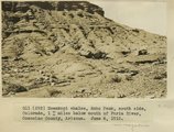 |
Moenkopi shales, Echo Peak, south side, Colorado, 1+ miles below mouth of Paria River, Coconino County, Arizona. June 6, 1915. | P0013 Herbert E. Gregory Photograph Collection | P0013n08_008_1320 |
| 355 |
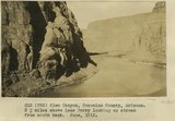 |
Glen Canyon, Coconino County, Arizona, 3+ miles above Lees Ferry looking up stream from south bank. June 1915. | P0013 Herbert E. Gregory Photograph Collection | P0013n08_008_1321 |
| 356 |
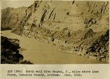 |
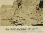
North wall Glen Canyon 2 miles above Lees Ferry, Coconino County, Arizona. June, 1915. | P0013 Herbert E. Gregory Photograph Collection | P0013n08_009_1322 |
| 357 |
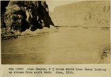 |
Glen Canyon, 3+ miles above Lees Ferry looking up stream from south bank. June, 1915. | P0013 Herbert E. Gregory Photograph Collection | P0013n08_009_1323 |
| 358 |
 |
Glen Canyon, 3+ miles above Lees Ferry Coconino County, Arizona. June, 1915. | P0013 Herbert E. Gregory Photograph Collection | P0013n08_010_1324 |
| 359 |
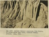 |
LaPlata (Navajo) sandstone, Glen Canyon, 3+ miles above Lees Ferry, Coconino County, Arizona. June, 1915. | P0013 Herbert E. Gregory Photograph Collection | P0013n08_010_1325 |
| 360 |
 |
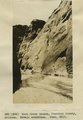
Permian (Moenkopi) cliff, South side, Colorado at Lees Ferry, Lees Ferry, Coconino County, Arizona. June, 1915. | P0013 Herbert E. Gregory Photograph Collection | P0013n08_011_1326 |
| 361 |
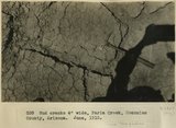 |
Mud cracks 4" wide, Paria Creek, Coconino County, Arizona. June, 1915. | P0013 Herbert E. Gregory Photograph Collection | P0013n08_012_1329 |
| 362 |
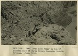 |
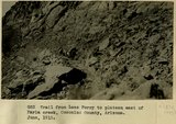
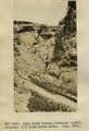
Trail from Lees Ferry to top of plateau east of Paria River, Coconino County, Arizona. June, 1915. | P0013 Herbert E. Gregory Photograph Collection | P0013n08_012_1330 |
| 363 |
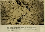 |
Trail from Lees Ferry to top of plateau east of Paria River, Coconino County, Arizona. June, 1915. | P0013 Herbert E. Gregory Photograph Collection | P0013n08_013_1331 |
| 364 |
 |
Trail from Lees Ferry to top of plateau east of Paria River, Coconino County, Arizona. June, 1915. | P0013 Herbert E. Gregory Photograph Collection | P0013n08_013_1332 |
| 365 |
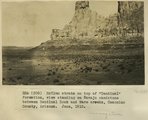 |
McElmo strata on top of "Sentinal" formation, view standing on Navajo sandstone between Sentinal Rock and Warm creeks, Coconino County, Arizona, June, 1915. | P0013 Herbert E. Gregory Photograph Collection | P0013n08_014_1333 |
| 366 |
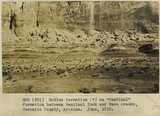 |
McElmo strata (?) on "Sentinal" formation, between Sentinal Rock and Warm creeks, Coconino County, Arizona, June, 1915. | P0013 Herbert E. Gregory Photograph Collection | P0013n08_014_1334 |
| 367 |
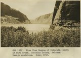 |
View Glen Canyon of Colorado, mouth of Warm Creek, Coconino County, Arizona. Navajo sandstone. June, 1915. | P0013 Herbert E. Gregory Photograph Collection | P0013n08_015_1335 |
| 368 |
 |
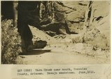
Warm Creek Canyon, Coconino County, Arizona..Walls of Navajo sandstone, June, 1915. | P0013 Herbert E. Gregory Photograph Collection | P0013n08_015_1336 |
| 369 |
 |
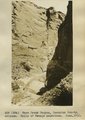
Warm Creek near mouth, Coconino County, Arizona. Navajo sandstone, June, 1915. | P0013 Herbert E. Gregory Photograph Collection | P0013n08_015_1337 |
| 370 |
 |
Warm Creek Canyon, Coconino County, Arizona, 1+ miles above mouth. June, 1915. | P0013 Herbert E. Gregory Photograph Collection | P0013n08_016_1338 |
| 371 |
 |
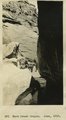
Warm Creek Canyon, Coconino County, Arizona.. Navajo sandstone, June, 1915. | P0013 Herbert E. Gregory Photograph Collection | P0013n08_016_1339 |
| 372 |
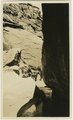 |
Warm Creek Canyon, June, 1915. | P0013 Herbert E. Gregory Photograph Collection | P0013n08_017_1340 |
| 373 |
 |
Warm Creek Canyon, June, 1915. | P0013 Herbert E. Gregory Photograph Collection | P0013n08_017_1340 |
| 374 |
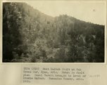 |
West Kaibab fault at Oak Creek Mar, Ryan, AZ. Notch is fault plan. Basal Hermit brought to level of Middle Kaibab. Coconino County, AZ. 1922 | P0013 Herbert E. Gregory Photograph Collection | P0013n08_143_1589 |
| 375 |
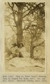 |
Camp on 'Lost Trail' between Jump Up Canyon and Ryan, AZ. Dr. and Mrs. Noble. Coconino County, AZ. 1922 | P0013 Herbert E. Gregory Photograph Collection | P0013n08_143_1590 |