|
|
Title | Collection Number And Name | Photo Number |
| 1 |
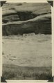 |
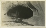
Scenes en route from Caroline to Augusta Bridge. 1925, Lee | P0013 Herbert E. Gregory Photograph Collection | P0013n09_177_2055 |
| 2 |
 |
Views in Arch Canyon near the ranger station east of Bears Ears, UT, cut about 1,000 feet in a white sandstone supposed to be Coconino sandstone. Panorama. Lee-1925 | P0013 Herbert E. Gregory Photograph Collection | P0013n09_185_2063 |
| 3 |
 |
Views of Armstrong Canyon and Henry Mountains from near Bears Ears, UT. Lee-1925 | P0013 Herbert E. Gregory Photograph Collection | P0013n09_186_2064 |
| 4 |
 |
Views of upper and middle La Plata sandstone northwest of Bluff, UT | P0013 Herbert E. Gregory Photograph Collection | P0013n09_192_2070 |
| 5 |
 |
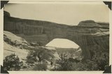
Early morning from Caroline Bridge, Bridges National Monument, UT | P0013 Herbert E. Gregory Photograph Collection | P0013n09_188_2066 |
| 6 |
 |
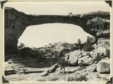
Edwin Bridge or Owachomo Bridge, in Bridges National Monument. The figure is Dan Perkins and his horse Cap | P0013 Herbert E. Gregory Photograph Collection | P0013n09_187_2065 |
| 7 |
 |
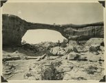
Edwin Bridge, or Owachomo Bridge, in Bridges National Monument. The figure is Dan Perkins and his horse | P0013 Herbert E. Gregory Photograph Collection | P0013n09_190_2068 |
| 8 |
 |
Edwin Bridge, or Owachomo Bridge, in Bridges National Monument. The figure is Dan Perkins and his horse | P0013 Herbert E. Gregory Photograph Collection | P0013n09_189_2067 |
| 9 |
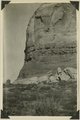 |
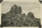
Detail of Church Rock in Dry Valley showing the red middle La Plata. W.W. Boyer is standing on the lower La Plata as described by Whitman Cross | P0013 Herbert E. Gregory Photograph Collection | P0013n09_180_2058 |
| 10 |
 |
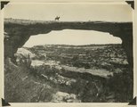
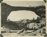
Augusta Bridge, Bridges National Monument, UT. 1925 | P0013 Herbert E. Gregory Photograph Collection | P0013n09_176_2054 |
| 11 |
 |
Bluff at Bluff, UT | P0013 Herbert E. Gregory Photograph Collection | P0013n09_191_2069 |
| 12 |
 |
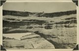
Bluff on the Moab road about 43 miles north of Monticello, Utah, showing LaPlata sandstone and McElmo formation. The upper La plata is about 200 feet thick and the lower La plata, the top of which is seen here, is about 300 feet, these sandstones are separated by red, shaly crinkled material. Lee, 1925. | P0013 Herbert E. Gregory Photograph Collection | P0013n09_179_2057 |
| 13 |
 |
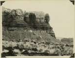
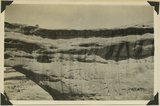
Church Rock in Dry Valley north of Monticello, UT, composed of La Plata sandstone. Near the base is red, shaly sandstone, middle La Plata, 42 feet thick, Lee, 1925 | P0013 Herbert E. Gregory Photograph Collection | P0013n09_181_2059 |
| 14 |
 |
Mexican Hat, UT, Lee, 1925 | P0013 Herbert E. Gregory Photograph Collection | P0013n09_182_2060 |
| 15 |
 |
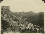
Monument of LaPlata sandstone resting on Chinle formation near the vanadium mine, northeast of Monticello, UT. Lee 1925 | P0013 Herbert E. Gregory Photograph Collection | P0013n09_178_2056 |
| 16 |
 |
The Navajo Twins, Bluff, UT | P0013 Herbert E. Gregory Photograph Collection | P0013n09_183_2061 |
| 17 |
 |
Panorama of Augusta Bridge, Bridges National Monument, UT. 1925 | P0013 Herbert E. Gregory Photograph Collection | P0013n09_174_2050 |
| 18 |
 |
Panorama of Augusta Bridge, Bridges National Monument, UT. 1925 | P0013 Herbert E. Gregory Photograph Collection | P0013n09_174_2051 |
| 19 |
 |
Panorama of Augusta Bridge, Bridges National Monument, UT. 1925 | P0013 Herbert E. Gregory Photograph Collection | P0013n09_175_2052 |
| 20 |
 |
Panorama of Augusta Bridge, Bridges National Monument, UT. 1925 | P0013 Herbert E. Gregory Photograph Collection | P0013n09_175_2053 |
| 21 |
 |
Wind-formed ripples on Colorado River near Moab, UT. 1925 | P0013 Herbert E. Gregory Photograph Collection | P0013n09_173_2049 |
| 22 |
 |
Wingate sandstone and Chinle formation on road to Bears Ears, UT, 1925 | P0013 Herbert E. Gregory Photograph Collection | P0013n09_184_2062 |
| 23 |
 |
Cliff house north side of San Juan near Bluff | P0013 Herbert E. Gregory Photograph Collection | P0013n09_155_2014 |
| 24 |
 |
Cliff House, Fable Valley (Fred Lowrey, Honolulu) | P0013 Herbert E. Gregory Photograph Collection | P0013n09_145_1997 |
| 25 |
 |
Cliff House, Fable Valley (Fred Lowrey, Honolulu) | P0013 Herbert E. Gregory Photograph Collection | P0013n09_145_1998 |