|
|
Title | Collection Number And Name | Photo Number |
| 1 |
 |
Herbert E. Gregory Book 13: Photographs taken on Yale Peruvian Expeditions, 1911-1915 | P0013 Herbert E. Gregory Photograph Collection | P0013n13 |
| 2 |
 |
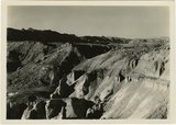
Bark Wash, Utah 1943 | P0013 Herbert E. Gregory Photograph Collection | P0013n16_11_04 |
| 3 |
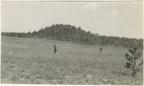 |
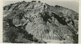
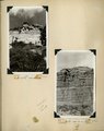
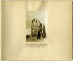
Bowers Knoll; Volcano viewed from northwest. Garfield County, UT. 1944 | P0013 Herbert E. Gregory Photograph Collection | P0013n12_076_2940B |
| 4 |
 |
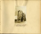
Brian Head formation, branch of Asay Creek; lies beneath basalt flows. Garfield County, UT, 1944 | P0013 Herbert E. Gregory Photograph Collection | P0013n12_072_2935 |
| 5 |
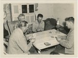 |
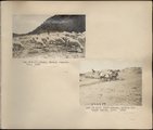
Card players, Paria Valley camp, 1943 | P0013 Herbert E. Gregory Photograph Collection | P0013n16_11_01 |
| 6 |
 |
Chinle formation, Petrified Forest member. Head of Fossil Wood Creek. Kane County, UT. 1943 | P0013 Herbert E. Gregory Photograph Collection | P0013n12_023_2873A |
| 7 |
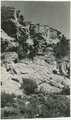 |
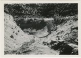
Contact of Kayenta formation (foreground) and Navajo sandstone Park Wash above the mouth of Five Pines Wash. Kane County, UT. 1943 | P0013 Herbert E. Gregory Photograph Collection | P0013n12_026_2877B |
| 8 |
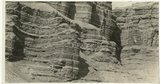 |
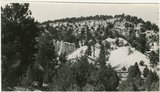
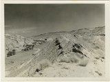
Cretaceous shales (tropic formation). Antimony Canyon, Garfield County, UT. 1943 | P0013 Herbert E. Gregory Photograph Collection | P0013n12_010_2854A |
| 9 |
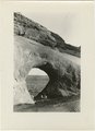 |
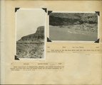
East side of Lone Rock on Wah Weap Creek | P0013 Herbert E. Gregory Photograph Collection | P0013n16_12_10 |
| 10 |
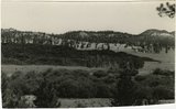 |
End of lava flow 6 miles long in Black Creek Valley | P0013 Herbert E. Gregory Photograph Collection | P0013n16_12_12 |
| 11 |
 |
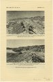
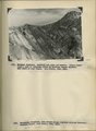
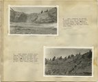
Eroded flank of the East Kaibab monocline at the junction of Paria River and Cottonwood Creek (left center). The sequence is Navajo (left), upper Jurassic (largely eroded), Dakota, Tropic, and Straight Cliffs. Kane County, UT, 1944 | P0013 Herbert E. Gregory Photograph Collection | P0013n12_040_2887 |
| 12 |
 |
Features of the East Kaibab monocline [and] Structural relations of rocks along Utah-Arizona boundary | P0013 Herbert E. Gregory Photograph Collection | P0013n16_12_17 |
| 13 |
 |
Flat lying Upper Jurassic (foreground) and Cretaceous strata bed abruptly upward against the Navajo on the flank of the East Kaibab monocline (left sky line). Table Cliffs (right sky line) is about 50 miles north. Paria Valley near Adairville. Kane County, UT. 1944 | P0013 Herbert E. Gregory Photograph Collection | P0013n12_039_2886 |
| 14 |
 |
Herbert E. Gregory Book 10: San Juan, Zion, Capitol Reef, 1915-1938 | P0013 Herbert E. Gregory Photograph Collection | P0013n10 |
| 15 |
 |
Herbert E. Gregory Book 11: Colorado Plateau, 1938-1942 | P0013 Herbert E. Gregory Photograph Collection | P0013n11 |
| 16 |
 |
Herbert E. Gregory Book 12: Colorado Plateau, Province, 1942-1944 | P0013 Herbert E. Gregory Photograph Collection | P0013n12 |
| 17 |
 |
Herbert E. Gregory Book 1: Colorado Plateau and Grand Canyon 1900, Navajo-Hopi 1909 | P0013 Herbert E. Gregory Photograph Collection | P0013n01 |
| 18 |
 |
Herbert E. Gregory Book 2: Navajo-Hopi, San Juan 1909 | P0013 Herbert E. Gregory Photograph Collection | P0013n02_unbound |
| 19 |
 |
Herbert E. Gregory Book 2: Navajo-Hopi, San Juan 1909 | P0013 Herbert E. Gregory Photograph Collection | P0013n02 |
| 20 |
 |
Herbert E. Gregory Book 3: Navajo-Hopi, Arizona-New Mexico, 1909 | P0013 Herbert E. Gregory Photograph Collection | P0013n03 |
| 21 |
 |
Herbert E. Gregory Book 4: Navajo, San Juan, 1910 | P0013 Herbert E. Gregory Photograph Collection | P0013n04 |
| 22 |
 |
Herbert E. Gregory Book 5: Navajo, 1911 | P0013 Herbert E. Gregory Photograph Collection | P0013n05 |
| 23 |
 |
Herbert E. Gregory Book 6: Navajo, 1913 | P0013 Herbert E. Gregory Photograph Collection | P0013n06 |
| 24 |
 |
Herbert E. Gregory Book 7: Navajo, 1913, 1914 | P0013 Herbert E. Gregory Photograph Collection | P0013n07 |
| 25 |
 |
Herbert E. Gregory Book 9: Utah, California, 1924-1928 | P0013 Herbert E. Gregory Photograph Collection | P0013n09 |