Over 70,000 photos covering a variety of topics from Marriott Library Special Collections
TO
| Title | Collection Number And Name | Photo Number | ||
|---|---|---|---|---|
| 1 |
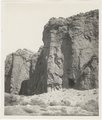 |
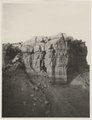
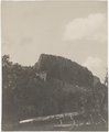
Ash, Twin Buttes (Photo G252) | P0013 Herbert E. Gregory Photograph Collection | P0013n05_54_0755 |
| 2 |
 |
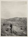
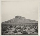
Butte, 3± mi. west of Stiles Ranche (Photo G238) | P0013 Herbert E. Gregory Photograph Collection | P0013n05_43_0739 |
| 3 |
 |
Dike (diabase), Stiles Ranche, 30± mi. north of Winslow, AZ. 1911 (Photo G236) | P0013 Herbert E. Gregory Photograph Collection | P0013n05_41_0737 |
| 4 |
 |
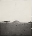
Dike (diabase?), Stiles Ranche, Moqui Buttes region, AZ. 1911 (Photo G235) | P0013 Herbert E. Gregory Photograph Collection | P0013n05_40_0736 |
| 5 |
 |
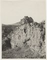
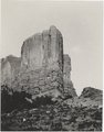
Eroded neck at northwest corner of Moqui Butte area (Photo G233) | P0013 Herbert E. Gregory Photograph Collection | P0013n05_38_0733 |
| 6 |
 |
Erosion column. Block of Dakota resting on LaPlata, Southeast of Gallup on west line of Wingate reservation. VII, 3. 1911 (Photo G189) | P0013 Herbert E. Gregory Photograph Collection | P0013n05_01_0662 |
| 7 |
 |
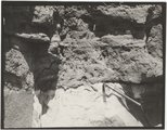
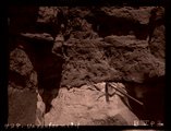
Erosion in Dolroes near Tuba. Heald, photo. 1911 (Photo G306) | P0013 Herbert E. Gregory Photograph Collection | P0013n05_91_0822 |
| 8 |
 |
Jetty-to Springs, Mesa Verde sandstone on Mancos shale. 1911 (Photo G224) | P0013 Herbert E. Gregory Photograph Collection | P0013n05_33_0723 |
| 9 |
 |
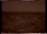
Lake, eastern terrace of Choiskai Mt., NM (Photo G205) | P0013 Herbert E. Gregory Photograph Collection | P0013n05_08_0680 |
| 10 |
 |
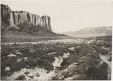
LaPlata cliff, 6 mi. south of Moore's. VI, 38. 1911 (Photo G210) | P0013 Herbert E. Gregory Photograph Collection | P0013n05_16_0697 |
| 11 |
 |
LaPlata cliffs 6± mi. south of Crystal, NM. Heald, photo. 1911 | P0013 Herbert E. Gregory Photograph Collection | P0013n05_20_0705 |
| 12 |
 |
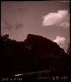
Lava cliffs near Whiskey Creek (Palisades). Heald, photo. 1911 (Photo N-M130) | P0013 Herbert E. Gregory Photograph Collection | P0013n05_83_0808 |
| 13 |
 |
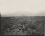
Lava-capped butte, northwest of Cedar Springs (Photo G246) | P0013 Herbert E. Gregory Photograph Collection | P0013n05_50_0749 |
| 14 |
 |
Same as Photo G240 (Chimney Butte, Photo G241) | P0013 Herbert E. Gregory Photograph Collection | P0013n05_47_0742 |
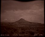
| 15 |
 |
Same as Photo G254. 1911 (White Cone, Photo G255) | P0013 Herbert E. Gregory Photograph Collection | P0013n05_56verso_0758 |
| 16 |
 |
Unconformity. Base of Dakota in section VI, 15. West of Manuelito, NM. 1911 (Photo G194) | P0013 Herbert E. Gregory Photograph Collection | P0013n05_02_0667 |
| 17 |
 |
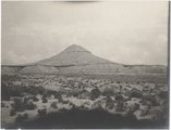
White Cone. 1911 (Photo G257) | P0013 Herbert E. Gregory Photograph Collection | P0013n05_57_0760 |
| 18 |
 |
[Whiskey Creek palisades] (Photo N-M130) | P0013 Herbert E. Gregory Photograph Collection | P0013n05_82_808_neg |
| 19 |
 |
Bad Lands, Cottonwood Wash. 1909 | P0013 Herbert E. Gregory Photograph Collection | P0013n05_16_696_neg |
| 20 |
 |
Erosion column Southeast Gallup, NM | P0013 Herbert E. Gregory Photograph Collection | P0013n05_01_662_neg |
| 21 |
 |
Lake, East terrace Choiskai Mt. | P0013 Herbert E. Gregory Photograph Collection | P0013n05_08_680_neg |
| 22 |
 |
Unconformity | P0013 Herbert E. Gregory Photograph Collection | P0013n05_02_667_neg |
| 23 |
 |
White Cone (Photo G256) | P0013 Herbert E. Gregory Photograph Collection | P0013n05_56_758_neg |
| 24 |
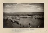 |
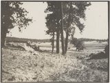
Sheep, Tanner's spring. Schwemberger, photo | P0013 Herbert E. Gregory Photograph Collection | P0013n05_62_0772 |
| 25 |
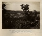 |
Todilto park looking northwest from east rim. Mrs. Gregory, photo. 1911 (Photo N-M116) | P0013 Herbert E. Gregory Photograph Collection | P0013n05_24_0709 |