|
|
Title | Collection Number And Name | Photo Number |
| 1 |
 |
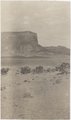
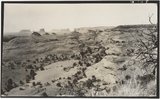
Erosion details, LaPlata strata, 3 mi. west of Moencopie, Ariz. (Pogue photo, 1910) | P0013 Herbert E. Gregory Photograph Collection | P0013n04_66_0634 |
| 2 |
 |
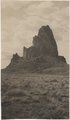
Agathla and Slim (Queen) Rock, Ariz., from S.E. (Photo G144) | P0013 Herbert E. Gregory Photograph Collection | P0013n04_21_0548 |
| 3 |
 |
Agathla, volcanic neck, between Chinlee, Ariz. and Oljato, Utah, 1910 (Photo G145) | P0013 Herbert E. Gregory Photograph Collection | P0013n04_21_0549 |
| 4 |
 |
Agathla, volcanic neck, between Chinlee, Ariz. and Oljato, Utah, 1910 (Photo G146) | P0013 Herbert E. Gregory Photograph Collection | P0013n04_22_0550 |
| 5 |
 |
Barohoini Bridge, looking downstream, i.e. northwest, 1910 (Photo G178A) | P0013 Herbert E. Gregory Photograph Collection | P0013n04_58verso_0609 |
| 6 |
 |
Barohoini Bridge, looking upstream, 1910 (Photo G179) | P0013 Herbert E. Gregory Photograph Collection | P0013n04_59_0610 |
| 7 |
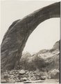 |
Barohoini Bridge, northeast arch, 1910 (Photo G180) | P0013 Herbert E. Gregory Photograph Collection | P0013n04_59_0611 |
| 8 |
 |
Branch of Navajo Canyon, Ariz., 1910 (Photo G184) | P0013 Herbert E. Gregory Photograph Collection | P0013n04_62_0623 |
| 9 |
 |
Butte, LaPlata on Dolores, 12± mi. south of Oljato, Utah. Agathla Needle in distance, 1910 | P0013 Herbert E. Gregory Photograph Collection | P0013n04_33_0562A |
| 10 |
 |
Cliff, LaPlata on Dolores at mouth of Sagy at Sosi canyon, AZ. 1910 (Photo G166) | P0013 Herbert E. Gregory Photograph Collection | P0013n04_40_0577 |
| 11 |
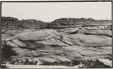 |
Cross-bedding, Moencopie (?) strata, 6± mi. northeast of Agathla Needle, Ariz., 1910 (Photo G157) | P0013 Herbert E. Gregory Photograph Collection | P0013n04_32_0569 |
| 12 |
 |
Dinosaur bone in McElmo strata, Yellow Jacket creek, 3± miles north of Holly's ranch, McElmo valley, Colorado. 1910 (Photo N-M77) | P0013 Herbert E. Gregory Photograph Collection | P0013n04_04_0518 |
| 13 |
 |
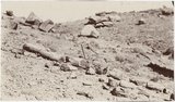
Dinosaur tracks, Navajo Canyon, Ariz., 1910 (Photo G185) | P0013 Herbert E. Gregory Photograph Collection | P0013n04_63_0626 |
| 14 |
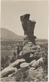 |
Erosion pillar, McElmo valley, 15± miles west of Cortez, Colorado. 1910 | P0013 Herbert E. Gregory Photograph Collection | P0013n04_01_0511 |
| 15 |
 |
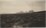
General view of upper Moencopie strata, looking northeast toward Monument Pass. Taken from a point 8± mi. northeast of Agathla Needle, Ariz., 1910 (Photo G158) | P0013 Herbert E. Gregory Photograph Collection | P0013n04_32_0560A |
| 16 |
 |
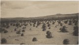
Grass between Monument Pass and Oljato, Utah. Moencopie strata (capped by Shinarump?) in distance, 1910 (Photo N-M82) | P0013 Herbert E. Gregory Photograph Collection | P0013n04_14_0537 |
| 17 |
 |
Joints in LaPlata sandstone. Head of Pahute canyon, UT. 1910 (Photo G183) | P0013 Herbert E. Gregory Photograph Collection | P0013n04_62_0622 |
| 18 |
 |
McElmo strata, Holly's ranch, McElmo valley, Colorado, 33± miles west of Cortez, Colorado. 1910 (Photo G-125) | P0013 Herbert E. Gregory Photograph Collection | P0013n04_03_0515 |
| 19 |
 |
McElmo strata, north bank of San Juan River, 10± mi. below Aneth, Utah, 1910 (Photo G129) | P0013 Herbert E. Gregory Photograph Collection | P0013n04_06_0521 |
| 20 |
 |
Method of trapping coyotes, Oljato, Utah, 1910 (Photo G141) | P0013 Herbert E. Gregory Photograph Collection | P0013n04_19_0544 |
| 21 |
 |
Monocline, LaPlata over Dolores east face of Skeleton Mesa, 15± mi. north of Marsh Pass, Ariz., 1910 (Photo G154) | P0013 Herbert E. Gregory Photograph Collection | P0013n04_30_0566 |
| 22 |
 |
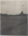
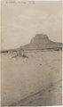
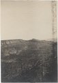
Monument Pass, Utah, from west. 1910 (Photo G137) | P0013 Herbert E. Gregory Photograph Collection | P0013n04_12_0534 |
| 23 |
 |
Monument Pass, Utah, from west. 1910 (Photo N-M81) | P0013 Herbert E. Gregory Photograph Collection | P0013n04_11_0533 |
| 24 |
 |
Mud cracks, McElmos valley, Colorado. 1910 (Photo G-122) | P0013 Herbert E. Gregory Photograph Collection | P0013n04_01_0512 |
| 25 |
 |
Navajo dry farming, Laguna Creek valley near Marsh Pass, Ariz., 1910 (Photo G160) | P0013 Herbert E. Gregory Photograph Collection | P0013n04_34_0564A |