Home
Browse
Ask Us
Chat
Harmful Language Statement
Log in
Advanced Search
Year
1899
1900
1901
1902
1903
1904
1905
1906
1907
1908
1909
1910
1911
1912
1913
1914
1915
1916
1917
1918
1919
1920
1921
1922
1923
1924
1925
1926
1927
1928
1929
1930
1931
1932
1933
1934
1935
1936
1937
1938
1939
TO
1899
1900
1901
1902
1903
1904
1905
1906
1907
1908
1909
1910
1911
1912
1913
1914
1915
1916
1917
1918
1919
1920
1921
1922
1923
1924
1925
1926
1927
1928
1929
1930
1931
1932
1933
1934
1935
1936
1937
1938
1939
Type
Image
228
Image/StillImage
143
Format
image/jpeg
369
application/pdf
2
Collection
Photo Archives
228
UAIDA Main Collection
143
Filters:
Collection Name:
"Herbert E. Gregory"
Keywords:
"Native Americans"
201
-
225
of
371
<
4
5
6
7
8
9
10
11
12
13
>
Gallery view
Number of results to display per page
10
25
50
100
200
Sort by Relevance
Sort by Title A-Z
Sort by Title Z-A
Sort by Date Ascending
Sort by Date Descending
Sort by Last Modified Ascending
Sort by Last Modified Descending
Title
Date
Type
Setname
201
Hopi Indian 1900
1900
Image
uum_map
202
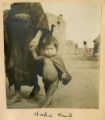
Hopi kid
1900
Image
uum_map
203
Hopi man + woman Bureau of Ethnology
Image/StillImage
uaida_main
204
Hopi man and woman, Bureau of Ethnology
1909
Image
uum_map
205
Hopi man holding melon, 1900
1900
Image
uum_map
206
Hopi scene, Oraibi, 1900
1900
Image
uum_map
207
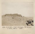
Hopi village. Mi-shong-i-nivi, Ariz. 1909
1909
Image
uum_map
208
Hopi woman washing in natural basin on hill near the spring. She brought water in nearby olla
1915
Image
uum_map
209
Hopi women on the trail to Mishonginovi, AZ
1915
Image
uum_map
210
Hopis at altar. Ariz. (Breakfasting near altar. Hopi Indians)
1909
Image
uum_map
211
Hopis Bureau of Ethnology
Image/StillImage
uaida_main
212
Hopis, Bureau of Ethnology
1909
Image
uum_map
213
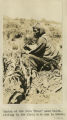
Indian at the farm 'Urco' near Calca, sitting in the field with how in hands.
1912; 1913; 1914; 1915
Image
uum_map
214
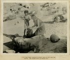
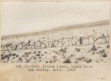
Indian fence, upper Chinle Valley, Ariz. 1909
1909
Image
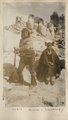
uum_map
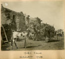
215
Indian gathering firewood on mountain-side above Calca.
1911
Image
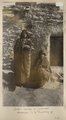
uum_map
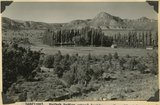
216
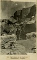
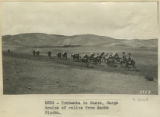
Indian gathering firewood on mountain-side above Calca.
1912
Image
uum_map
217
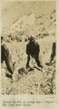
Indian in act of using how-'Urco'-The farm near Calca.
1912; 1913; 1914; 1915
Image
uum_map
218
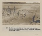
Indian monuments on the San Juan river. Paiute Indian Reservation. Meaning unknown. Douglass, photo.
1909
Image
uum_map
219
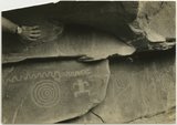
Indian pictographs near Mt. Carmel road.
1930; 1931; 1932; 1933; 1934; 1935; 1936; 1937
Image
uum_map
220
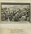
Indians at Fourth of July celebrations, Farmington, New Mexico, Navajo Indians, Farmington, NM. Notice the white 'Stetsons;' the Utes have black ones
1899
Image
uum_map
221
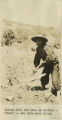
Indigenous Quechua with hoe for farming
1912; 1913; 1914; 1915
Image
uum_map
222
Interior hogan, Cornfields, 1909
1909
Image
uum_map
223
Interior Navajo summer hogan, San Juan Valley
1915
Image
uum_map
224
Kaibab Indian School looking north. Alluvial flats at head of Two Mile Wash. Branch of Sevier fault passes between Navajo (left distance) and Chinle-Navajo (middle distance), Mohave County, AZ. 1939
1939
Image
uum_map
225
Kaibab Indian School near Moccasin looking northeast toward head of Two Mile Wash. Deep alluvial fill. Moenkopi capped by Shinarump (upper right), Chinle and Glen Canyon beds cliffs at upper left and middle distance (Lambs Point). Branch of Sevier fault crosses divide between Two Mile Wash and Sand Creek at base of Indian Point (left middle), Mohave County, AZ. 1939
1939
Image
uum_map
201
-
225
of
371
<
4
5
6
7
8
9
10
11
12
13
>