Home
Browse
Ask Us
Chat
Harmful Language Statement
Log in
Advanced Search
Year
1872
1873
1874
1875
1876
1877
1878
1879
1880
1881
1882
1883
1884
1885
1886
1887
1888
1889
1890
1891
1892
1893
1894
1895
1896
1897
1898
1899
1900
1901
1902
1903
1904
1905
1906
1907
1908
1909
1910
1911
1912
1913
1914
1915
1916
1917
1918
1919
1920
1921
1922
1923
1924
1925
1926
1927
1928
1929
1930
1931
1932
1933
1934
1935
1936
1937
1938
1939
1940
1941
1942
1943
1944
1945
1946
1947
1948
1949
1950
1951
1952
1953
1954
1955
1956
1957
1958
1959
1960
1961
1962
1963
1964
1965
1966
1967
1968
1969
1970
1971
1972
1973
1974
1975
1976
1977
1978
1979
1980
1981
1982
1983
1984
1985
1986
1987
1988
1989
1990
1991
1992
1993
TO
1872
1873
1874
1875
1876
1877
1878
1879
1880
1881
1882
1883
1884
1885
1886
1887
1888
1889
1890
1891
1892
1893
1894
1895
1896
1897
1898
1899
1900
1901
1902
1903
1904
1905
1906
1907
1908
1909
1910
1911
1912
1913
1914
1915
1916
1917
1918
1919
1920
1921
1922
1923
1924
1925
1926
1927
1928
1929
1930
1931
1932
1933
1934
1935
1936
1937
1938
1939
1940
1941
1942
1943
1944
1945
1946
1947
1948
1949
1950
1951
1952
1953
1954
1955
1956
1957
1958
1959
1960
1961
1962
1963
1964
1965
1966
1967
1968
1969
1970
1971
1972
1973
1974
1975
1976
1977
1978
1979
1980
1981
1982
1983
1984
1985
1986
1987
1988
1989
1990
1991
1992
1993
Type
Image
3,451
Image/StillImage
143
Format
image/jpeg
3,594
Collection
Photo Archives
3,451
UAIDA Main Collection
143
Filters:
Collection Name:
"Herbert E. Gregory"
Format:
"image/jpeg"
576
-
600
of
3,594
<
19
20
21
22
23
24
25
26
27
28
>
Gallery view
Number of results to display per page
10
25
50
100
200
Sort by Relevance
Sort by Title A-Z
Sort by Title Z-A
Sort by Date Ascending
Sort by Date Descending
Sort by Last Modified Ascending
Sort by Last Modified Descending
Title
Date
Type
Setname
576
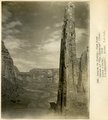
Canyon de Chelly, view down stream at "The Captains" (Moencopie strata), 1909 (W. C. Mendenhall, photo, U.S.G.S.)
1909
Image
uum_map
577
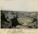
Canyon de Chelly, view from rim near mouth, 1909 (M. R. Campbell, photo, U.S.G.S.)
1909
Image
uum_map
578
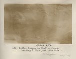
Canyon de Chelly. Cross-bedding (III-9 just like this) (Photo G374)
1913
Image
uum_map
579
Canyon de Chelly. Cross-bedding (III-9 just like this) (Photo G374)
1913
Image
uum_map
580
Canyon de Chelly. Portion of wall, Shinarump on top (Photo G375)
1913
Image
uum_map
581
Canyon de Chelly. Shinarump capping Permian (Photo G373)
1913
Image
uum_map
582
Canyon de Chelly. Shinarump capping Permian (Photo G373)
1913
Image
uum_map
583
Canyon de Chelly. VII, 26 (Photo N-M131)
1911
Image
uum_map
584
Canyon de Chelly. Wall and sand dune (Photo G376)
1913
Image
uum_map
585
Canyon del Muerto, 2± mi. above mouth (Moencopie strata), 1909 (W. C. Mendenhall, photo, U.S.G.S.)
1909
Image
uum_map
586
Canyon in gravels near Mormon Point
1925
Image
uum_map
587
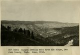
Canyon leading west from Elk Ridge, San Juan County, Utah. June, 1915.
1915
Image
uum_map
588
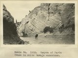
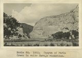
Canyon of Paria Creek in white Navajo sandstone
1922
Image
uum_map
589
Canyon of Paria Creek in white Navajo sandstone
1915
Image
uum_map
590
Canyon of San Juan River from Honaker trail, San Juan Oil Field, 600 ft. below top.
1909
Image
uum_map
591
Canyon of San Juan River from Honaker trail, San Juan Oil Field. Looking north from a point 600 ft. below top. Goodridge Formation.
1909
Image
uum_map
592
Capitol Reef wash, cut in Navajo sandstone, Wayne County, Utah, 1935.
1935
Image
uum_map
593
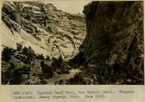
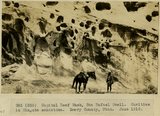
Capitol Reef Wash, San Rafael Swell. Wingate sandstone. Emery County, Utah. June 1918.
1918
Image
uum_map
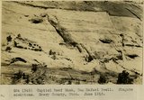
594
Capitol Reef Wash, San Rafael Swell. Wingate sandstone. Emery County, Utah. June 1918.
1918
Image
uum_map
595
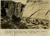
Capitol Reef Wash, San Rafael Swell. Cavities in Wingate sandstone. Emery County, UT. June 1918
1918
Image
uum_map
596
Capitol Reef Wash, San Rafael Swell. Navajo sandstone. Emery Co., UT. June 1918. Stream cutting through monocline
1918
Image
uum_map
597
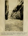
Capitol Reef Wash, San Rafael Swell. Wingate sandstone. Emery County, UT. June 1918
1918
Image
uum_map
598
Capitol Reef, looking SE down Sand Creek from point two miles west of Fruita. Moenkopi foreground; Shinarump-Navajo in cliffs; Henry Mountains in distance. Wayne County, Utah, 1937.
1937
Image
uum_map
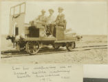
599
Car for inspection use on desert cattle railway, South Australia, 1916
1916
Image
uum_map
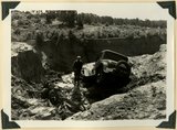
600
Car washed into a ravine by flood. Skutumpah-Swallow Park road
1940
Image
uum_map
576
-
600
of
3,594
<
19
20
21
22
23
24
25
26
27
28
>