Home
Browse
Ask Us
Chat
Harmful Language Statement
Log in
Advanced Search
Year
1872
1873
1874
1875
1876
1877
1878
1879
1880
1881
1882
1883
1884
1885
1886
1887
1888
1889
1890
1891
1892
1893
1894
1895
1896
1897
1898
1899
1900
1901
1902
1903
1904
1905
1906
1907
1908
1909
1910
1911
1912
1913
1914
1915
1916
1917
1918
1919
1920
1921
1922
1923
1924
1925
1926
1927
1928
1929
1930
1931
1932
1933
1934
1935
1936
1937
1938
1939
1940
1941
1942
1943
1944
1945
1946
1947
1948
1949
1950
1951
1952
1953
1954
1955
1956
1957
1958
1959
1960
1961
1962
1963
1964
1965
1966
1967
1968
1969
1970
1971
1972
1973
1974
1975
1976
1977
1978
1979
1980
1981
1982
1983
1984
1985
1986
1987
1988
1989
1990
1991
1992
1993
TO
1872
1873
1874
1875
1876
1877
1878
1879
1880
1881
1882
1883
1884
1885
1886
1887
1888
1889
1890
1891
1892
1893
1894
1895
1896
1897
1898
1899
1900
1901
1902
1903
1904
1905
1906
1907
1908
1909
1910
1911
1912
1913
1914
1915
1916
1917
1918
1919
1920
1921
1922
1923
1924
1925
1926
1927
1928
1929
1930
1931
1932
1933
1934
1935
1936
1937
1938
1939
1940
1941
1942
1943
1944
1945
1946
1947
1948
1949
1950
1951
1952
1953
1954
1955
1956
1957
1958
1959
1960
1961
1962
1963
1964
1965
1966
1967
1968
1969
1970
1971
1972
1973
1974
1975
1976
1977
1978
1979
1980
1981
1982
1983
1984
1985
1986
1987
1988
1989
1990
1991
1992
1993
Type
Image
3,451
Image/StillImage
143
Format
image/jpeg
3,594
Collection
Photo Archives
3,451
UAIDA Main Collection
143
Filters:
Collection Name:
"Herbert E. Gregory"
Format:
"image/jpeg"
501
-
525
of
3,594
<
16
17
18
19
20
21
22
23
24
25
>
Gallery view
Number of results to display per page
10
25
50
100
200
Sort by Relevance
Sort by Title A-Z
Sort by Title Z-A
Sort by Date Ascending
Sort by Date Descending
Sort by Last Modified Ascending
Sort by Last Modified Descending
Title
Date
Type
Setname
501
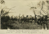
Camels traveling water wagon, 340 M west Port Augusta, 1916
1916
Image
uum_map
502
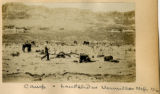
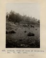
Camp & landslides, Vermillion Cliffs 1900
1900
Image
uum_map
503
Camp 3+ mi. east of Agathla Needle, Ariz. (Photo N-M93)
1910
Image
uum_map
504
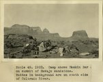
Camp above Meskin Bar on summit of navajo sandstone. Buttes in background are on south side of Colorado
1922
Image
uum_map
505
Camp and Indian pasture, Da-dat-soe. East terrace of Choiskai Mt., NM. 1911
1911
Image
uum_map
506
Camp at base of Baigaiche Mt. VI, 45. 1911 (Photo N-M113)
1911
Image
uum_map
507
Camp at head of To-chin-Sin Canyon
1913
Image
uum_map
508
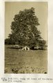
Camp at Liston Ranch between Escalante and Henrieville
1922
Image
uum_map
509
Camp at Reservoir 2 miles south of Fredonia. Dr. and Mrs. Noble and three packers. Coconino County, AZ. 1922
1922
Image
uum_map
510
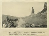
Camp at Star Ranch, Henry Mountains, Garfield County, Utah, June, 1915.
1915
Image
uum_map
511
Camp by Sonsala Buttes near Whiskey Creek. Heald, photo. 1911 (Photo N-M129)
1911
Image
uum_map
512
Camp Creek near its mouth in Hurricane Cliffs. Navajo sandstone overlain by Carmel, Entrada, Curtis and Winsor. Pine Valley mountains (right distance), Washington County, UT, 1939
1939
Image
uum_map
513
Camp in canyon of Paria Creek in white Navajo sandstone. Dorthy and Dinah Watts
1922
Image
uum_map
514
Camp in cave by spring, 8+ mi. southeast of Agathla Needle, 1910 (Photo N-M104)
1910
Image
uum_map
515
Camp in Dry Valley near Henrieville. Garfield County, UT. June 1918
1915
Image
uum_map
516
Camp in dune areas, Central Australia, 1916
1916
Image
uum_map
517
Camp in Escalante Desert. Kaiparowitz Plateau in background
1922
Image
uum_map
518
Camp in floor of ancient lake bed; mesa of Navajo sandstone in background. Kitchen Rach, Kane County, Utah, 1931.
1931
Image
uum_map
519
Camp in Kanab Canyon 2 miles below mouth of Snake Gulch
1915
Image
uum_map
520
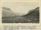
Camp in Kanab Canyon 2 miles below mouth of Snake Gulch. Gregory rolling bed. AZ. 1922
1922
Image
uum_map
521
Camp in Lake Canyon. Walls of Navajo Sandstone. San Juan County, UT, 1927
1927
Image
uum_map
522
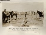
Camp in Pueblo Colorado Wash. Case digging for water (Photo N-M167)
1913
Image
uum_map
523
Camp in San Juan Canyon near mouth of Johns Canyon. Lower Part of wall formed by Goodridge formation and upper part by Moonlight sandstone and Hermit shale. San Juan County, UT. 1921
1921
Image
uum_map
524
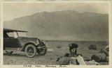
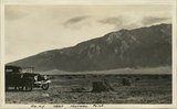
Camp near Mormon Point
1925
Image
uum_map
525
Camp near Mormon Point
1925
Image
uum_map
501
-
525
of
3,594
<
16
17
18
19
20
21
22
23
24
25
>