|
|
Title | Collection Number And Name | Photo Number |
| 626 |
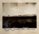 |
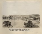
Monument Pass. Utah, from west, 1910 (Photo N-M81) | P0013 Herbert E. Gregory Photograph Collection | P0013n04_11_0533 |
| 627 |
 |
Monument Pass, Utah from west (Moencopie strata), 1910 (Photo G137) | P0013 Herbert E. Gregory Photograph Collection | P0013n04_12_0534 |
| 628 |
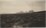 |
Monument Pass, Utah, from west. 1910 (Photo G137) | P0013 Herbert E. Gregory Photograph Collection | P0013n04_12_0534 |
| 629 |
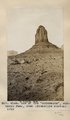 |
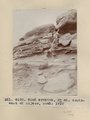
One of the "monuments," Monument Pass, Utah (Moencopie strata), 1910 (Photo G138) | P0013 Herbert E. Gregory Photograph Collection | P0013n04_12_0535 |
| 630 |
 |
One of the monuments, Monument Pass, Utah. Moencopie strata. 1910 (Photo G138) | P0013 Herbert E. Gregory Photograph Collection | P0013n04_12_0535 |
| 631 |
 |
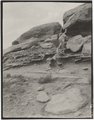
One of the "monuments," Monument Pass, Utah (Moencopie strata), 1910 (Photo G139) | P0013 Herbert E. Gregory Photograph Collection | P0013n04_13_0536 |
| 632 |
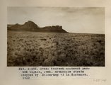 |
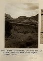
Grass between Monument Pass and Oljato, Utah. Moencopie strata (capped by Shinarump?) in distance, 1910 (Photo N-M82) | P0013 Herbert E. Gregory Photograph Collection | P0013n04_14_0537 |
| 633 |
 |
Grass between Monument Pass and Oljato, Utah. Moencopie strata (capped by Shinarump?) in distance, 1910 (Photo N-M82) | P0013 Herbert E. Gregory Photograph Collection | P0013n04_14_0537 |
| 634 |
 |
Wind-swept mesa, Shinarump, at Oljato, Utah (S.M. Young photo) | P0013 Herbert E. Gregory Photograph Collection | P0013n04_15_0538 |
| 635 |
 |
Wind erosion, 3+ mi. southwest of Oljato, Utah, 1910 (Photo G140) | P0013 Herbert E. Gregory Photograph Collection | P0013n04_16_0539 |
| 636 |
 |
Wind erosion, 3± miles southwest of Oljato, Utah, 1910 (Photo G140) | P0013 Herbert E. Gregory Photograph Collection | P0013n04_16_0539 |
| 637 |
 |
Cross-bedding in Moencopie, capped by Shinarump, Oljato, Utah, 1910. | P0013 Herbert E. Gregory Photograph Collection | P0013n04_16_0540 |
| 638 |
 |
San Francisco Mountain (Photo N-M83a) | P0013 Herbert E. Gregory Photograph Collection | P0013n04_17_0541 |
| 639 |
 |
Structure, Dolores and La Plata, looking west from Oljato, Utah, 1910 (Photo N-M84) | P0013 Herbert E. Gregory Photograph Collection | P0013n04_18_0542 |
| 640 |
 |
Structure, Dolores and La Plata, looking west from Oljato, Utah, 1910 (Photo N-M84) | P0013 Herbert E. Gregory Photograph Collection | P0013n04_18_0542 |
| 641 |
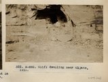 |
Cliff Dwelling near Oljato, Utah (Photo N-M85) | P0013 Herbert E. Gregory Photograph Collection | P0013n04_18_0543 |
| 642 |
 |
Method of trapping coyotes, Oljato, Utah, 1910 (Photo G141) | P0013 Herbert E. Gregory Photograph Collection | P0013n04_19_0544 |
| 643 |
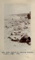 |
Method of trapping coyotes, Oljato, Utah, 1910 (Photo G141) | P0013 Herbert E. Gregory Photograph Collection | P0013n04_19_0544 |
| 644 |
 |
Piute woman with ollas, Oljato, Utah (Photo G142) | P0013 Herbert E. Gregory Photograph Collection | P0013n04_19_0545 |
| 645 |
 |
Indian trading post, John Wetherill, Oljato, Utah, 1910 (Photo G143) | P0013 Herbert E. Gregory Photograph Collection | P0013n04_20_0546 |
| 646 |
 |
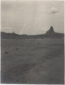
Agathla and Slim (Queen) Rock, Ariz., from S.E. (Photo N-M86) | P0013 Herbert E. Gregory Photograph Collection | P0013n04_20_0547 |
| 647 |
 |
Agathla and Slim (Queen) Rock, Ariz., from S.E. (Photo G144) | P0013 Herbert E. Gregory Photograph Collection | P0013n04_21_0548 |
| 648 |
 |
Agathla and Slim (Queen) Rock, Ariz., from S.E. (Photo G144) | P0013 Herbert E. Gregory Photograph Collection | P0013n04_21_0548 |
| 649 |
 |
Agathla, volcanic neck, between Chinlee, Ariz. and Oljato, Utah, 1910 (Photo G145) | P0013 Herbert E. Gregory Photograph Collection | P0013n04_21_0549 |
| 650 |
 |
Agathla, volcanic neck, between Chinlee, Ariz. and Oljato, Utah, 1910 (Photo G145) | P0013 Herbert E. Gregory Photograph Collection | P0013n04_21_0549 |