Home
Browse
Ask Us
Chat
Harmful Language Statement
Log in
Photo Archives
Advanced Search
About
Over 70,000 photos covering a variety of topics from Marriott Library Special Collections
Year
1875
1876
1877
1878
1879
1880
1881
1882
1883
1884
1885
1886
1887
1888
1889
1890
1891
1892
1893
1894
1895
1896
1897
1898
1899
1900
1901
1902
1903
1904
1905
1906
1907
1908
1909
1910
1911
1912
1913
1914
1915
1916
1917
1918
1919
1920
1921
1922
1923
1924
1925
1926
1927
1928
1929
1930
1931
1932
1933
1934
1935
1936
1937
1938
1939
1940
1941
1942
1943
1944
1945
TO
1875
1876
1877
1878
1879
1880
1881
1882
1883
1884
1885
1886
1887
1888
1889
1890
1891
1892
1893
1894
1895
1896
1897
1898
1899
1900
1901
1902
1903
1904
1905
1906
1907
1908
1909
1910
1911
1912
1913
1914
1915
1916
1917
1918
1919
1920
1921
1922
1923
1924
1925
1926
1927
1928
1929
1930
1931
1932
1933
1934
1935
1936
1937
1938
1939
1940
1941
1942
1943
1944
1945
Type
Image
70
Format
application/pdf
70
Collection
Photo Archives
70
Filters:
Collection Name:
"Herbert E. Gregory"
Format:
"application/pdf"
1
-
25
of
70
<
1
2
3
>
Gallery view
Number of results to display per page
10
25
50
100
200
Sort by Relevance
Sort by Title A-Z
Sort by Title Z-A
Sort by Date Ascending
Sort by Date Descending
Sort by Last Modified Ascending
Sort by Last Modified Descending
Title
Date
Type
1
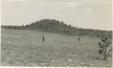
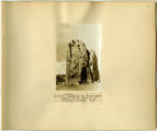
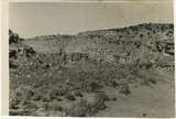
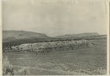
Bowers Knoll; Volcano viewed from northwest. Garfield County, UT. 1944
1944
Image
2
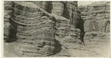
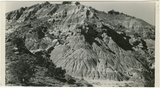
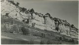
Cretaceous shales (tropic formation). Antimony Canyon, Garfield County, UT. 1943
1943
Image
3
Herbert E. Gregory Book 12: Colorado Plateau, Province, 1942-1944
1942; 1943; 1944
Image
4
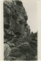
West wall of Seaman Wash
1944
Image
5
Herbert E. Gregory Book 2: Navajo-Hopi, San Juan 1909
1909
Image
6
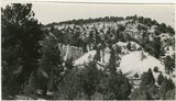
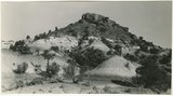
Brian Head formation, branch of Asay Creek; lies beneath basalt flows. Garfield County, UT, 1944
1944
Image
7
Chinle formation, Petrified Forest member. Head of Fossil Wood Creek. Kane County, UT. 1943
1943
Image
8
Navajo sandstone north end of No Man's Mesa. Kane County, UT. 1943
1943
Image
9
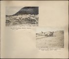
Herbert E. Gregory Book 13: Photographs taken on Yale Peruvian Expeditions, 1911-1915
1911; 1912; 1913; 1914; 1915; 1916; 1926
Image
10
Kaibab limestone (lower wall,left, breccia (marks unconformable contact), and basal Moenkopi limestone and shales. Mouth of Kaibab Gulch. Kane County, UT, 1944
1944
Image
11
Moenkopi formation: Shnabkaib member (lower part), upper red sandstone (upper middle), Shinarump conglomerate (top). East side of Seamans Wash, Kane County, UT. 1943
1943
Image
12
Sevier River formation overlaid by basalt near mouth of Corral Creek on Highway 89, 2 miles east of Panguitch. Garfield County, UT. 1944
1944
Image
13
Unconformity between Moenkopi formation (lower part) and Shinarump conglomerate. Upper Chinle beds, middle top. Near mouth of Road Canyon. Kane County, UT. 1943
1943
Image
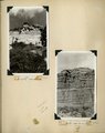
14
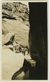
Warm Creek Canyon, June, 1915.
1915
Image
15
Herbert E. Gregory Book 3: Navajo-Hopi, Arizona-New Mexico, 1909
1909
Image
16
Herbert E. Gregory Book 5: Navajo, 1911
1911
Image
17
Herbert E. Gregory Book 11: Colorado Plateau, 1938-1942
1938; 1939; 1940; 1941; 1942
Image
18
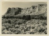
Mesa capped by Dakota sandstone eroded from upper Jurassic Winsor (?) formation. Head of Ash Creek. Kane County, UT
1944
Image
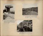
19
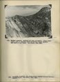
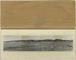
Panorama, Red Wall and Baigaiche, looking across Red Lake (Photo G-378-380)
1913
Image
20
Section of the Shinarump Cliffs (middle distance), east of Pioneer Gap. Shinarump conglomerate exposed by erosion of Moenkopi formation below and the basal strata of the Chinle formation above. Upper Chinle sandstones form Vermilion Cliffs (background).
1944
Image
21
Wingate sandstone, includes bed of limestone. Wall of Flood Canyon. Johnson Lakes. Kane County, UT. 1943
1943
Image
22
Herbert E. Gregory Book 1: Colorado Plateau and Grand Canyon 1900, Navajo-Hopi 1909
1900; 1909; 1928
Image
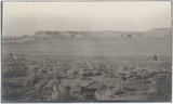
23
Panorama--4 photographs. Blue Springs meadows. A former valley leading to Mammoth Creek blocked by basalts from Miller Knoll (right skyline) became a lake that eventually cut an outlet northward through the Brian Head formation (upper left). Garfield County, UT, 1944
1944
Image
24
Herbert E. Gregory Book 2: Navajo-Hopi, San Juan 1909
1909
Image
25
Herbert E. Gregory Book 4: Navajo, San Juan, 1910
1910
Image
1
-
25
of
70
<
1
2
3
>