Home
Browse
Ask Us
Chat
Harmful Language Statement
Log in
Photo Archives
Advanced Search
About
Over 70,000 photos covering a variety of topics from Marriott Library Special Collections
Year
1875
1876
1877
1878
1879
1880
1881
1882
1883
1884
1885
1886
1887
1888
1889
1890
1891
1892
1893
1894
1895
1896
1897
1898
1899
1900
1901
1902
1903
1904
1905
1906
1907
1908
1909
1910
1911
1912
1913
1914
1915
1916
1917
1918
1919
1920
1921
1922
1923
1924
1925
1926
1927
1928
1929
1930
1931
1932
1933
1934
1935
1936
1937
1938
1939
1940
1941
1942
1943
1944
1945
TO
1875
1876
1877
1878
1879
1880
1881
1882
1883
1884
1885
1886
1887
1888
1889
1890
1891
1892
1893
1894
1895
1896
1897
1898
1899
1900
1901
1902
1903
1904
1905
1906
1907
1908
1909
1910
1911
1912
1913
1914
1915
1916
1917
1918
1919
1920
1921
1922
1923
1924
1925
1926
1927
1928
1929
1930
1931
1932
1933
1934
1935
1936
1937
1938
1939
1940
1941
1942
1943
1944
1945
Type
Image
70
Format
application/pdf
70
Collection
Photo Archives
70
Filters:
Collection Name:
"Herbert E. Gregory"
Format:
"application/pdf"
26
-
50
of
70
<
1
2
3
>
Gallery view
Number of results to display per page
10
25
50
100
200
Sort by Relevance
Sort by Title A-Z
Sort by Title Z-A
Sort by Date Ascending
Sort by Date Descending
Sort by Last Modified Ascending
Sort by Last Modified Descending
Title
Date
Type
26
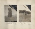
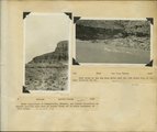
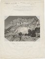
Herbert E. Gregory Book 6: Navajo, 1913
1913
Image
27
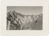
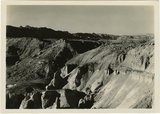
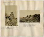
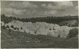
Ridge of uptilted strata
1940
Image
28
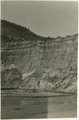
Johnson Creek. Old alluvial fill trenched 40 feet since 1915, Kane County, Utah, 1939
1939
Image
29
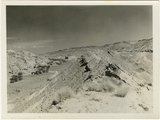
Eroded flank of the East Kaibab monocline at the junction of Paria River and Cottonwood Creek (left center). The sequence is Navajo (left), upper Jurassic (largely eroded), Dakota, Tropic, and Straight Cliffs. Kane County, UT, 1944
1944
Image
30
Flat lying Upper Jurassic (foreground) and Cretaceous strata bed abruptly upward against the Navajo on the flank of the East Kaibab monocline (left sky line). Table Cliffs (right sky line) is about 50 miles north. Paria Valley near Adairville. Kane County, UT. 1944
1944
Image
31
Herbert E. Gregory Book 10: San Juan, Zion, Capitol Reef, 1915-1938
1915; 1916; 1917; 1918; 1919; 1920; 1921; 1922; 1923; 1924; 1925; 1926; 1927; 1928; 1929; 1930; 1931; 1932; 1933; 1934; 1935; 1936; 1937; 1938
Image
32
Looking south, up dip, across West Clark Bench, Upper Jurassic and Dakota (butte), to the Paria Terrace, Navajo sandstone. Paria River, which passes through 'The Gap' is joined by Kaibab Creek. Kane County, UT. 1944
1944
Image
33
Panorama {c}. Flank of East Kaibab monocline, bordering alluvial floor of Paria Valley. Navajo sandstone (middle sky line), Upper Jurassic strata, and basal Cretaceous (left). Dips of 40 degrees decrease to 3 degrees within 1,000 feet. Kane County, UT, 1944
1944
Image
34
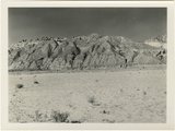
Navajo sandstone, part of White Cliffs, near head of Johnson Canyon, Kane Co., Utah, 1939
1939
Image
35
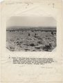
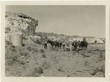
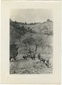
Herbert Gregory party at watering station in Paria Valley, Utah
1943
Image
36
Contact of Kayenta formation (foreground) and Navajo sandstone Park Wash above the mouth of Five Pines Wash. Kane County, UT. 1943
1943
Image
37
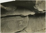
Indian pictographs near Mt. Carmel road.
1930; 1931; 1932; 1933; 1934; 1935; 1936; 1937
Image
38
Herbert E. Gregory Book 7: Navajo, 1913, 1914
1913; 1914
Image
39
Looking south (up dip) down the Paria River, which has widened its floor and dissected its borders in Upper Jurassic rocks (foreground) and cut a deep narrow canyon in the Navajo sandstone (background). Site of the abandoned Adairville. Kane County UT, 1944
1944
Image
40
Looking south along Paria River from the mouth of Shurtz Gorge. Navajo sandstone in East Kaibab monocline is overlaid with decreasing dips by Upper Jurassic (banked against the Navajo), Dakota, and Tropic (foreground and left sky line). Erosion surface (middle distance) bevels upturned rocks. Kane County, UT, 1944
1944
Image
41
Herbert E. Gregory Book 8: Arizona, Utah, Nevada, California, 1915-1922
1915; 1918; 1922; 1924
Image
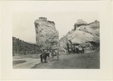
42
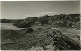
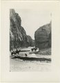
Paria Canyon, Utah
1943; 1944; 1945
Image
43
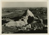
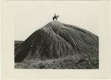
Mound of sedimentary material, vicinity of Paria River, Utah
1943; 1944; 1945
Image
44
Upper Box in Paria Canyon just south of Cannonville
1943; 1944; 1945
Image
45
Herbert E. Gregory Book 9: Utah, California, 1924-1928
1875; 1907; 1921; 1924; 1925; 1927; 1928
Image
46
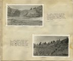
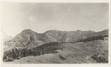
Panorama of head of Johnson Creek, from West Mountain. Abajo Mountains. 1915
1915
Image
47
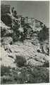
Sandstone outcrops, Paria Canyon, Utah
1943; 1944; 1945
Image
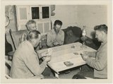
48
Card players, Paria Valley camp, 1943
1943
Image
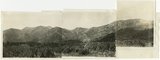
49
Panorama, looking west from Camp Jackson. West Peak in left center. Abajo Mountains. Utah, San Juan, 1915.
1915
Image
50
White rocks on road to Panquitch, Utah
1943; 1944; 1945
Image
26
-
50
of
70
<
1
2
3
>