Home
Browse
Ask Us
Chat
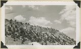
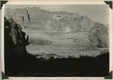
Harmful Language Statement
Log in
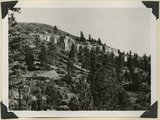
Photo Archives
Advanced Search
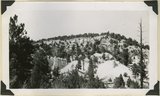
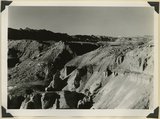
About
Over 70,000 photos covering a variety of topics from Marriott Library Special Collections
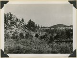
Year
1943
1944
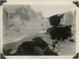
1945
TO
1943
1944
1945
Type
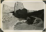
Image
71
Format
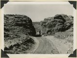
image/jpeg
71
Collection
Photo Archives
71
Filters:
Collection Name:
"Herbert E. Gregory"
Date:
"1944"
Format:
"image/jpeg"
1
-
25
of
71
<
1
2
3
>
Gallery view
Number of results to display per page
10
25
50
100
200
Sort by Relevance
Sort by Title A-Z
Sort by Title Z-A
Sort by Date Ascending
Sort by Date Descending
Sort by Last Modified Ascending
Sort by Last Modified Descending
Title
Date
Type
1
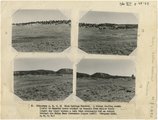
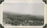
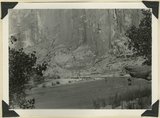
(Panorama A, B, C, D) Blue Springs Meadows. A stream leading south (left) to Mammoth Creek blocked by basalts from Miller Knoll (right sky line) became a lake that eventuallly cut an outlet through the Brian Head formation (upper left).
1944
Image
2
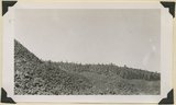
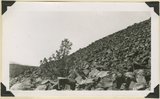
Basalt, head of Rock Creek. Old lava (foreground) and end of newer flow (center). Garfield County, UT, 1944
1944
Image
3
Blue Springs meadow at Leigh ranch. Stream from big springs (lower left) meanders across an ancient lake bed and escapes through a water gap (center distance). Garfield County, UT, 1944
1944
Image
4
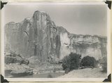
Brian Head formation at the 'Castles,' Castle Creek. Garfield County, UT, 1944
1944
Image
5
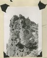
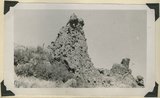
Brian Head formation at the 'Castles,' Castle Creek. Garfield County, UT, 1944. Details of erosion
1944
Image
6
Brian Head formation underlain by pink Wasatch limestone on Highway 89, 2± miles north of Castle Creek. Garfield County, UT, 1944
1944
Image
7
Brian Head formation, branch of Asay Creek; lies beneath basalt flows. Garfield County, UT, 1944
1944
Image
8
Brian Head formation, consolidated (white wall) and disintegrated (upper slopes), and pink Wasatch limestones (lowest slopes). Seamans Canyon west of Gravel Pass. Kane County, UT, 1944
1944
Image
9
Brian Head formation, consolidated (white wall) and disintegrated (upper slopes), and pink Wasatch limestones (lowest slopes). Seamans Canyon west of Gravel Pass. Kane County, UT, 1944
1944
Image
10
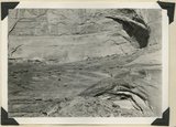
End of basalt flow in Black Rock Valley. White rocks (foreground) and left sky line (Haycock Mountain) of Brian Head formation. Garfield County, UT, 1944
1944
Image
11
End of basalt flow in Black Rock Valley. White rocks (foreground) and left sky line (Haycock Mountain) of Brian Head formation. Garfield County, UT, 1944
1944
Image
12
Eroded flank of the East Kaibab monocline at the junction of Paria River and Cottonwood Creek (left center). The sequence is Navajo (left), upper Jurassic (largely eroded), Dakota, Tropic, and Straight Cliffs. Kane County, UT, 1944
1944
Image
13
Escalante Canyon 2 miles below Big Bend. Walls of Navajo sandstone 800 feet high. Garfield, UT, 1944
1944
Image
14
Escalante Canyon down stream from Big Bend. Garfield County, UT, 1944
1944
Image
15
Escalante Canyon walls of Navajo sandstone at Big Bend camp. Moonlight view. Garfield County, UT, 1944
1944
Image
16
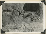
Escalante Canyon, cliff cave 3 miles above Cave Camp. Garfield County, UT, 1944
1944
Image
17
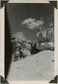
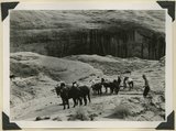
Escalante Canyon. Pueblo ruins in cliff cave. Navajo sandstone. Scale shown by horse. Garfield County, UT, 1944
1944
Image
18
Escalante Canyon. Sheer wall of Navajo sandstone 840 feet high. Garfield County, UT, 1944
1944
Image
19
Escalante River at Big Bend, flowing east. At times of high water the stream flows across Kayenta formation at the meander neck (lower right). Garfield County, UT, 1944
1944
Image
20
Escalante River at Big Bend, flowing west. After surrounding the tower of Navajo sandstone (center), the river comes within 300 feet of its east flowing section at the base of the wall (upper left). Garfield County, UT, 1944
1944
Image
21
Flat lying Upper Jurassic (foreground) and Cretaceous strata bed abruptly upward against the Navajo on the flank of the East Kaibab monocline (left sky line). Table Cliffs (right sky line) is about 50 miles north. Paria Valley near Adairville. Kane County, UT. 1944
1944
Image
22
Gap cut in Navajo sandstone by Kaibab Creek where it leaves its structural valley to cross East Kaibab monocline. Northward through the gap House Rock Valley and Kaibab Plateau are visible. Kane County, UT. 1944
1944
Image
23
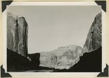
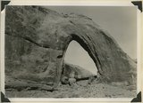
Gothic Arch. Width 174 feet, estimated height 190 feet. End of a buttress of Navajo sandstone resting on Kayenta. Soda Creek branch of Escalante River. Garfield County, UT, 1944
1944
Image
24
Head of Break Neck Trail down the south wall of Escalante Canyon (middle distance). Navajo sandstone. Garfield County, UT, 1944
1944
Image
25
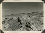
Igneous breccia in Brian Head formation(?), upper Panguitch Creek. Garfield County, UT, 1944
1944
Image
1
-
25
of
71
<
1
2
3
>