|
|
Title | Collection Number And Name | Photo Number |
| 1 |
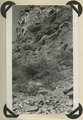 |
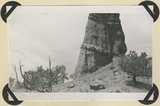
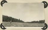
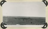
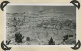
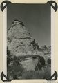
Parunuweap formation, Pliocene?, overlying Moenkopi beds (concealed by talus) and capped by basalt. Lower La Verkin Canyon, Washington County, UT, 1943 | P0013 Herbert E. Gregory Photograph Collection | P0013n12_007_2854 |
| 2 |
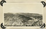 |
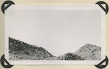
View looking northeast across Antimony Canyon. Cretaceous strata (foreground and middle distance) below igneous conglomerate and acidic lavas that form the surface of Aquarius Plateau. Garfield County, UT, 1943 | P0013 Herbert E. Gregory Photograph Collection | P0013n12_010_2855 |
| 3 |
 |
Entrada sandstone, regular bedded shaly phase overlain by undifferentiated Curtis and Winsor formations. Antimony Canyon, Garfield County, UT, 1943 | P0013 Herbert E. Gregory Photograph Collection | P0013n12_011_2856 |
| 4 |
 |
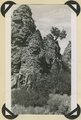
Erosion features in Entrada sandstone. Antimony Canyon, Garfield County, UT, 1943 | P0013 Herbert E. Gregory Photograph Collection | P0013n12_011_2857 |
| 5 |
 |
Erosion features in Entrada sandstone. Antimony Canyon, Garfield County, UT, 1943 | P0013 Herbert E. Gregory Photograph Collection | P0013n12_012_2858 |
| 6 |
 |
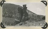
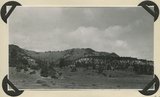
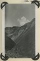
Brian Head formation capped by lava (rhyolite?): Cliff on upthrown side of Paunsaugunt fault. East fork of Sevier River near the mouth of Deer Creek. Garfield County, UT. 1943 | P0013 Herbert E. Gregory Photograph Collection | P0013n12_012_2859 |
| 7 |
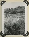 |
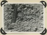
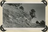
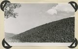
Detailed view of pumice conglomerate in the Brian Head formation, Casto Bluff, Garfield County, UT, 1943 | P0013 Herbert E. Gregory Photograph Collection | P0013n12_013_2860 |
| 8 |
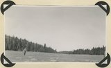 |
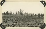
Glaciated surface showing (roche mountain): glade in spruce forest at top of Aquarius Plateau at altitude of 10,800 feet. Near the head of Antimony Creek, Garfield County, UT, 1943 | P0013 Herbert E. Gregory Photograph Collection | P0013n12_014_2861_1 |
| 9 |
 |
Glaciated surface showing (roche mountain): glade in spruce forest at top of Aquarius Plateau at altitude of 10,800 feet. Near the head of Antimony Creek, Garfield County, UT, 1943 | P0013 Herbert E. Gregory Photograph Collection | P0013n12_014_2861_2 |
| 10 |
 |
Burro Gap on East Fork of Sevier River above mouth of Deer Creek. Locus of Paunsaugunt fault; upthrow on east right. Garfield County, UT. 1943 | P0013 Herbert E. Gregory Photograph Collection | P0013n12_015_2862 |
| 11 |
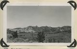 |
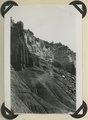
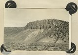
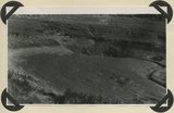
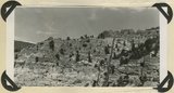
View looking north across Casto Canyon toward the face of the Sevier Plateau. Slope of Brian Head formation beneath gravels (foreground) and in steep white slope ( middle distance) is capped by igneous conglomerates and lavas. Garfield County, UT. 1943 | P0013 Herbert E. Gregory Photograph Collection | P0013n12_015_2863 |
| 12 |
 |
Detailed view of pumice conglomerate in the Brian Head formation, Casto Bluff, Garfield County, UT, 1943 | P0013 Herbert E. Gregory Photograph Collection | P0013n12_017_2864 |
| 13 |
 |
Surface of Markagunt Plateau looking west from the head of Deedy Hollow. Coated with gravel from decomposed igneous conglomerates and rhyolite. Garfield County, UT. 1943 | P0013 Herbert E. Gregory Photograph Collection | P0013n12_017_2865 |
| 14 |
 |
Upper Brian Head formation near the mouth of Deedy Hollow. Garfield County, UT. 1943 | P0013 Herbert E. Gregory Photograph Collection | P0013n12_018_2866 |
| 15 |
 |
Little valleys near head of Pole Creek. Lower Brian Head formation capped by decomposed igneous conglomerate. Garfield County, UT. 1943 | P0013 Herbert E. Gregory Photograph Collection | P0013n12_019_2867 |
| 16 |
 |
Brian Head formation in the walls of Panguitch Canyon near power house. Garfield County, UT. 1943 | P0013 Herbert E. Gregory Photograph Collection | P0013n12_019_2868 |
| 17 |
 |
Surface of recent basalt flow north of Duck Creek sinks. Garfield County, UT. 1943 | P0013 Herbert E. Gregory Photograph Collection | P0013n12_020_2869 |
| 18 |
 |
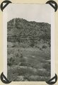
South sink of Duck Creek. Entire stream enters hole in Wasatch limestone. Garfield County, UT. 1943 | P0013 Herbert E. Gregory Photograph Collection | P0013n12_021_2870 |
| 19 |
 |
End of recent basalt flow at the race track, Panguitch Lake. Garfield County, UT, 1943 | P0013 Herbert E. Gregory Photograph Collection | P0013n12_021_2871 |
| 20 |
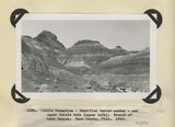 |
Chile formation, Petrified Forest member, and upper Chinle beds ( upper left). Branch of Road Canyon. Kane County, UT. 1943 | P0013 Herbert E. Gregory Photograph Collection | P0013n12_022_2872 |
| 21 |
 |
Chinle formation, Petrified Forest member. Head of Fossil Wood Creek. Kane County, UT. 1943 | P0013 Herbert E. Gregory Photograph Collection | P0013n12_022_2873 |
| 22 |
 |
Chinle formation 2 miles northwest abandoned village of Paria. Kane County, UT. 1943 | P0013 Herbert E. Gregory Photograph Collection | P0013n12_023_2874 |
| 23 |
 |
Chinle formation, upper red beds near mouth of Box Elder Canyon. Kane County, UT. 1943 | P0013 Herbert E. Gregory Photograph Collection | P0013n12_024_2875 |
| 24 |
 |
Chinle formation, upper red beds capped by remnants of Wingate sandstone. Five Pines Wash. Kane County, UT. 1943 | P0013 Herbert E. Gregory Photograph Collection | P0013n12_024_2876 |
| 25 |
 |
Wingate sandstone, includes bed of limestone. Wall of Flood Canyon. Kane County, UT. 1943 | P0013 Herbert E. Gregory Photograph Collection | P0013n12_025_2877 |