Home
Browse
Ask Us
Chat
Harmful Language Statement
Log in
Photo Archives
Advanced Search
About
Over 70,000 photos covering a variety of topics from Marriott Library Special Collections
Year
1938
1939
1940
TO
1938
1939
1940
Type
Image
111
Format
image/jpeg
111
Collection Name
Herbert E. Gregory
111
Filters:
Collection Name:
"Herbert E. Gregory"
Date:
"1939"
Format:
"image/jpeg"
Collection:
"uum_map"
76
-
100
of
111
<
1
2
3
4
5
>
Gallery view
Number of results to display per page
10
25
50
100
200
Sort by Relevance
Sort by Title A-Z
Sort by Title Z-A
Sort by Date Ascending
Sort by Date Descending
Sort by Last Modified Ascending
Sort by Last Modified Descending
Sort by Photo Number
Title
Collection Number And Name
Photo Number
76
Lake, one of three in LaVanger Wash. Surrounding trills Wasatch formation. Original obstruction of stream by alluvial fans made permanent by artificial dam, Kane County, UT, 1939
P0013 Herbert E. Gregory Photograph Collection
P0013n11_081_2661
77
Kaiparowits formation along Parunuweap below lava narrows, Kane County, UT, 1939
P0013 Herbert E. Gregory Photograph Collection
P0013n11_081_2662
78
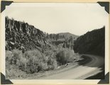
Lava Narrows. The Parunuweap has worn its way through basalt that filled its original canyon. Stream flows in groove at side of road, Kane County, UT, 1939
P0013 Herbert E. Gregory Photograph Collection
P0013n11_082_2663
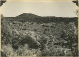
79
Corral Knoll volcanic cone, Kanab Valley, Kane County, Carmel limestone covered with lava (foreground), Cretaceous cliffs distance, Kane Co., UT. 1939
P0013 Herbert E. Gregory Photograph Collection
P0013n11_085_2666
80
View looking north down Workman Wash from divide between Little Creek and Short Creek. Basalt (left), terrace on Virgin member of Moenkopi (middle), upper Moenkopi (right). Moenkopi, Shinarump, Chinle, and Navajo (distance), Kane County, UT. 1939
P0013 Herbert E. Gregory Photograph Collection
P0013n11_086_2667
81
Vermillion Cliffs (Chinle and Navajo), north of edge of Uinkaret Plateau (foreground), mouth of Short Creek, Kane County, UT, 1939
P0013 Herbert E. Gregory Photograph Collection
P0013n11_088_2668
82
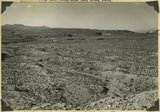
Big Plains, west dipping surface eroded on east dipping Chinle beds, now coated with coalescing fans. Little Creek Terrace in right background, Kane County, UT, 1939
P0013 Herbert E. Gregory Photograph Collection
P0013n11_088_2669
83
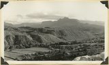
Kaibab Indian School near Moccasin looking northeast toward head of Two Mile Wash. Deep alluvial fill. Moenkopi capped by Shinarump (upper right), Chinle and Glen Canyon beds cliffs at upper left and middle distance (Lambs Point). Branch of Sevier fault crosses divide between Two Mile Wash and Sand Creek at base of Indian Point (left middle), Mohave County, AZ. 1939
P0013 Herbert E. Gregory Photograph Collection
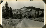
P0013n11_089_2670
84
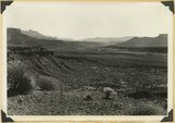
Kaibab Indian School looking north. Alluvial flats at head of Two Mile Wash. Branch of Sevier fault passes between Navajo (left distance) and Chinle-Navajo (middle distance), Mohave County, AZ. 1939
P0013 Herbert E. Gregory Photograph Collection
P0013n11_089_2671
85
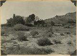
'Winsor Castle,' old stone fort at Pipe Springs, Mohave County, AZ. Sevier fault passes between Navajo sandstone." (upper right) and lower Moenkopi (foreground). 1939
P0013 Herbert E. Gregory Photograph Collection
P0013n11_090_2672
86
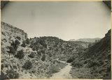
Alluvial terraces on Kanab Creek near mouth of Tiny Canyon, Kane County, UT. 1939. Excavated since 1882
P0013 Herbert E. Gregory Photograph Collection
P0013n11_090_2673
87
Fault in Jurassic formations 3 miles south of Mt. Carmel. Carmel limestone (left). Entrada and Carmel (right). Elkheart Cliffs (Navajo) (upper right). Kane County, UT, 1939
P0013 Herbert E. Gregory Photograph Collection
P0013n11_091_2674
88
General view of tilted Jurassic and Cretaceous beds looking northwest across Parunuweap Valley from base of Elkheart Cliffs southwest of Mt. Carmel; Valley of Muddy Brook (center) is at the contact of Winsor and Dakota formations (left) and Tropic shale (right), Kane County, UT, 1939
P0013 Herbert E. Gregory Photograph Collection
P0013n11_091_2675
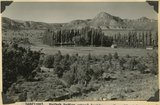
89
View looking south down Meadow Brook across Parunuweap Canyon to Block Mesas on Moccasin Terrace. Canyon cut in San Rafael strata. Pinions or Juniper. Kane County, UT. 1939
P0013 Herbert E. Gregory Photograph Collection
P0013n11_092_2676
90
Landslide (all the material in view) near mouth of Birch Creek, Zion Canyon. Covers upper part of and Springdale member (lower left) of the Chinle. Still active: Virgin river flows in groove at left of road, Washington County, UT, 1939
P0013 Herbert E. Gregory Photograph Collection
P0013n11_092_2677
91
Landslide, 1 mile south of Springdale, covers strata from base of Navajo (top left) to Shinarump. Springdale member of Chinle (left middle). Washington County, UT. 1939
P0013 Herbert E. Gregory Photograph Collection
P0013n11_093_2678
92
Landslide at mouth of Parunuweap (right center) extends from south of Springdale (foreground) across Parunuweap to base of Eagle Crags (top center). Involves entire Chinle formation. Washington County, UT. 1939
P0013 Herbert E. Gregory Photograph Collection
P0013n11_093_2679
93
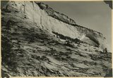
Navajo sandstone including Temple cap member (top). Shows typical recessed arch. Near east entrance, Zion Park, Kane County, UT. 1939
P0013 Herbert E. Gregory Photograph Collection
P0013n11_094_2680
94
View looking south-southwest across Timpoweap Canyon (center) to crest of Hurricane Cliffs (skyline). Floor chiefly the surface of east dipping beds of Timpoweap member of the Moenkopi. Lava capped mesas of upper Moenkopi (left distance). West of Virgin City. Washington County, UT. 1939
P0013 Herbert E. Gregory Photograph Collection
P0013n11_094_2681
95
View looking up Virgin River from a point 2 miles west of Virgin City, valley floor lower Moenkopi. Virgin member caps mesa(front ). Shinarump the terraces upstream. Navajo sandstone of South Mountain (right). Kinesawa Mountain (left) on skyline, Washington County, UT. 1939
P0013 Herbert E. Gregory Photograph Collection
P0013n11_095_2682
96
Hurricane Cliffs at Anderson Ranch. Kaibab and lower Moenkopi. Basalt (middle and upper right). Washington County, UT. 1939
P0013 Herbert E. Gregory Photograph Collection
P0013n11_095_2683
97
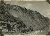
Wasatch formation near mouth of Red Canyon. Gray conglomerate unconformable over massive pink limestone. Above it friable limestone, volcanic ash and basalt, Garfield County, UT. 1939
P0013 Herbert E. Gregory Photograph Collection
P0013n11_097_2684
98
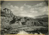
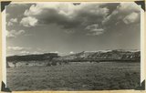
Sunset Cliffs as viewed east of Hatch. Sevier fault follows base of cliffs that include Cretaceous and Wasatch Pink Cliffs on skyline. Garfield County, UT, 1939
P0013 Herbert E. Gregory Photograph Collection
P0013n11_098_2685
99
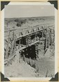
Bridge built by C.C.C. across recently eroded wash, near Pipe Springs. Mohave County, AZ. 1939
P0013 Herbert E. Gregory Photograph Collection
P0013n11_098_2686
100
Cedar Ridge. Cap of Shinarump conglomerate and upper Moenkopi extending south from Vermillion Cliffs onto Uinkaret Plateau west of Pipe Wash, Mohave County, AZ. 1939
P0013 Herbert E. Gregory Photograph Collection
P0013n11_099_2687
76
-
100
of
111
<
1
2
3
4
5
>