|
|
Title | Collection Number And Name | Photo Number |
| 51 |
 |
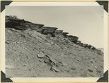
Joints in Navajo sandstone on Zion-Mt. Carmel road, Kane County, UT. 1939. | P0013 Herbert E. Gregory Photograph Collection | P0013n11_066_2636 |
| 52 |
 |
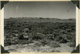
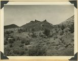
Northern edge Kanab Plateau. Village of Fredonia on surface eroded from lower Moenkopi beds and crossed by Kanab Creek. Buttes of Moenkopi capped by Shinarump (right), Coconino County, August, 1939 | P0013 Herbert E. Gregory Photograph Collection | P0013n11_067_2637 |
| 53 |
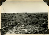 |
Surface of Uinkaret Plateau southwest of Cane Beds, Mohave County, AZ, Aug. 2, 1939 | P0013 Herbert E. Gregory Photograph Collection | P0013n11_067_2638 |
| 54 |
 |
Lake in Three Lakes Canyon fed from springs in Cane at the base of Navajo sandstone, Kane County, UT. 1939 | P0013 Herbert E. Gregory Photograph Collection | P0013n11_068_2639 |
| 55 |
 |
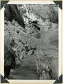
Eroded alluvial fill 60 feet thick in Kanab Creek. In 1884 stream ran at top of terrace, Kane Co., Utah, 1939 | P0013 Herbert E. Gregory Photograph Collection | P0013n11_068_2640 |
| 56 |
 |
Shinarump and Moenkopi beds disturbed by a local fault 3 miles north of Fredonia, Coconino County, AZ. 1939 | P0013 Herbert E. Gregory Photograph Collection | P0013n11_069_2641 |
| 57 |
 |
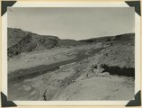
Erosion surface on lower Chinle beds at base of Vermillion Cliffs, traversed by Kanab Creek (left center), Kane County, UT. 1939 | P0013 Herbert E. Gregory Photograph Collection | P0013n11_069_2642 |
| 58 |
 |
View looking west toward buttes of Moenkopi capped by lava between Hurricane Cliffs and Workman Wash (foreground). Washington County, UT, 1939 | P0013 Herbert E. Gregory Photograph Collection | P0013n11_071_2643 |
| 59 |
 |
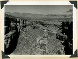
Mouth of Timpoweap Canyon of Virgin River looking east upstream. Kaibab and Moenkopi strata also basalt (upper left). Hurricane fault trends north-south in foreground. Washington County, UT, 1939 | P0013 Herbert E. Gregory Photograph Collection | P0013n11_071_2644 |
| 60 |
 |
Timpoweap Canyon at mouth of Alkali Wash (enters right center). Fossiliferous Permian at stream level. Triassic limestone outer walls. Intervening slope of conglomerate and calcareous sandstones, Washington County, UT. 1939 | P0013 Herbert E. Gregory Photograph Collection | P0013n11_072_2645 |
| 61 |
 |
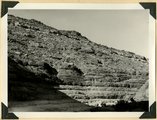
South wall of Timpoweap Canyon near mouth of Alkali Wash. Kaibab limestone (base), two beds of conglomerate separated by erosion surface, Moenkopi limestone top, Washington County, UT. 1939 | P0013 Herbert E. Gregory Photograph Collection | P0013n11_072_2646 |
| 62 |
 |
Permian-Triassic contact in Goulds Canyon (of little Creek). Kaibab (lowest ledge), conglomerate (second ledge), Moenkopi (third ledge and top). Washington County, UT. 1939 | P0013 Herbert E. Gregory Photograph Collection | P0013n11_073_2647 |
| 63 |
 |
Erosion surface produced by bevelling Chinle strata at the base of Vermillion Cliffs south of Cane Beds, Mohave County, AZ, 1939 | P0013 Herbert E. Gregory Photograph Collection | P0013n11_073_2648 |
| 64 |
 |
Moenkopi showing typical erosion of its shaly sandstones on Hurricane-Antelope Springs Road, Mohave County, AZ. 1939 | P0013 Herbert E. Gregory Photograph Collection | P0013n11_074_2649 |
| 65 |
 |
Divide dike basalt intruded in Moenkopi beds, head of Workman Wash, Washington County, UT, 1939 | P0013 Herbert E. Gregory Photograph Collection | P0013n11_074_2650 |
| 66 |
 |
Fault in lower Moenkopi shaly sandstone head of Rock Canyon (of Short Creek), Mohave County, AZ, 1939 | P0013 Herbert E. Gregory Photograph Collection | P0013n11_075_2651 |
| 67 |
 |
Folds in Moenkopi strata, Short Creek east of Rock Canyon, Mohave County, AZ, 1939 | P0013 Herbert E. Gregory Photograph Collection | P0013n11_075_2652 |
| 68 |
 |
South wall of Rock Canyon. Kaibab (on valley floor and up to first ledge), conglomerate, Moenkopi (upper part of slope and the cliffs), Mohave County, AZ, 1939 | P0013 Herbert E. Gregory Photograph Collection | P0013n11_076_2653 |
| 69 |
 |
Short Creek near the exit from its canyon, in Vermillion Cliffs. Alluvial terraces and broad channel made during past 50 years, Mohave County, AZ, 1939 | P0013 Herbert E. Gregory Photograph Collection | P0013n11_076_2654 |
| 70 |
 |
Cottonwood trees buried by sand dunes; trunks reexposed by recent excavations of alluvial valley fill, Short Creek, Mohave County, AZ, 1939 | P0013 Herbert E. Gregory Photograph Collection | P0013n11_077_2655 |
| 71 |
 |
Alluvial terraces made since 1900, Johnson Creek, Kane County, UT, 1939 | P0013 Herbert E. Gregory Photograph Collection | P0013n11_077_2656 |
| 72 |
 |
Spring (lower left) on local fault marked by displacement and slickensides (lower left), Johnson Canyon, Kane County, UT, 1939 | P0013 Herbert E. Gregory Photograph Collection | P0013n11_078_2657 |
| 73 |
 |
'The Granary': one of many natural cavities in Wingate sandstone utilized for storage, Johnson Canyon, Kane County, UT, 1939 | P0013 Herbert E. Gregory Photograph Collection | P0013n11_078_2658 |
| 74 |
 |
Entrada, Curtis, and Winsor formation overlain by Dakota (extreme top), Alton-Skutumpah road, Kane County, UT, 1939 | P0013 Herbert E. Gregory Photograph Collection | P0013n11_079_2659 |
| 75 |
 |
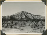
Lava flow from Bald Knoll Crater (foreground), Upper Jurassic (lower cliffs), and tertiary (upper cliffs), Kane County, UT, 1939 | P0013 Herbert E. Gregory Photograph Collection | P0013n11_079_2660 |