Home
Browse
Ask Us
Chat
Harmful Language Statement
Log in
Photo Archives
Advanced Search
About
Over 70,000 photos covering a variety of topics from Marriott Library Special Collections
Year
1938
1939
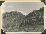
1940
TO
1938
1939
1940
Type
Image
111
Format
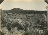
image/jpeg
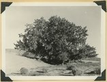
111
Collection
Photo Archives
111
Filters:
Collection Name:
"Herbert E. Gregory"
Date:
"1939"
Format:
"image/jpeg"
1
-
25
of
111
<
1
2
3
4
5
>
Gallery view
Number of results to display per page
10
25
50
100
200
Sort by Relevance
Sort by Title A-Z
Sort by Title Z-A
Sort by Date Ascending
Sort by Date Descending
Sort by Last Modified Ascending
Sort by Last Modified Descending
Title
Date
Type
1
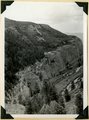
'Elephant feet'. Wingate sandstone, Kayenta above. Three Lakes Canyon, Kane County, UT, 1939
1939
Image
2
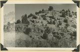
'The Granary': one of many natural cavities in Wingate sandstone utilized for storage, Johnson Canyon, Kane County, UT, 1939
1939
Image
3
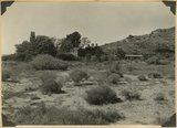
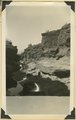
'Winsor Castle', old fort at Pipe Springs, looking south over Unikaret Plateau, Kanab Canyon upper right
1939
Image
4
'Winsor Castle,' old stone fort at Pipe Springs, Mohave County, AZ. Sevier fault passes between Navajo sandstone." (upper right) and lower Moenkopi (foreground). 1939
1939
Image
5
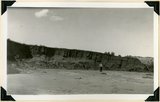
Alluvial terraces made since 1900, Johnson Creek, Kane County, UT, 1939
1939
Image
6
Alluvial terraces on Kanab Creek near mouth of Tiny Canyon, Kane County, UT. 1939. Excavated since 1882
1939
Image
7
Ancient gravels, (left center) form terrace both sides of Virgin River between Rockville and Grafton. Rest unconformably on middle Moenkopi beds, upper Moenkopi, Shinarump, Chinle, and Navajo above. Washington County, UT, 1939
1939
Image
8
Ancient talus (right foreground) and talus now forming at base of Kinesava mountain, Zion National Park, Washington County, UT, 1939
1939
Image
9
Base of Straight Cliffs formation (Cretaceous) at Orderville. Tropic shale forms slope at bottom. Kane County, UT, 1939
1939
Image
10
Bed of little Creek, sunk 10 feet to 40 feet into alluvium since 1890, Kane County, UT, 1939
1939
Image
11
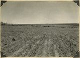
Big Plains, west dipping surface eroded on east dipping Chinle beds, now coated with coalescing fans. Little Creek Terrace in right background, Kane County, UT, 1939
1939
Image
12
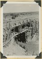
Bridge built by C.C.C. across recently eroded wash, near Pipe Springs. Mohave County, AZ. 1939
1939
Image
13
Camp Creek near its mouth in Hurricane Cliffs. Navajo sandstone overlain by Carmel, Entrada, Curtis and Winsor. Pine Valley mountains (right distance), Washington County, UT, 1939
1939
Image
14
Carmel (bottom), Entrada (slope), Curtis (cliff of gypsum) and Winsor formation (top slope), Meadow Brook Canyon, Kane County, UT, 1939
1939
Image
15
Carmel formation (cliff) at head of Flume Canyon upthrow (east) side of Sevier fault which trends northeasterly. Cretaceous formations (background) at level of Jurassic. Kane County, UT. 1939
1939
Image
16
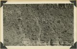
Carmel formation in branch of Flume Canyon. About half of total shown. Kane County, UT. 1939
1939
Image
17
Carmel formation in Mineral Gulch. Typical arrangement of shaly and massive beds, Kane County, UT. 1939
1939
Image
18
Cedar Ridge. Cap of Shinarump conglomerate and upper Moenkopi extending south from Vermillion Cliffs onto Uinkaret Plateau west of Pipe Wash, Mohave County, AZ. 1939
1939
Image
19
Consolidated river gravel (Wisconsin age?) overlying eroded Entrada(?) 300 feet above Paria River 2 miles south of Cannonville, Kane County, UT, 1939
1939
Image
20
Contact of fossiliferous Kaibab (base) and fossiliferous Moenkopi (top), Isom Wash, Washington Co., UT, 1939. Exact contact not placed
1939
Image
21
Contact of old and recent basalt flows near head of Gould Canyon, Washington County, UT, 1939
1939
Image
22
Corral Knoll volcanic cone, Kanab Valley, Kane County, Carmel limestone covered with lava (foreground), Cretaceous cliffs distance, Kane Co., UT. 1939
1939
Image
23
Cottonwood trees buried by sand dunes; trunks reexposed by recent excavations of alluvial valley fill, Short Creek, Mohave County, AZ, 1939
1939
Image
24
Cougar Mountain fault. Springdale member of Chinle (lower left) abutting against base of Navajo (lower right), Washington County, UT, 1939
1939
Image
25
Cowboy Butte 2 miles north of Fredonia. Moenkopi (Shnabkaib member at base) and Shinarump, Coconino County, AZ. 1939
1939
Image
1
-
25
of
111
<
1
2
3
4
5
>