|
|
Title | Collection Number And Name | Photo Number |
| 26 |
 |
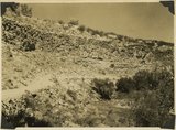
Lava flow over gravel wash. South of Toquerville, Utah, along main road from Zion Canyon to Anderson's Ranch. | P0013 Herbert E. Gregory Photograph Collection | P0013n10_072_2208 |
| 27 |
 |
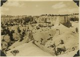
View southwest toward the rim of Bryce Canyon from the north side of lower canyon near the Fairy Temple trail. | P0013 Herbert E. Gregory Photograph Collection | P0013n10_074_2209 |
| 28 |
 |
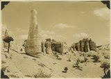
View east toward Seal Castle and Fairy Temple. "Lot's wife" in the foreground. | P0013 Herbert E. Gregory Photograph Collection | P0013n10_075_2210 |
| 29 |
 |
Fault in gulch along road 1/2 mile northwest Mt. Carmel Junction, throw 120 feet. 1936. | P0013 Herbert E. Gregory Photograph Collection | P0013n10_133_2314 |
| 30 |
 |
Fault in gulch, Mt. Carmel Junc. | P0013 Herbert E. Gregory Photograph Collection | P0013n10_133_2314 |
| 31 |
 |
View looking north across Virgin River at Rockville. Foreground, Moenkopi capped by Shinarump; middle distance, Chinle; distance, Navajo forming Mount Kinesava. Washington County, Utah, 1936. | P0013 Herbert E. Gregory Photograph Collection | P0013n10_133_2315 |
| 32 |
 |
Moenkopi capped by Shinarump. Coalpits volcano in distance. Virgin River in foreground. Rockville, Washington County, Utah, 1936. | P0013 Herbert E. Gregory Photograph Collection | P0013n10_134_2316 |
| 33 |
 |
Top Vermilion Cliffs east of Kanab, Navajo, Kayenta, Wingate, 1936. | P0013 Herbert E. Gregory Photograph Collection | P0013n10_134_2317 |
| 34 |
 |
Vermillion Cliff, Kanab | P0013 Herbert E. Gregory Photograph Collection | P0013n10_134_2317 |
| 35 |
 |
Cutting of alluvial fill, Kanab Canyon, above mouth of Caves Lake Canyon, Wingate, Kayenta. Navajo at right, Kane County, Utah, 1936. | P0013 Herbert E. Gregory Photograph Collection | P0013n10_135_2318 |
| 36 |
 |
Top of Kanab Canyon | P0013 Herbert E. Gregory Photograph Collection | P0013n10_135_2319 |
| 37 |
 |
Top of wall of Kanab Canyon below mouth of Cave Lake Canyon. Navajo, Kayenta, Wingate, 1936. | P0013 Herbert E. Gregory Photograph Collection | P0013n10_135_2319 |
| 38 |
 |
Wingate sandstone. Three Lakes Canyon, Kane County, Utah, 1936. | P0013 Herbert E. Gregory Photograph Collection | P0013n10_136_2320 |
| 39 |
 |
Wingate sandstone overlaid by Kayenta formation, Cave Lakes Canyon, Kane County, Utah, 1936. | P0013 Herbert E. Gregory Photograph Collection | P0013n10_136_2321 |
| 40 |
 |
"Marls" in Chinle formation, Springdale, Washington County, Utah, 1936. | P0013 Herbert E. Gregory Photograph Collection | P0013n10_137_2322 |
| 41 |
 |
"Marls" in Chinle formation. Above them the Springdale member of Chinle, Springdale, Washington County, Utah, 1936. | P0013 Herbert E. Gregory Photograph Collection | P0013n10_138_2323 |
| 42 |
 |
Upper part of Chinle formation. "Marls" in foreground. Near Kanab, Kane County, Utah, 1936. | P0013 Herbert E. Gregory Photograph Collection | P0013n10_138_2324 |
| 43 |
 |
Mesas of Moenkopi capped by Shinarump. Virgin River looking downstream at Rockville, Washington County, Utah, 1936. | P0013 Herbert E. Gregory Photograph Collection | P0013n10_139_2325 |
| 44 |
 |
Looking north along Sevier fault at Orderville. Right, Carmel and Navajo; left, Straight Cliffs formation (Crfetaceous). Kane County, Utah, 1936. | P0013 Herbert E. Gregory Photograph Collection | P0013n10_139_2326 |
| 45 |
 |
Straight Cliffs, Tropic shale and Wahweap sandstones (Cretaceous), head of La Verkin Creek, Washington County, Utah, 1936. | P0013 Herbert E. Gregory Photograph Collection | P0013n10_140_2327 |
| 46 |
 |
Carmel limestone, Mt. Carmel Junction, 1936. | P0013 Herbert E. Gregory Photograph Collection | P0013n10_140_2328 |
| 47 |
 |
Mt. Carmel Junc. | P0013 Herbert E. Gregory Photograph Collection | P0013n10_140_2328 |
| 48 |
 |
Near Rockville | P0013 Herbert E. Gregory Photograph Collection | P0013n10_140_2329 |
| 49 |
 |
Upper Moenkopi capped by Shinarump near Rockville, 1936. | P0013 Herbert E. Gregory Photograph Collection | P0013n10_140_2329 |
| 50 |
 |
Chinle "marls" Springdale, 1936. | P0013 Herbert E. Gregory Photograph Collection | P0013n10_141_2330 |