|
|
Title | Date | Type |
| 1 |
 |
Abandoned Logan, San Juan River, 10 miles above mouth | 1920; 1921; 1922; 1923; 1924; 1925; 1926; 1927; 1928; 1929; 1930 | Image |
| 2 |
 |
Alluvial fill exposed by recent erosion. Comb Wash, San Juan County, Utah, 1929. | 1929 | Image |
| 3 |
 |
Arch Canyon, Coconino over Supai | 1920; 1921; 1922; 1923; 1924; 1925; 1926; 1927; 1928; 1929; 1930 | Image |
| 4 |
 |
Beds lying with unconformity immediately on top of massive Bluff sandstone near mouth of Recapture Creek, San Juan County, Utah, 1929. | 1929 | Image |
| 5 |
 |
Bluff sandstone and underlying beds at head of Butler Wash, San Juan County, Utah, 1929. | 1929 | Image |
| 6 |
 |
Bluff sandstone and underlying beds at Reservoir, 1 mile west of Bluff, San Juan County, Utah, 1929. | 1929 | Image |
| 7 |
 |
Bluff sandstone, San Juan Co., Ut., 1929 | 1929 | Image |
| 8 |
 |
Bluffs at Bluff, UT | 1920; 1921; 1922; 1923; 1924; 1925; 1926; 1927; 1928; 1929; 1930 | Image |
| 9 |
 |
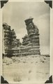
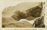
Cathedral Arch I. Arch Canyon | 1920; 1921; 1922; 1923; 1924; 1925; 1926; 1927; 1928; 1929; 1930 | Image |
| 10 |
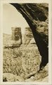 |
Cathedral Arch I. Arch Canyon | 1920; 1921; 1922; 1923; 1924; 1925; 1926; 1927; 1928; 1929; 1930 | Image |
| 11 |
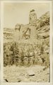 |
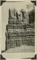
Cathedral Arch II, Arch Canyon, Coconino over Supai | 1920; 1921; 1922; 1923; 1924; 1925; 1926; 1927; 1928; 1929; 1930 | Image |
| 12 |
 |
Cathedral Arch II, Arch Canyon, Coconino over Supai | 1920; 1921; 1922; 1923; 1924; 1925; 1926; 1927; 1928; 1929; 1930 | Image |
| 13 |
 |
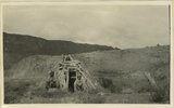
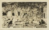
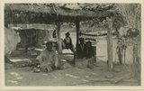
Cliff house north side of San Juan near Bluff | 1920; 1921; 1922; 1923; 1924; 1925; 1926; 1927; 1928; 1929; 1930 | Image |
| 14 |
 |
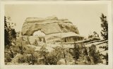
Cliff House, Fable Valley (Fred Lowrey, Honolulu) | 1920; 1921; 1922; 1923; 1924; 1925; 1926; 1927; 1928; 1929; 1930 | Image |
| 15 |
 |
Cliff House, Fable Valley (Fred Lowrey, Honolulu) | 1920; 1921; 1922; 1923; 1924; 1925; 1926; 1927; 1928; 1929; 1930 | Image |
| 16 |
 |
Cliff House, Fable Valley (Fred Lowrey, Honolulu) | 1920; 1921; 1922; 1923; 1924; 1925; 1926; 1927; 1928; 1929; 1930 | Image |
| 17 |
 |
Coconino marls overlying Supai red beds. West side of Comb Wash near mouth. San Juan County, Utah, 1929. | 1929 | Image |
| 18 |
 |
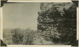
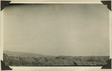
Comb Ridge, San Juan Co.,, Ut. | 1929 | Image |
| 19 |
 |
Comb Ridge, San Juan Co.,, Ut., 1929 | 1929 | Image |
| 20 |
 |
Gravel topped terrace over lower Morrison strata, 2± miles below Aneth, San Juan County, Utah, 1929. | 1929 | Image |
| 21 |
 |
Inscriptions right bank, Glen Canyon below Smith's Fork | 1920; 1921; 1922; 1923; 1924; 1925; 1926; 1927; 1928; 1929; 1930 | Image |
| 22 |
 |
Jim Joe's House, U.S.G.S. = U.S. Geological Survey, Miser 654 (Robert T. Allen), near mouth of Butler Wash | 1920; 1921; 1922; 1923; 1924; 1925; 1926; 1927; 1928; 1929; 1930 | Image |
| 23 |
 |
Keystone Arch, Arch Canyon, Coconino sandstone | 1920; 1921; 1922; 1923; 1924; 1925; 1926; 1927; 1928; 1929; 1930 | Image |
| 24 |
 |
Keystone Arch, Arch Canyon, Coconino sandstone | 1920; 1921; 1922; 1923; 1924; 1925; 1926; 1927; 1928; 1929; 1930 | Image |
| 25 |
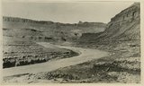 |
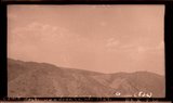
Looking down San Juan River, 3/4 mile below Makai Creek | 1920; 1921; 1922; 1923; 1924; 1925; 1926; 1927; 1928; 1929; 1930 | Image |