Home
Browse
Ask Us
Chat
Harmful Language Statement
Log in
Photo Archives
Advanced Search
About
Over 70,000 photos covering a variety of topics from Marriott Library Special Collections
Year
1920
1921
1922
1923
1924
1925
1926
1927
1928
1929
1930
TO
1920
1921
1922
1923
1924
1925
1926
1927
1928
1929
1930
Type
Image
63
Format
image/jpeg
63
Collection
Photo Archives
63
Filters:
Collection Name:
"Herbert E. Gregory"
Date:
"1929"
Format:
"image/jpeg"
Setname:
!(ir* OR ehsl*)
51
-
75
of
63
<
1
2
3
>
Gallery view
Number of results to display per page
10
25
50
100
200
Sort by Relevance
Sort by Title A-Z
Sort by Title Z-A
Sort by Date Ascending
Sort by Date Descending
Sort by Last Modified Ascending
Sort by Last Modified Descending
Title
Date
Type
51
Survey headquarters, Blanding, UT. Lowrey
1920; 1921; 1922; 1923; 1924; 1925; 1926; 1927; 1928; 1929; 1930
Image
52
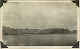
Tabernacle loop, San Juan River
1920; 1921; 1922; 1923; 1924; 1925; 1926; 1927; 1928; 1929; 1930
Image
53
Top of Elk Ridge. View looking northeast from Bears Ears, San Juan County, Utah, 1929.
1929
Image
54
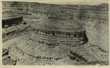
Upper bed of "Bluff sandstone" with shales between it and lower sandstone bed (concealed). North bank San Juan River 5+ miles above mouth of Recapture Creek, San Juan County, Utah, 1929.
1929
Image
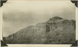
55
Upper part of Morrison formation. East side of Recapture Creek near its mouth. Dakota at the top. San Juan County, Utah, 1929.]
1929
Image
56
View from top of Augusta Bridge, White Canyon, Coconino sandstone
1920; 1921; 1922; 1923; 1924; 1925; 1926; 1927; 1928; 1929; 1930
Image
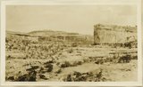
57
View looking north from mouth of Comb Wash. Left: Coconino (light bands) over Supai. Right Chinle Wingate Navajo forming Comb Ridge. San Juan County, Utah, 1929.
1929
Image
58
View looking north up Butler Wash. Left: Navajo sandstone forming back slope of Comb Ridge. Right: Bluff sandstone in middle distance capping red sandstones and shales. San Juan County, Utah, 1929.
1929
Image
59
View looking south across San Juan River at mouth of Comb Wash showing platform out across tilted Chenle, Moenkope and DeChelly strata. Mule Ear peak in right distance. San Juan County, Utah, 1929.
1929
Image
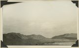
60
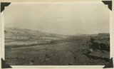
View looking south across San Juan Valley at Aneth. Morrison strata, distant plateau capped by Dakota. San Juan County, Utah, 1929.
1929
Image
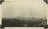
61
View looking west from south end of Elk Ridge across Armstrong Canyon. Moenkopi beds in right foreground, Coconino in middle distance, mesas of Navajo beyond. San Juan County, Utah, 1929.
1929
Image
62
View of East Bears Ear looking east from top of Elk Ridge. Chinle strata capped by Wingate. San Juan County, Utah, 1929.
1929
Image
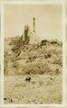
63
The Watchman Arch Canyon, Coconino over Supai
1920; 1921; 1922; 1923; 1924; 1925; 1926; 1927; 1928; 1929; 1930
Image
51
-
75
of
63
<
1
2
3
>