Home
Browse
Ask Us
Chat
Harmful Language Statement
Log in
Photo Archives
Advanced Search
About
Over 70,000 photos covering a variety of topics from Marriott Library Special Collections
Year
1920
1921
1922
1923
1924
1925
1926
1927
1928
1929
1930
TO
1920
1921
1922
1923
1924
1925
1926
1927
1928
1929
1930
Type
Image
63
Format
image/jpeg
63
Collection
Photo Archives
63
Filters:
Collection Name:
"Herbert E. Gregory"
Date:
"1929"
Format:
"image/jpeg"
Setname:
!(ir* OR ehsl*)
26
-
50
of
63
<
1
2
3
>
Gallery view
Number of results to display per page
10
25
50
100
200
Sort by Relevance
Sort by Title A-Z
Sort by Title Z-A
Sort by Date Ascending
Sort by Date Descending
Sort by Last Modified Ascending
Sort by Last Modified Descending
Title
Date
Type
26
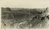
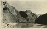
Looking down San Juan River, near Spencer Camp, U.S.G.S. Miser 607, Robert T. Allen
1920; 1921; 1922; 1923; 1924; 1925; 1926; 1927; 1928; 1929; 1930
Image
27
Looking into head of Arch Canyon from Elk ridge. Coconino, Moenkopi, Shinarump
1920; 1921; 1922; 1923; 1924; 1925; 1926; 1927; 1928; 1929; 1930
Image
28
Looking up San Juan River 6 miles below Spencer Camp, U.S.G.S. Miser 610, Robert T. Allen
1920; 1921; 1922; 1923; 1924; 1925; 1926; 1927; 1928; 1929; 1930
Image
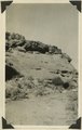
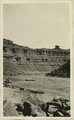
29
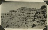
Massive sandstone in Morrison stratigraphic portion of "Bluff sandstone" changes to shale 1/4 mile along strike 3± miles above mouth of Montezuma Creek, San Juan County, Utah, 1929.
1929
Image
30
Montezuma Creek, San Juan County, UT
1929
Image
31
Monuments in Arch Canyon, Coconino over Supai
1920; 1921; 1922; 1923; 1924; 1925; 1926; 1927; 1928; 1929; 1930
Image
32
Morrison strata between Aneth and mouth of Montezuma Creek, San Juan County, Utah, 1929.
1929
Image
33
Navajo (?) sandstone and overlying beds in canyon 12± miles east of Utah Colorado line, 1929
1929
Image
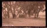
34
Partly buried cottonwoods on floor plain of San Juan River 5+ miles above mouth of Recapture Creek, San Juan County, Utah, 1929.
1929
Image
35
Red House in Red Canyon, U. S. G. S., Miser, 448
1920; 1921; 1922; 1923; 1924; 1925; 1926; 1927; 1928; 1929; 1930
Image
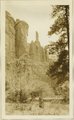
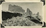
36
Ruins in Hovenweep National Monument resting on ruin of canyon tributary to McElmo. Country rock is Dakota sandstone, San Juan County, Utah, 1929.
1929
Image
37
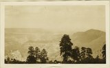
Same as 1819 [View looking south across San Juan Valley at Aneth. Morrison strata, distant plateau capped by Dakota. San Juan County, Utah, 1929]
1929
Image
38
Same as 816 showing also San Juan River [Massive sandstone in Morrison stratigraphic portion of "Bluff sandstone" ... above mouth of Montezuma Creek]
1929
Image
39
Same as 821 [Navajo (?) sandstone and overlying beds in canyon 12± miles east of Utah Colorado line, 1929]
1929
Image
40
Same as 828 [Upper bed of "Bluff sandstone" with shales between it and lower sandstone bed (concealed). North bank San Juan River 5+ miles above mouth of Recapture Creek, San Juan County, Utah, 1929]
1929
Image
41
Same as 828 [Upper bed of "Bluff sandstone" with shales between it and lower sandstone bed (concealed). North bank San Juan River 5+ miles above mouth of Recapture Creek, San Juan County, Utah, 1929]. Top of lower bed of Bluff sandstone in left foreground.
1929
Image
42
Same as 838 [View looking west from south end of Elk Ridge across Armstrong Canyon. Moenkopi beds in right foreground, Coconino in middle distance, mesas of Navajo beyond. San Juan County, Utah, 1929.]
1929
Image
43
San Juan Canyon at mouth of Grand Gulch. Goodridge, Moonlight, and Hermit formations, Miser
1920; 1921; 1922; 1923; 1924; 1925; 1926; 1927; 1928; 1929; 1930
Image
44
San Juan Canyon between Honoker trail and Johns Canyon, Goodridge formation, Miser
1920; 1921; 1922; 1923; 1924; 1925; 1926; 1927; 1928; 1929; 1930
Image
45
San Juan River between narrows and mouth of Chinle, U. S. G. S., Miser, 418
1920; 1921; 1922; 1923; 1924; 1925; 1926; 1927; 1928; 1929; 1930
Image
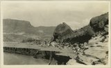
46
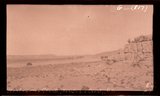
San Juan River plain, San Juan Co., Ut.
1929
Image
47
San Juan River, 1929
1929
Image
48
San Juan River, Mule Ear Pk., San Juan Co., Ut.
1929
Image
49
Sand Flat Skewer Camp, San Juan River
1920; 1921; 1922; 1923; 1924; 1925; 1926; 1927; 1928; 1929; 1930
Image
50
Shales between upper and lower beds of "Bluff sandstone" 3± miles east of mouth of Recapture Creek.
1929
Image
26
-
50
of
63
<
1
2
3
>