|
|
Title | Collection Number And Name | Photo Number |
| 26 |
 |
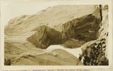
Cathedral Arch I. Arch Canyon | P0013 Herbert E. Gregory Photograph Collection | P0013n09_169_2040 |
| 27 |
 |
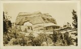
Keystone Arch, Arch Canyon, Coconino sandstone | P0013 Herbert E. Gregory Photograph Collection | P0013n09_169_2041 |
| 28 |
 |
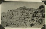
Keystone Arch, Arch Canyon, Coconino sandstone | P0013 Herbert E. Gregory Photograph Collection | P0013n09_170_2042 |
| 29 |
 |
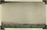
Bluffs at Bluff, UT | P0013 Herbert E. Gregory Photograph Collection | P0013n09_170_2043 |
| 30 |
 |
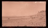
Gravel topped terrace over lower Morrison strata, 2± miles below Aneth, San Juan County, Utah, 1929. | P0013 Herbert E. Gregory Photograph Collection | P0013n10_006_2099 |
| 31 |
 |
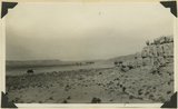
Massive sandstone in Morrison stratigraphic portion of "Bluff sandstone" changes to shale 1/4 mile along strike 3± miles above mouth of Montezuma Creek, San Juan County, Utah, 1929. | P0013 Herbert E. Gregory Photograph Collection | P0013n10_006_2100 |
| 32 |
 |
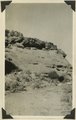
Montezuma Creek, San Juan County, UT | P0013 Herbert E. Gregory Photograph Collection | P0013n10_007_2101 |
| 33 |
 |
Same as 816 showing also San Juan River [Massive sandstone in Morrison stratigraphic portion of "Bluff sandstone" ... above mouth of Montezuma Creek] | P0013 Herbert E. Gregory Photograph Collection | P0013n10_007_2101 |
| 34 |
 |
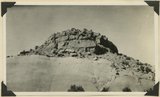
Morrison strata between Aneth and mouth of Montezuma Creek, San Juan County, Utah, 1929. | P0013 Herbert E. Gregory Photograph Collection | P0013n10_007_2102 |
| 35 |
 |
View looking south across San Juan Valley at Aneth. Morrison strata, distant plateau capped by Dakota. San Juan County, Utah, 1929. | P0013 Herbert E. Gregory Photograph Collection | P0013n10_008_2103 |
| 36 |
 |
Same as 1819 [View looking south across San Juan Valley at Aneth. Morrison strata, distant plateau capped by Dakota. San Juan County, Utah, 1929] | P0013 Herbert E. Gregory Photograph Collection | P0013n10_008_2104 |
| 37 |
 |
Navajo (?) sandstone and overlying beds in canyon 12± miles east of Utah Colorado line, 1929 | P0013 Herbert E. Gregory Photograph Collection | P0013n10_009_2105 |
| 38 |
 |
Same as 821 [Navajo (?) sandstone and overlying beds in canyon 12± miles east of Utah Colorado line, 1929] | P0013 Herbert E. Gregory Photograph Collection | P0013n10_009_2106 |
| 39 |
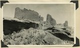 |
Ruins in Hovenweep National Monument resting on ruin of canyon tributary to McElmo. Country rock is Dakota sandstone, San Juan County, Utah, 1929. | P0013 Herbert E. Gregory Photograph Collection | P0013n10_009_2107 |
| 40 |
 |
San Juan River, Mule Ear Pk., San Juan Co., Ut. | P0013 Herbert E. Gregory Photograph Collection | P0013n10_010_2108 |
| 41 |
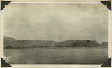 |
View looking south across San Juan River at mouth of Comb Wash showing platform out across tilted Chenle, Moenkope and DeChelly strata. Mule Ear peak in right distance. San Juan County, Utah, 1929. | P0013 Herbert E. Gregory Photograph Collection | P0013n10_010_2108 |
| 42 |
 |
Comb Ridge, San Juan Co.,, Ut. | P0013 Herbert E. Gregory Photograph Collection | P0013n10_010_2109 |
| 43 |
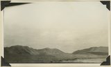 |
View looking north from mouth of Comb Wash. Left: Coconino (light bands) over Supai. Right Chinle Wingate Navajo forming Comb Ridge. San Juan County, Utah, 1929. | P0013 Herbert E. Gregory Photograph Collection | P0013n10_010_2109 |
| 44 |
 |
Coconino marls overlying Supai red beds. West side of Comb Wash near mouth. San Juan County, Utah, 1929. | P0013 Herbert E. Gregory Photograph Collection | P0013n10_011_2110 |
| 45 |
 |
Comb Ridge, San Juan Co.,, Ut., 1929 | P0013 Herbert E. Gregory Photograph Collection | P0013n10_011_2110 |
| 46 |
 |
Partly buried cottonwoods on floor plain of San Juan River 5+ miles above mouth of Recapture Creek, San Juan County, Utah, 1929. | P0013 Herbert E. Gregory Photograph Collection | P0013n10_011_2111 |
| 47 |
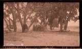 |
San Juan River plain, San Juan Co., Ut. | P0013 Herbert E. Gregory Photograph Collection | P0013n10_011_2111 |
| 48 |
 |
Same as 828 [Upper bed of "Bluff sandstone" with shales between it and lower sandstone bed (concealed). North bank San Juan River 5+ miles above mouth of Recapture Creek, San Juan County, Utah, 1929] | P0013 Herbert E. Gregory Photograph Collection | P0013n10_012_2112 |
| 49 |
 |
San Juan River, 1929 | P0013 Herbert E. Gregory Photograph Collection | P0013n10_012_2112 |
| 50 |
 |
Upper bed of "Bluff sandstone" with shales between it and lower sandstone bed (concealed). North bank San Juan River 5+ miles above mouth of Recapture Creek, San Juan County, Utah, 1929. | P0013 Herbert E. Gregory Photograph Collection | P0013n10_012_2113 |