Home
Browse
Ask Us
Chat
Harmful Language Statement
Log in
Photo Archives
Advanced Search
About
Over 70,000 photos covering a variety of topics from Marriott Library Special Collections
Year
1875
1876
1877
1878
1879
1880
1881
1882
1883
1884
1885
1886
1887
1888
1889
1890
1891
1892
1893
1894
1895
1896
1897
1898
1899
1900
1901
1902
1903
1904
1905
1906
1907
1908
1909
1910
1911
1912
1913
1914
1915
1916
1917
1918
1919
1920
1921
1922
1923
1924
1925
1926
1927
1928
1929
1930
1931
1932
1933
1934
1935
1936
1937
1938
TO
1875
1876
1877
1878
1879
1880
1881
1882
1883
1884
1885
1886
1887
1888
1889
1890
1891
1892
1893
1894
1895
1896
1897
1898
1899
1900
1901
1902
1903
1904
1905
1906
1907
1908
1909
1910
1911
1912
1913
1914
1915
1916
1917
1918
1919
1920
1921
1922
1923
1924
1925
1926
1927
1928
1929
1930
1931
1932
1933
1934
1935
1936
1937
1938
Type
Image
93
Format
image/jpeg
90
application/pdf
3
Collection
Photo Archives
93
Filters:
Collection Name:
"Herbert E. Gregory"
Date:
"1924"
76
-
100
of
93
<
1
2
3
4
>
Gallery view
Number of results to display per page
10
25
50
100
200
Sort by Relevance
Sort by Title A-Z
Sort by Title Z-A
Sort by Date Ascending
Sort by Date Descending
Sort by Last Modified Ascending
Sort by Last Modified Descending
Title
Date
Type
76
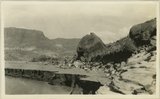
Sand Flat Skewer Camp, San Juan River
1920; 1921; 1922; 1923; 1924; 1925; 1926; 1927; 1928; 1929; 1930
Image
77
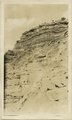
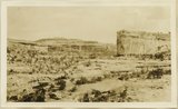
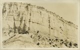
Sandstone and shale, 'Marine Jurassic'. Wall of Paria River, 3 miles below Cannonville
1924
Image
78
Searles Lake, California. Columns of tufa south end of Searles Lake
1924
Image
79
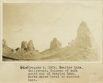
Searles Lake, California. Columns of tufa south end of Searles Lake. Marks water level of ancient lake
1924
Image
80
Silurian Dry Lake and north face of the Avanatz Mountains from mine in Silurian Mountains east of Riggs
1924
Image
81
South end of Silurian Mountains from a point about a mile east of Riggs
1924
Image
82
Survey headquarters, Blanding, UT. Lowrey
1920; 1921; 1922; 1923; 1924; 1925; 1926; 1927; 1928; 1929; 1930
Image
83
Tabernacle loop, San Juan River
1920; 1921; 1922; 1923; 1924; 1925; 1926; 1927; 1928; 1929; 1930
Image
84
Vegetation (pinion, cedar) in shales just above Navajo sandstone, Cottonwood Wash, Kane County, UT, 1924
1924
Image
85
View across old outflow channel of Silver Lake
1924
Image
86
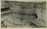
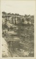
View from top of Augusta Bridge, White Canyon, Coconino sandstone
1920; 1921; 1922; 1923; 1924; 1925; 1926; 1927; 1928; 1929; 1930
Image
87
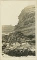
View northward across valley of Wingate Wash from Hidden Spring, Paramint Mountains in background. Low hills upturned Tertiary Lake beds in foreground contain the Epsomite deposits
1924
Image
88
View of Allen Canyon country. Winter and summer Hogan, Piute Indians
1924
Image
89
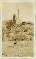
Wall of White Canyon, M. L. Gould, 1924,
1924
Image
90
The Watchman Arch Canyon, Coconino over Supai
1920; 1921; 1922; 1923; 1924; 1925; 1926; 1927; 1928; 1929; 1930
Image
91
Waterfall after showers, White Canyon
1924
Image
92
Wingate Pass from Panamint Valley
1924
Image
93
Yellow-red sandstone above gypsiferous shales, Waweap formation 3 miles SE of Cannonville. Equivalent of beds shown in photograph 1728. Garfield County, UT 1924
1924
Image
76
-
100
of
93
<
1
2
3
4
>