Home
Browse
Ask Us
Chat
Harmful Language Statement
Log in
Photo Archives
Advanced Search
About
Over 70,000 photos covering a variety of topics from Marriott Library Special Collections
Year
1875
1876
1877
1878
1879
1880
1881
1882
1883
1884
1885
1886
1887
1888
1889
1890
1891
1892
1893
1894
1895
1896
1897
1898
1899
1900
1901
1902
1903
1904
1905
1906
1907
1908
1909
1910
1911
1912
1913
1914
1915
1916
1917
1918
1919
1920
1921
1922
1923
1924
1925
1926
1927
1928
1929
1930
1931
1932
1933
1934
1935
1936
1937
1938
TO
1875
1876
1877
1878
1879
1880
1881
1882
1883
1884
1885
1886
1887
1888
1889
1890
1891
1892
1893
1894
1895
1896
1897
1898
1899
1900
1901
1902
1903
1904
1905
1906
1907
1908
1909
1910
1911
1912
1913
1914
1915
1916
1917
1918
1919
1920
1921
1922
1923
1924
1925
1926
1927
1928
1929
1930
1931
1932
1933
1934
1935
1936
1937
1938
Type
Image
93
Format
image/jpeg
90
application/pdf
3
Collection
Photo Archives
93
Filters:
Collection Name:
"Herbert E. Gregory"
Date:
"1924"
26
-
50
of
93
<
1
2
3
4
>
Gallery view
Number of results to display per page
10
25
50
100
200
Sort by Relevance
Sort by Title A-Z
Sort by Title Z-A
Sort by Date Ascending
Sort by Date Descending
Sort by Last Modified Ascending
Sort by Last Modified Descending
Title
Date
Type
26
Edwin Bridge, White Canyon (Prof. L.M. Gould, University of Michigan, 1924.)
1924
Image
27
Epsomite deposits associated with Tertiary lake beds 4 miles south of Wingate Wash
1924
Image
28
Epsomite deposits in tertiary lake Beds 4 miles south of Wingate Wash
1924
Image
29
Fault between gypsum-bearing beds and granite in San Andreas Rift Zone on east side of Little Rock Creek, Elizabeth Lake Quadrangle. Fault plane nearly vertical
1924
Image
30
Folded gypsum-bearing beds in east bank of Little Rock Creek near San Andreas Rift, Elizabeth Lake Quadrangle
1924
Image
31
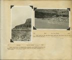
General view upper two thirds Waweap beds 1 mile southwest of Cannonville, Garfield County, UT 1924
1924
Image
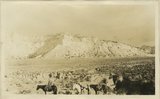
32
General view walls of Dry Valley, Kane County, UT 1924
1924
Image
33
General view, wall of Dry Valley, 'Marine Jurassic', with Dakota top. Kane County, UT. 1924
1924
Image
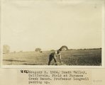
34
Gregory 2, 1924. Death Valley, California. Field at Furnace Creek Ranch. Professor Longwell packing up
1924
Image
35
Gregory 3, 1924. Panamint Range, California. View in Wood(?) Valley, next valley south of Harrisburg. Old surface covered with slate fragments
1924
Image
36
Herbert E. Gregory Book 10: San Juan, Zion, Capitol Reef, 1915-1938
1915; 1916; 1917; 1918; 1919; 1920; 1921; 1922; 1923; 1924; 1925; 1926; 1927; 1928; 1929; 1930; 1931; 1932; 1933; 1934; 1935; 1936; 1937; 1938
Image
37
Herbert E. Gregory Book 8: Arizona, Utah, Nevada, California, 1915-1922
1915; 1918; 1922; 1924
Image
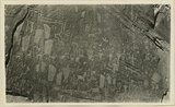
38
Herbert E. Gregory Book 9: Utah, California, 1924-1928
1875; 1907; 1921; 1924; 1925; 1927; 1928
Image
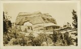
39
Indurated red fanglomerate lying against fault that crosses Cafe Spring wash at a point 5 miles below Cave Spring; 1696.
1924
Image
40
Inscriptions right bank, Glen Canyon below Smith's Fork
1920; 1921; 1922; 1923; 1924; 1925; 1926; 1927; 1928; 1929; 1930
Image
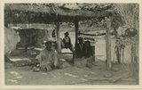
41
Jim Joe's House, U.S.G.S. = U.S. Geological Survey, Miser 654 (Robert T. Allen), near mouth of Butler Wash
1920; 1921; 1922; 1923; 1924; 1925; 1926; 1927; 1928; 1929; 1930
Image
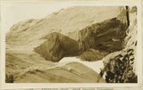
42
Keystone Arch, Arch Canyon, Coconino sandstone
1920; 1921; 1922; 1923; 1924; 1925; 1926; 1927; 1928; 1929; 1930
Image
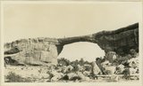
43
Keystone Arch, Arch Canyon, Coconino sandstone
1920; 1921; 1922; 1923; 1924; 1925; 1926; 1927; 1928; 1929; 1930
Image
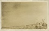
44
Limestone in 'Marine Jurassic' at a dry waterfall tributary to Virgin River, 2 miles SW of Mt. Carmel
1924
Image
45
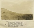
Longwell 1, Charleston Peak at about 11,000 feet
1924
Image
46
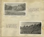
Longwell 10, Furnace Creek. Erosion in colored Tertiary beds
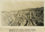
1924
Image
47
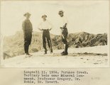
Longwell 11, Furnace Creek. Tertiary beds near Mineral Monument. Professor Gregory, Dr. Noble, Dr. Hewett
1924
Image
48
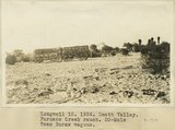
Longwell 12, Death Valley. Furnace Creek Ranch. 20-Mule Team Borax wagons
1924
Image
49
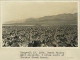
Longwell 13, Death Valley salt deposits, 9 miles south of Furnace Creek Ranch
1924
Image
50
Longwell 2, Charleston Peak viewed from the south
1924
Image
26
-
50
of
93
<
1
2
3
4
>