Over 70,000 photos covering a variety of topics from Marriott Library Special Collections
TO
| Title | Collection Number And Name | Photo Number | ||
|---|---|---|---|---|
| 51 |
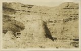 |
Detail view showing change in massiveness of beds of Waweap formation. along strike. Cannonville, Garfield County, UT, 1924 | P0013 Herbert E. Gregory Photograph Collection | P0013n09_009_1737 |
| 52 |
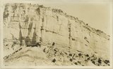 |
Yellow-red sandstone above gypsiferous shales, Waweap formation 3 miles SE of Cannonville. Equivalent of beds shown in photograph 1728. Garfield County, UT 1924 | P0013 Herbert E. Gregory Photograph Collection | P0013n09_009_1738 |
| 53 |
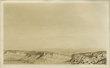 |
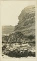
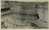
Cliffs of Waweap capped with Dakota. East side Dry Valley looking North. Top of Kaiparowits Plateau in distance. Kane County, UT. 1924 | P0013 Herbert E. Gregory Photograph Collection | P0013n09_010_1739 |
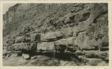
| 54 |
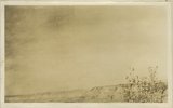 |
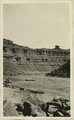
General view walls of Dry Valley, Kane County, UT 1924 | P0013 Herbert E. Gregory Photograph Collection | P0013n09_010_1740 |
| 55 |
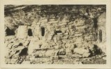 |
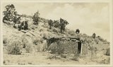
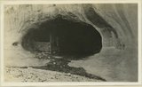
Cliff House, Fable Valley (Fred Lowrey, Honolulu) | P0013 Herbert E. Gregory Photograph Collection | P0013n09_145_1996 |
| 56 |
 |
Cliff House, Fable Valley (Fred Lowrey, Honolulu) | P0013 Herbert E. Gregory Photograph Collection | P0013n09_145_1997 |
| 57 |
 |
Cliff House, Fable Valley (Fred Lowrey, Honolulu) | P0013 Herbert E. Gregory Photograph Collection | P0013n09_145_1998 |
| 58 |
 |
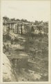
Survey headquarters, Blanding, UT. Lowrey | P0013 Herbert E. Gregory Photograph Collection | P0013n09_145_1999 |
| 59 |
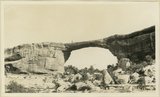 |
Edwin Bridge, White Canyon (Prof. L.M. Gould, University of Michigan, 1924.) | P0013 Herbert E. Gregory Photograph Collection | P0013n09_146_2000 |
| 60 |
 |
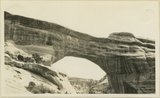
Caroline Bridge, White Canyon, 1924 | P0013 Herbert E. Gregory Photograph Collection | P0013n09_146_2001 |
| 61 |
 |
Augusta Bridge, White Canyon, 1924 | P0013 Herbert E. Gregory Photograph Collection | P0013n09_147_2002 |
| 62 |
 |
Waterfall after showers, White Canyon | P0013 Herbert E. Gregory Photograph Collection | P0013n09_147_2003 |
| 63 |
 |
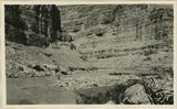
Wall of White Canyon, M. L. Gould, 1924, | P0013 Herbert E. Gregory Photograph Collection | P0013n09_148_2004 |
| 64 |
 |
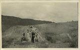
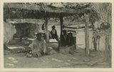
View of Allen Canyon country. Winter and summer Hogan, Piute Indians | P0013 Herbert E. Gregory Photograph Collection | P0013n09_149_2005 |
| 65 |
 |
Rock house, Piutes. Allen Canyon, L. M. Gould, 1924 | P0013 Herbert E. Gregory Photograph Collection | P0013n09_149_2006 |
| 66 |
 |
San Juan River between narrows and mouth of Chinle, U. S. G. S., Miser, 418 | P0013 Herbert E. Gregory Photograph Collection | P0013n09_151_2007 |
| 67 |
 |
San Juan Canyon between Honoker trail and Johns Canyon, Goodridge formation, Miser | P0013 Herbert E. Gregory Photograph Collection | P0013n09_152_2008 |
| 68 |
 |
San Juan Canyon at mouth of Grand Gulch. Goodridge, Moonlight, and Hermit formations, Miser | P0013 Herbert E. Gregory Photograph Collection | P0013n09_152_2009 |
| 69 |
 |
Red House in Red Canyon, U. S. G. S., Miser, 448 | P0013 Herbert E. Gregory Photograph Collection | P0013n09_153_2010 |
| 70 |
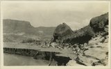 |
Sand Flat Skewer Camp, San Juan River | P0013 Herbert E. Gregory Photograph Collection | P0013n09_153_2011 |
| 71 |
 |
Abandoned Logan, San Juan River, 10 miles above mouth | P0013 Herbert E. Gregory Photograph Collection | P0013n09_154_2012 |
| 72 |
 |
Inscriptions right bank, Glen Canyon below Smith's Fork | P0013 Herbert E. Gregory Photograph Collection | P0013n09_154_2013 |
| 73 |
 |
Cliff house north side of San Juan near Bluff | P0013 Herbert E. Gregory Photograph Collection | P0013n09_155_2014 |
| 74 |
 |
Jim Joe's House, U.S.G.S. = U.S. Geological Survey, Miser 654 (Robert T. Allen), near mouth of Butler Wash | P0013 Herbert E. Gregory Photograph Collection | P0013n09_155_2015 |
| 75 |
 |
Tabernacle loop, San Juan River | P0013 Herbert E. Gregory Photograph Collection | P0013n09_156_2016 |