|
|
Title | Collection Number And Name | Photo Number |
| 1 |
 |
Camp scene, 6 miles north of Henrieville on Henrieville Creek. Marion Willis, packer. Garfield County, UT. 1922 | P0013 Herbert E. Gregory Photograph Collection | P0013n08_119_1539 |
| 2 |
 |
Camp scene, 6 miles north of Henrieville on Henrieville Creek. Dewey Moore Packer, Garfield County, UT. 1922 | P0013 Herbert E. Gregory Photograph Collection | P0013n08_119_1540 |
| 3 |
 |
Camp scene, 6 miles north of Henrieville on Henrieville Creek. Samuel Graff Packer, Garfield County, UT. 1922 | P0013 Herbert E. Gregory Photograph Collection | P0013n08_120_1541 |
| 4 |
 |
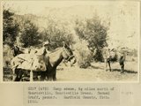
Camp scene, 30 miles east of Escalante. Kaiparowitz Plateau in background. Dr. Noble in foreground. Kane County, UT. 1922 | P0013 Herbert E. Gregory Photograph Collection | P0013n08_120_1542 |
| 5 |
 |
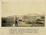
North face of Kaiparowitz Plateau at about 20-mile point. Kane County, UT. 1922 | P0013 Herbert E. Gregory Photograph Collection | P0013n08_121_1543 |
| 6 |
 |
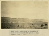
Floor of Escalante desert 30 miles east of Escalante, looking west. Kane County, UT. 1922 | P0013 Herbert E. Gregory Photograph Collection | P0013n08_121_1544 |
| 7 |
 |
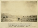
Northeast edge of Kaiparowitz Plateau from the top. Kane County, UT. 1922 | P0013 Herbert E. Gregory Photograph Collection | P0013n08_122_1545 |
| 8 |
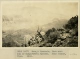 |
Navajo Mountain, from east end of Kaiparowitz Plateau. Kane County, UT. 1922 | P0013 Herbert E. Gregory Photograph Collection | P0013n08_122_1546 |
| 9 |
 |
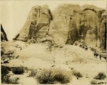
Trail to the top of Kaiparowitz Plateau at head of Rock Creek. Mancos and Mesa Verde strata. Kane County, UT. 1922 | P0013 Herbert E. Gregory Photograph Collection | P0013n08_123_1547 |
| 10 |
 |
Trail to the top of Kaiparowitz Plateau at head of Rock Creek. Mancos and Mesa Verde strata. Kane County, UT. 1922 | P0013 Herbert E. Gregory Photograph Collection | P0013n08_123_1548 |
| 11 |
 |
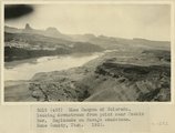
Glen Canyon of Colorado River near mouth of Rock Creek Canyon wall in Navajo, the top of which forms 'esplanades', slope in lower 'Sentinel,' cliffs in Sentinel sandstone, capped by Dakota. Kane County, UT. 1922 | P0013 Herbert E. Gregory Photograph Collection | P0013n08_124_1549 |
| 12 |
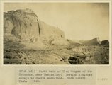 |
North bank of Glen Canyon of the Colorado, near Meskin Bar. Section includes Navajo to Dakota sandstone. Kane County, UT. 1922 | P0013 Herbert E. Gregory Photograph Collection | P0013n08_124_1550 |
| 13 |
 |
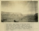
Glen Canyon of the Colorado, looking upstream from point 3 miles east of Crossing of the Fathers, near Meskin Bar. Kane County, UT. 1922 | P0013 Herbert E. Gregory Photograph Collection | P0013n08_125_1551 |
| 14 |
 |
Glen Canyon of Colorado, looking downstream from point near Meskin Bar, Esplanade on Navajo sandstone. Kane County, UT. 1922 | P0013 Herbert E. Gregory Photograph Collection | P0013n08_125_1552 |
| 15 |
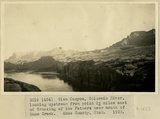 |
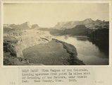
Glen Canyon, Colorado River, looking upstream from point 3 miles east of Crossing of the Fathers near mouth of Kane Creek. Kane County, UT. 1922 | P0013 Herbert E. Gregory Photograph Collection | P0013n08_126_1553 |
| 16 |
 |
Kane Springs Valley, east end of Gunsight Pass. Strata 'Sentinel' formation. Kane County, UT. 1922 | P0013 Herbert E. Gregory Photograph Collection | P0013n08_126_1554 |
| 17 |
 |
Kane Springs Valley, east end of Gunsight Pass. Strata 'Sentinel' formation. Kane County, UT. 1922 | P0013 Herbert E. Gregory Photograph Collection | P0013n08_127_1555 |
| 18 |
 |
Gunsight Pass between Last Chance Greek and Kane Creek. Kaiparowitz Plateau. Strata upper part " Sentinel" formation. Kane County, Utah. 1922 | P0013 Herbert E. Gregory Photograph Collection | P0013n08_127_1556 |
| 19 |
 |
Gunsight Pass between Last Chance Greek and Kane Creek. Kaiparowitz Plateau. Strata upper part " Sentinel" formation. Kane County, Utah. 1922 | P0013 Herbert E. Gregory Photograph Collection | P0013n08_127_1557 |
| 20 |
 |
Gunsight Pass from Last Chance Valley to Kane Springs Valley. Strata massive sandstone of 'Sentinel'. Kane County, UT. 1922 | P0013 Herbert E. Gregory Photograph Collection | P0013n08_128_1558 |
| 21 |
 |
Scene in Last Chance Creek. Kaiparowitz Plateau. Upper sandstone beds of 'Sentinel' formation in distance. Kane County, UT. 1922 | P0013 Herbert E. Gregory Photograph Collection | P0013n08_128_1559 |
| 22 |
 |
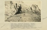
"Sentinel formation." Section B banded strata below heavy sandstone. Kaiparowitz region. Kane County, UT. 1922 | P0013 Herbert E. Gregory Photograph Collection | P0013n08_129_1560 |
| 23 |
 |
"Sentinel formation." Section B banded strata below heavy sandstone. Kaiparowitz region. Kane County, UT. 1922 | P0013 Herbert E. Gregory Photograph Collection | P0013n08_129_1561 |
| 24 |
 |
"Sentinel formation." Contact upper sandstone Section A with banded portion beneath, Section B. Cottonwood Canyon. Kane County, UT. 1922 | P0013 Herbert E. Gregory Photograph Collection | P0013n08_130_1562 |
| 25 |
 |
'"Sentinel formation." Contact upper sandstone just below Dakota, Section A, with banded strata beneath, Section B. Cottonwood Canyon. Kane County, UT. 1922 | P0013 Herbert E. Gregory Photograph Collection | P0013n08_130_1563 |