|
|
Title | Collection Number And Name | Photo Number |
| 1 |
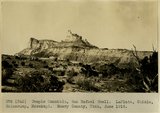 |
Temple Mountain, San Rafael Swell. LaPlata, Chinle, Shinarump, Moenkopi. Emery County, Utah, June 1918. | P0013 Herbert E. Gregory Photograph Collection | P0013n08_040_1387 |
| 2 |
 |
Hanksville, looking northeast down Fremont River. Wayne County, Utah. June 1918 | P0013 Herbert E. Gregory Photograph Collection | P0013n08_040_1388 |
| 3 |
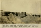 |
Hanksville, just below Dakota. Red-brown and chocolate gypsum shales. Wayne County, Utah. June 1918. | P0013 Herbert E. Gregory Photograph Collection | P0013n08_041_1389 |
| 4 |
 |
Hanksville. Gypsum seams in McElmo banded shale. Wayne County, Utah. June 1918. | P0013 Herbert E. Gregory Photograph Collection | P0013n08_041_1390 |
| 5 |
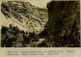 |
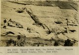
Capitol Reef Wash, San Rafael Swell. Wingate sandstone. Emery County, Utah. June 1918. | P0013 Herbert E. Gregory Photograph Collection | P0013n08_062_1421 |
| 6 |
 |
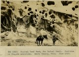
Capitol Reef Wash, San Rafael Swell. Wingate sandstone. Emery County, Utah. June 1918. | P0013 Herbert E. Gregory Photograph Collection | P0013n08_062_1422 |
| 7 |
 |
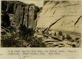
Capitol Reef Wash, San Rafael Swell. Wingate sandstone. Emery County, UT. June 1918 | P0013 Herbert E. Gregory Photograph Collection | P0013n08_063_1423 |
| 8 |
 |
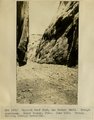
Capitol Reef Wash, San Rafael Swell. Cavities in Wingate sandstone. Emery County, UT. June 1918 | P0013 Herbert E. Gregory Photograph Collection | P0013n08_063_1424 |
| 9 |
 |
Capitol Reef Wash, San Rafael Swell. Navajo sandstone. Emery Co., UT. June 1918. Stream cutting through monocline | P0013 Herbert E. Gregory Photograph Collection | P0013n08_064_1425 |
| 10 |
 |
Between Notom and Bowns Ranch. Gypsum dike in McElmo sandstone. Wayne County, UT. June 1918 | P0013 Herbert E. Gregory Photograph Collection | P0013n08_064_1426 |
| 11 |
 |
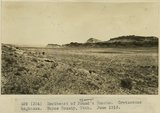
Southeast of Bowns Ranch. Cretaceous strata. Wayne County, UT. June 1918 | P0013 Herbert E. Gregory Photograph Collection | P0013n08_065_1427 |
| 12 |
 |
Southeast of Bowns Ranch. Cretaceous hogbacks. Wayne County, UT. June 1918 | P0013 Herbert E. Gregory Photograph Collection | P0013n08_065_1428 |
| 13 |
 |
East of Bowns Ranch. Cretaceous strata. Wayne County, UT. June 1918 | P0013 Herbert E. Gregory Photograph Collection | P0013n08_066_1429 |
| 14 |
 |
Looking east from Bitter Water Divide. Cretaceous strata. Wayne County, UT. June 1918 | P0013 Herbert E. Gregory Photograph Collection | P0013n08_066_1430 |
| 15 |
 |
View looking east from near divide at head of Water Pocket Canyon. Cretaceous strata, hogback. Garfield County, UT. June 1918 | P0013 Herbert E. Gregory Photograph Collection | P0013n08_067_1431 |
| 16 |
 |
Head of Water Pocket Valley. Sharp turn in axis of fold in Cretaceous sandstone. Garfield County, UT. June 1918 | P0013 Herbert E. Gregory Photograph Collection | P0013n08_067_1432 |
| 17 |
 |
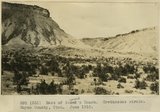
Water Pocket Fold, head of Burr Trail. Wingate sandstone. Garfield County, UT. June 1918 | P0013 Herbert E. Gregory Photograph Collection | P0013n08_068_1433 |
| 18 |
 |
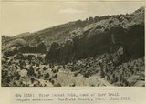
Water Pocket Fold near foot of Burr Trail. General view Cretaceous strata. Garfield County, UT. June 1918 | P0013 Herbert E. Gregory Photograph Collection | P0013n08_068_1434 |
| 19 |
 |
East of the foot of Burr Trail, Water Pocket Fold. Cretaceous strata. Garfield County, UT. June 1918 | P0013 Herbert E. Gregory Photograph Collection | P0013n08_069_1435 |
| 20 |
 |
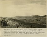
Water Pocket Fold, looking south from the foot of Burr Trail. Upturned Dakota, McElmo, and LaPlata. Garfield County, UT. June 1918 | P0013 Herbert E. Gregory Photograph Collection | P0013n08_069_1436 |
| 21 |
 |
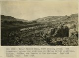
Water Pocket Fold, view looking north from a point 4 miles south of the foot of Burr Trail. Red limestone, gypsum and sandstone overlying Navajo sandstone. Cretaceous in the distance. Garfield County, UT. June 1918 | P0013 Herbert E. Gregory Photograph Collection | P0013n08_070_1437 |
| 22 |
 |
Water Pocket Fold, view looking south. Red limestone, gypsum and sandstone overlying Navajo sandstone. LaPlata, McElmo, and Dakota in the distance. Garfield County, UT. June 1918 | P0013 Herbert E. Gregory Photograph Collection | P0013n08_070_1438 |
| 23 |
 |
Water Pocket Fold on trail to Smith (Baker) Ranch on Hall Creek. Landslide of Chinle material over LaPlata. Kane County, UT. June 1918 | P0013 Herbert E. Gregory Photograph Collection | P0013n08_071_1439 |
| 24 |
 |
Water Pocket Fold. Looking north 30 degrees west along Hall Creek Valley near where stream leaves McElmo to enter LaPlata. Kane County, UT. June 1918 | P0013 Herbert E. Gregory Photograph Collection | P0013n08_071_1440 |
| 25 |
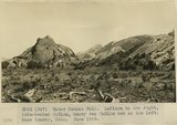 |
Water Pocket Fold. LaPlata to the right, thin-bedded McElmo, heavy red McElmo bed at the left. Kane County, UT. June 1918 | P0013 Herbert E. Gregory Photograph Collection | P0013n08_072_1441 |